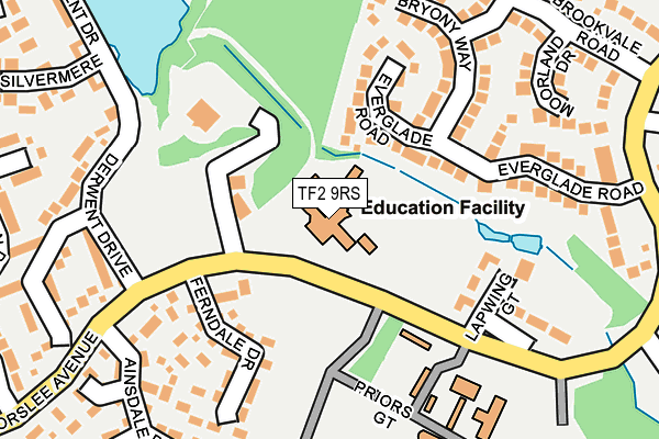
TF2 9RS is located in the Priorslee electoral ward, within the unitary authority of Telford and Wrekin and the English Parliamentary constituency of Telford. The Sub Integrated Care Board (ICB) Location is NHS Shropshire, Telford and Wrekin ICB - M2L0M and the police force is West Mercia. This postcode has been in use since February 1990.


GetTheData
Source: OS OpenMap – Local (Ordnance Survey)
Source: OS VectorMap District (Ordnance Survey)
Licence: Open Government Licence (requires attribution)
| Easting | 371303 |
| Northing | 309933 |
| Latitude | 52.686321 |
| Longitude | -2.425964 |
GetTheData
Source: Open Postcode Geo
Licence: Open Government Licence
| Country | England |
| Postcode District | TF2 |
➜ See where TF2 is on a map ➜ Where is Telford? | |
GetTheData
Source: Land Registry Price Paid Data
Licence: Open Government Licence
Elevation or altitude of TF2 9RS as distance above sea level:
| Metres | Feet | |
|---|---|---|
| Elevation | 150m | 492ft |
Elevation is measured from the approximate centre of the postcode, to the nearest point on an OS contour line from OS Terrain 50, which has contour spacing of ten vertical metres.
➜ How high above sea level am I? Find the elevation of your current position using your device's GPS.
GetTheData
Source: Open Postcode Elevation
Licence: Open Government Licence
| Ward | Priorslee |
| Constituency | Telford |
GetTheData
Source: ONS Postcode Database
Licence: Open Government Licence
| Lapwing Gate (Priorslee Avenue) | Priorslee | 116m |
| Lapwing Gate (Priorslee Avenue) | Priorslee | 196m |
| Ainsdale Drive (Priorslee Avenue) | Priorslee | 249m |
| Everglade Road (Priorslee Avenue) | Priorslee | 278m |
| Ainsdale Drive (Priorslee Avenue) | Priorslee | 282m |
| Telford Central Station | 1.2km |
| Oakengates Station | 1.8km |
| Shifnal Station | 4.3km |
GetTheData
Source: NaPTAN
Licence: Open Government Licence
Estimated total energy consumption in TF2 9RS by fuel type, 2015.
| Consumption (kWh) | 26,911 |
|---|---|
| Meter count | 7 |
| Mean (kWh/meter) | 3,844 |
| Median (kWh/meter) | 4,386 |
GetTheData
Source: Postcode level gas estimates: 2015 (experimental)
Source: Postcode level electricity estimates: 2015 (experimental)
Licence: Open Government Licence
GetTheData
Source: ONS Postcode Database
Licence: Open Government Licence


➜ Get more ratings from the Food Standards Agency
GetTheData
Source: Food Standards Agency
Licence: FSA terms & conditions
| Last Collection | |||
|---|---|---|---|
| Location | Mon-Fri | Sat | Distance |
| Stafford Park 4 | 18:15 | 11:30 | 1,109m |
| Stafford Park 4 Meter Box | 18:15 | 1,114m | |
| Halesfield 18 | 18:00 | 11:30 | 1,241m |
GetTheData
Source: Dracos
Licence: Creative Commons Attribution-ShareAlike
The below table lists the International Territorial Level (ITL) codes (formerly Nomenclature of Territorial Units for Statistics (NUTS) codes) and Local Administrative Units (LAU) codes for TF2 9RS:
| ITL 1 Code | Name |
|---|---|
| TLG | West Midlands (England) |
| ITL 2 Code | Name |
| TLG2 | Shropshire and Staffordshire |
| ITL 3 Code | Name |
| TLG21 | Telford and Wrekin |
| LAU 1 Code | Name |
| E06000020 | Telford and Wrekin |
GetTheData
Source: ONS Postcode Directory
Licence: Open Government Licence
The below table lists the Census Output Area (OA), Lower Layer Super Output Area (LSOA), and Middle Layer Super Output Area (MSOA) for TF2 9RS:
| Code | Name | |
|---|---|---|
| OA | E00071615 | |
| LSOA | E01014183 | Telford and Wrekin 015C |
| MSOA | E02002942 | Telford and Wrekin 015 |
GetTheData
Source: ONS Postcode Directory
Licence: Open Government Licence
| TF2 9QS | Everglade Road | 125m |
| TF2 9QL | Ferndale Drive | 153m |
| TF2 9SU | Lapwing Gate | 185m |
| TF2 9NY | Priors Gate | 189m |
| TF2 9QU | Bryony Way | 193m |
| TF2 9QT | Everglade Road | 209m |
| TF2 9QX | Meadowsweet Drive | 233m |
| TF2 9RN | Moorland Drive | 239m |
| TF2 9QN | Derwent Drive | 249m |
| TF2 9QJ | Ainsdale Drive | 261m |
GetTheData
Source: Open Postcode Geo; Land Registry Price Paid Data
Licence: Open Government Licence