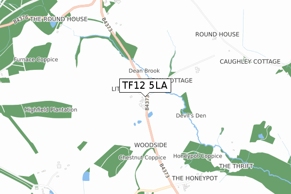
TF12 5LA is located in the Much Wenlock electoral ward, within the unitary authority of Shropshire and the English Parliamentary constituency of Ludlow. The Sub Integrated Care Board (ICB) Location is NHS Shropshire, Telford and Wrekin ICB - M2L0M and the police force is West Mercia. This postcode has been in use since January 1980.


GetTheData
Source: OS Open Zoomstack (Ordnance Survey)
Licence: Open Government Licence (requires attribution)
Attribution: Contains OS data © Crown copyright and database right 2024
Source: Open Postcode Geo
Licence: Open Government Licence (requires attribution)
Attribution: Contains OS data © Crown copyright and database right 2024; Contains Royal Mail data © Royal Mail copyright and database right 2024; Source: Office for National Statistics licensed under the Open Government Licence v.3.0
| Easting | 368144 |
| Northing | 299985 |
| Latitude | 52.596732 |
| Longitude | -2.471729 |
GetTheData
Source: Open Postcode Geo
Licence: Open Government Licence
| Country | England |
| Postcode District | TF12 |
➜ See where TF12 is on a map | |
GetTheData
Source: Land Registry Price Paid Data
Licence: Open Government Licence
Elevation or altitude of TF12 5LA as distance above sea level:
| Metres | Feet | |
|---|---|---|
| Elevation | 120m | 394ft |
Elevation is measured from the approximate centre of the postcode, to the nearest point on an OS contour line from OS Terrain 50, which has contour spacing of ten vertical metres.
➜ How high above sea level am I? Find the elevation of your current position using your device's GPS.
GetTheData
Source: Open Postcode Elevation
Licence: Open Government Licence
| Ward | Much Wenlock |
| Constituency | Ludlow |
GetTheData
Source: ONS Postcode Database
Licence: Open Government Licence
| Rudgewood Farm (B4373) | Willey | 776m |
| Rudgewood Farm (B4373) | Willey | 817m |
| Caughley Crescent Jct (Brookes Road) | Broseley | 1,213m |
| Riddings Close Jct (Guest Road) | Broseley | 1,305m |
| Wilkinson Avenue Jct (Bridgnorth Road) | Broseley | 1,434m |
GetTheData
Source: NaPTAN
Licence: Open Government Licence
| Percentage of properties with Next Generation Access | 100.0% |
| Percentage of properties with Superfast Broadband | 66.7% |
| Percentage of properties with Ultrafast Broadband | 0.0% |
| Percentage of properties with Full Fibre Broadband | 0.0% |
Superfast Broadband is between 30Mbps and 300Mbps
Ultrafast Broadband is > 300Mbps
| Percentage of properties unable to receive 2Mbps | 0.0% |
| Percentage of properties unable to receive 5Mbps | 0.0% |
| Percentage of properties unable to receive 10Mbps | 0.0% |
| Percentage of properties unable to receive 30Mbps | 33.3% |
GetTheData
Source: Ofcom
Licence: Ofcom Terms of Use (requires attribution)
GetTheData
Source: ONS Postcode Database
Licence: Open Government Licence


➜ Get more ratings from the Food Standards Agency
GetTheData
Source: Food Standards Agency
Licence: FSA terms & conditions
| Last Collection | |||
|---|---|---|---|
| Location | Mon-Fri | Sat | Distance |
| Linley Green | 16:30 | 07:15 | 816m |
| Forester Road | 12:30 | 12:00 | 1,314m |
| Broseley Rectory | 12:15 | 11:45 | 1,409m |
GetTheData
Source: Dracos
Licence: Creative Commons Attribution-ShareAlike
The below table lists the International Territorial Level (ITL) codes (formerly Nomenclature of Territorial Units for Statistics (NUTS) codes) and Local Administrative Units (LAU) codes for TF12 5LA:
| ITL 1 Code | Name |
|---|---|
| TLG | West Midlands (England) |
| ITL 2 Code | Name |
| TLG2 | Shropshire and Staffordshire |
| ITL 3 Code | Name |
| TLG22 | Shropshire |
| LAU 1 Code | Name |
| E06000051 | Shropshire |
GetTheData
Source: ONS Postcode Directory
Licence: Open Government Licence
The below table lists the Census Output Area (OA), Lower Layer Super Output Area (LSOA), and Middle Layer Super Output Area (MSOA) for TF12 5LA:
| Code | Name | |
|---|---|---|
| OA | E00146882 | |
| LSOA | E01028841 | Shropshire 029D |
| MSOA | E02006010 | Shropshire 029 |
GetTheData
Source: ONS Postcode Directory
Licence: Open Government Licence
| TF12 5JY | 809m | |
| TF12 5SS | Blakeway Close | 1079m |
| TF12 5SX | Whitmore Close | 1114m |
| TF12 5SG | Hurst Close | 1202m |
| TF12 5RZ | Guest Road | 1203m |
| TF12 5SB | Brookes Road | 1208m |
| TF12 5JE | Bridgnorth Road | 1247m |
| TF12 5SF | Tarbach Close | 1269m |
| TF12 5SP | Caughley Close | 1278m |
| TF12 5BS | Forester Road | 1280m |
GetTheData
Source: Open Postcode Geo; Land Registry Price Paid Data
Licence: Open Government Licence