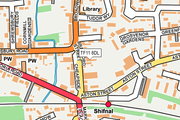
TF11 8DL is located in the Shifnal South and Cosford electoral ward, within the unitary authority of Shropshire and the English Parliamentary constituency of The Wrekin. The Sub Integrated Care Board (ICB) Location is NHS Shropshire, Telford and Wrekin ICB - M2L0M and the police force is West Mercia. This postcode has been in use since April 1987.


GetTheData
Source: OS OpenMap – Local (Ordnance Survey)
Source: OS VectorMap District (Ordnance Survey)
Licence: Open Government Licence (requires attribution)
| Easting | 374919 |
| Northing | 307797 |
| Latitude | 52.667315 |
| Longitude | -2.372306 |
GetTheData
Source: Open Postcode Geo
Licence: Open Government Licence
| Country | England |
| Postcode District | TF11 |
➜ See where TF11 is on a map ➜ Where is Shifnal? | |
GetTheData
Source: Land Registry Price Paid Data
Licence: Open Government Licence
Elevation or altitude of TF11 8DL as distance above sea level:
| Metres | Feet | |
|---|---|---|
| Elevation | 90m | 295ft |
Elevation is measured from the approximate centre of the postcode, to the nearest point on an OS contour line from OS Terrain 50, which has contour spacing of ten vertical metres.
➜ How high above sea level am I? Find the elevation of your current position using your device's GPS.
GetTheData
Source: Open Postcode Elevation
Licence: Open Government Licence
| Ward | Shifnal South And Cosford |
| Constituency | The Wrekin |
GetTheData
Source: ONS Postcode Database
Licence: Open Government Licence
| The Wheatsheaf (Broadway) | Shifnal | 96m |
| Jaspers Bar (Victoria Road) | Shifnal | 145m |
| Jaspers Bar (Victoria Road) | Shifnal | 171m |
| The Wheatsheaf (Broadway) | Shifnal | 189m |
| St Mary's Church (Victoria Road) | Shifnal | 295m |
| Shifnal Station | 0.1km |
| Telford Central Station | 4.9km |
| Cosford Station | 5.5km |
GetTheData
Source: NaPTAN
Licence: Open Government Licence
GetTheData
Source: ONS Postcode Database
Licence: Open Government Licence


➜ Get more ratings from the Food Standards Agency
GetTheData
Source: Food Standards Agency
Licence: FSA terms & conditions
| Last Collection | |||
|---|---|---|---|
| Location | Mon-Fri | Sat | Distance |
| Cheapside | 17:30 | 11:30 | 61m |
| Halesfield 18 Meter Box | 18:00 | 3,463m | |
| Stafford Park 4 Meter Box | 18:15 | 3,599m | |
GetTheData
Source: Dracos
Licence: Creative Commons Attribution-ShareAlike
The below table lists the International Territorial Level (ITL) codes (formerly Nomenclature of Territorial Units for Statistics (NUTS) codes) and Local Administrative Units (LAU) codes for TF11 8DL:
| ITL 1 Code | Name |
|---|---|
| TLG | West Midlands (England) |
| ITL 2 Code | Name |
| TLG2 | Shropshire and Staffordshire |
| ITL 3 Code | Name |
| TLG22 | Shropshire |
| LAU 1 Code | Name |
| E06000051 | Shropshire |
GetTheData
Source: ONS Postcode Directory
Licence: Open Government Licence
The below table lists the Census Output Area (OA), Lower Layer Super Output Area (LSOA), and Middle Layer Super Output Area (MSOA) for TF11 8DL:
| Code | Name | |
|---|---|---|
| OA | E00146963 | |
| LSOA | E01028856 | Shropshire 025D |
| MSOA | E02006008 | Shropshire 025 |
GetTheData
Source: ONS Postcode Directory
Licence: Open Government Licence
| TF11 8AU | Bradford Street | 22m |
| TF11 8BN | Cheapside | 74m |
| TF11 8AT | Bradford Street | 76m |
| TF11 8SR | Dunstanville Court | 93m |
| TF11 8FE | Victoria Road | 130m |
| TF11 8DW | Aston Street | 130m |
| TF11 8EB | Grosvenor Gardens | 141m |
| TF11 8AF | Victoria Road | 158m |
| TF11 8AQ | Shrewsbury Road | 184m |
| TF11 8AZ | Broadway | 186m |
GetTheData
Source: Open Postcode Geo; Land Registry Price Paid Data
Licence: Open Government Licence