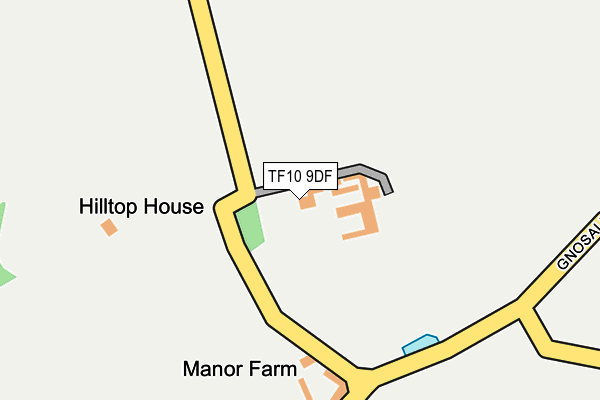
TF10 9DF is in Wilbrighton, Newport. TF10 9DF is located in the Gnosall & Woodseaves electoral ward, within the local authority district of Stafford and the English Parliamentary constituency of Stone. The Sub Integrated Care Board (ICB) Location is NHS Staffordshire and Stoke-on-Trent ICB - 05V and the police force is Staffordshire. This postcode has been in use since January 1980.


GetTheData
Source: OS OpenMap – Local (Ordnance Survey)
Source: OS VectorMap District (Ordnance Survey)
Licence: Open Government Licence (requires attribution)
| Easting | 379430 |
| Northing | 318617 |
| Latitude | 52.764757 |
| Longitude | -2.306287 |
GetTheData
Source: Open Postcode Geo
Licence: Open Government Licence
| Locality | Wilbrighton |
| Town/City | Newport |
| Country | England |
| Postcode District | TF10 |
➜ See where TF10 is on a map | |
GetTheData
Source: Land Registry Price Paid Data
Licence: Open Government Licence
Elevation or altitude of TF10 9DF as distance above sea level:
| Metres | Feet | |
|---|---|---|
| Elevation | 110m | 361ft |
Elevation is measured from the approximate centre of the postcode, to the nearest point on an OS contour line from OS Terrain 50, which has contour spacing of ten vertical metres.
➜ How high above sea level am I? Find the elevation of your current position using your device's GPS.
GetTheData
Source: Open Postcode Elevation
Licence: Open Government Licence
| Ward | Gnosall & Woodseaves |
| Constituency | Stone |
GetTheData
Source: ONS Postcode Database
Licence: Open Government Licence
| David's Pits Covert (Newport Road) | Beffcote | 1,178m |
| David's Pits Covert (Newport Road) | Beffcote | 1,187m |
| Cross Lane (Heath Road) | Bromstead Heath | 1,402m |
| Outwoods Road (Newport Road) | Outwoods | 1,480m |
| Outwoods Road (Newport Road) | Outwoods | 1,487m |
GetTheData
Source: NaPTAN
Licence: Open Government Licence
| Percentage of properties with Next Generation Access | 100.0% |
| Percentage of properties with Superfast Broadband | 0.0% |
| Percentage of properties with Ultrafast Broadband | 0.0% |
| Percentage of properties with Full Fibre Broadband | 0.0% |
Superfast Broadband is between 30Mbps and 300Mbps
Ultrafast Broadband is > 300Mbps
| Percentage of properties unable to receive 2Mbps | 0.0% |
| Percentage of properties unable to receive 5Mbps | 80.0% |
| Percentage of properties unable to receive 10Mbps | 80.0% |
| Percentage of properties unable to receive 30Mbps | 100.0% |
GetTheData
Source: Ofcom
Licence: Ofcom Terms of Use (requires attribution)
GetTheData
Source: ONS Postcode Database
Licence: Open Government Licence


➜ Get more ratings from the Food Standards Agency
GetTheData
Source: Food Standards Agency
Licence: FSA terms & conditions
| Last Collection | |||
|---|---|---|---|
| Location | Mon-Fri | Sat | Distance |
| Pave Lane | 10:00 | 09:30 | 3,777m |
| High Street | 17:15 | 09:00 | 4,050m |
| Gnosall Post Office | 16:45 | 11:15 | 4,183m |
GetTheData
Source: Dracos
Licence: Creative Commons Attribution-ShareAlike
The below table lists the International Territorial Level (ITL) codes (formerly Nomenclature of Territorial Units for Statistics (NUTS) codes) and Local Administrative Units (LAU) codes for TF10 9DF:
| ITL 1 Code | Name |
|---|---|
| TLG | West Midlands (England) |
| ITL 2 Code | Name |
| TLG2 | Shropshire and Staffordshire |
| ITL 3 Code | Name |
| TLG24 | Staffordshire CC |
| LAU 1 Code | Name |
| E07000197 | Stafford |
GetTheData
Source: ONS Postcode Directory
Licence: Open Government Licence
The below table lists the Census Output Area (OA), Lower Layer Super Output Area (LSOA), and Middle Layer Super Output Area (MSOA) for TF10 9DF:
| Code | Name | |
|---|---|---|
| OA | E00151374 | |
| LSOA | E01029706 | Stafford 015B |
| MSOA | E02006202 | Stafford 015 |
GetTheData
Source: ONS Postcode Directory
Licence: Open Government Licence
| TF10 9DG | 829m | |
| TF10 9ED | 851m | |
| TF10 9DQ | Lower Bromstead Lane | 919m |
| ST20 0ED | Broadhill | 921m |
| TF10 9EA | 1062m | |
| TF10 9DZ | 1133m | |
| TF10 9DT | Dykes Lane | 1164m |
| TF10 9DY | Moreton Bank Cottages | 1277m |
| TF10 9HX | Walnut Tree Lane | 1316m |
| TF10 9DS | 1339m |
GetTheData
Source: Open Postcode Geo; Land Registry Price Paid Data
Licence: Open Government Licence