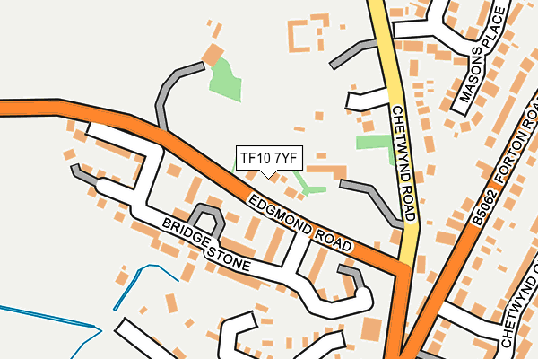
TF10 7YF is located in the Edgmond electoral ward, within the unitary authority of Telford and Wrekin and the English Parliamentary constituency of The Wrekin. The Sub Integrated Care Board (ICB) Location is NHS Shropshire, Telford and Wrekin ICB - M2L0M and the police force is West Mercia. This postcode has been in use since May 2017.


GetTheData
Source: OS OpenMap – Local (Ordnance Survey)
Source: OS VectorMap District (Ordnance Survey)
Licence: Open Government Licence (requires attribution)
| Easting | 374254 |
| Northing | 319791 |
| Latitude | 52.775102 |
| Longitude | -2.383085 |
GetTheData
Source: Open Postcode Geo
Licence: Open Government Licence
| Country | England |
| Postcode District | TF10 |
➜ See where TF10 is on a map ➜ Where is Newport? | |
GetTheData
Source: Land Registry Price Paid Data
Licence: Open Government Licence
| Ward | Edgmond |
| Constituency | The Wrekin |
GetTheData
Source: ONS Postcode Database
Licence: Open Government Licence
3, BEECH HILL GARDENS, NEWPORT, TF10 7YF 2017 25 AUG £545,000 |
2, BEECH HILL GARDENS, NEWPORT, TF10 7YF 2017 18 AUG £565,000 |
1, BEECH HILL GARDENS, NEWPORT, TF10 7YF 2017 4 MAY £550,000 |
GetTheData
Source: HM Land Registry Price Paid Data
Licence: Contains HM Land Registry data © Crown copyright and database right 2024. This data is licensed under the Open Government Licence v3.0.
| Edgmond Road (Chetwynd Road) | Newport | 172m |
| Avondale (Forton Road) | Newport | 275m |
| Green Lane (Chetwynd Road) | Newport | 295m |
| Green Lane (Chetwynd Road) | Newport | 307m |
| Masons Place | Newport | 319m |
GetTheData
Source: NaPTAN
Licence: Open Government Licence
| Percentage of properties with Next Generation Access | 100.0% |
| Percentage of properties with Superfast Broadband | 100.0% |
| Percentage of properties with Ultrafast Broadband | 0.0% |
| Percentage of properties with Full Fibre Broadband | 0.0% |
Superfast Broadband is between 30Mbps and 300Mbps
Ultrafast Broadband is > 300Mbps
| Percentage of properties unable to receive 2Mbps | 0.0% |
| Percentage of properties unable to receive 5Mbps | 0.0% |
| Percentage of properties unable to receive 10Mbps | 0.0% |
| Percentage of properties unable to receive 30Mbps | 0.0% |
GetTheData
Source: Ofcom
Licence: Ofcom Terms of Use (requires attribution)
GetTheData
Source: ONS Postcode Database
Licence: Open Government Licence


➜ Get more ratings from the Food Standards Agency
GetTheData
Source: Food Standards Agency
Licence: FSA terms & conditions
| Last Collection | |||
|---|---|---|---|
| Location | Mon-Fri | Sat | Distance |
| Chetwynd End | 17:00 | 11:30 | 222m |
| Masons Place | 17:00 | 11:30 | 414m |
| Mere Close | 17:15 | 11:30 | 453m |
GetTheData
Source: Dracos
Licence: Creative Commons Attribution-ShareAlike
The below table lists the International Territorial Level (ITL) codes (formerly Nomenclature of Territorial Units for Statistics (NUTS) codes) and Local Administrative Units (LAU) codes for TF10 7YF:
| ITL 1 Code | Name |
|---|---|
| TLG | West Midlands (England) |
| ITL 2 Code | Name |
| TLG2 | Shropshire and Staffordshire |
| ITL 3 Code | Name |
| TLG21 | Telford and Wrekin |
| LAU 1 Code | Name |
| E06000020 | Telford and Wrekin |
GetTheData
Source: ONS Postcode Directory
Licence: Open Government Licence
The below table lists the Census Output Area (OA), Lower Layer Super Output Area (LSOA), and Middle Layer Super Output Area (MSOA) for TF10 7YF:
| Code | Name | |
|---|---|---|
| OA | E00071362 | |
| LSOA | E01014131 | Telford and Wrekin 002B |
| MSOA | E02002929 | Telford and Wrekin 002 |
GetTheData
Source: ONS Postcode Directory
Licence: Open Government Licence
| TF10 7YD | Stone Bridge | 66m |
| TF10 7YB | Stone Bridge | 115m |
| TF10 7UE | Blue House Barns | 156m |
| TF10 7JZ | Chetwynd Road | 177m |
| TF10 7JP | Forton Road | 250m |
| TF10 7JT | Masons Place | 271m |
| TF10 7JJ | Chetwynd End | 272m |
| TF10 7LA | Green Lane | 273m |
| TF10 7JU | Masons Place | 286m |
| TF10 7JS | Masons Place | 290m |
GetTheData
Source: Open Postcode Geo; Land Registry Price Paid Data
Licence: Open Government Licence