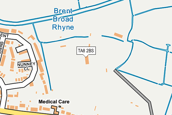
TA8 2BS is located in the Burnham on Sea North electoral ward, within the unitary authority of Somerset and the English Parliamentary constituency of Wells. The Sub Integrated Care Board (ICB) Location is NHS Somerset ICB - 11X and the police force is Avon and Somerset. This postcode has been in use since November 2013.


GetTheData
Source: OS OpenMap – Local (Ordnance Survey)
Source: OS VectorMap District (Ordnance Survey)
Licence: Open Government Licence (requires attribution)
| Easting | 331369 |
| Northing | 150353 |
| Latitude | 51.248197 |
| Longitude | -2.984702 |
GetTheData
Source: Open Postcode Geo
Licence: Open Government Licence
| Country | England |
| Postcode District | TA8 |
➜ See where TA8 is on a map | |
GetTheData
Source: Land Registry Price Paid Data
Licence: Open Government Licence
Elevation or altitude of TA8 2BS as distance above sea level:
| Metres | Feet | |
|---|---|---|
| Elevation | 10m | 33ft |
Elevation is measured from the approximate centre of the postcode, to the nearest point on an OS contour line from OS Terrain 50, which has contour spacing of ten vertical metres.
➜ How high above sea level am I? Find the elevation of your current position using your device's GPS.
GetTheData
Source: Open Postcode Elevation
Licence: Open Government Licence
| Ward | Burnham On Sea North |
| Constituency | Wells |
GetTheData
Source: ONS Postcode Database
Licence: Open Government Licence
| Rugby Club Entrance (Stodden's Road) | Burnham-on-sea | 337m |
| Rugby Club Entrance (Stodden's Road) | Burnham-on-sea | 347m |
| Creswick Way (Southern Lea Road) | Burnham-on-sea | 395m |
| Creswick Way (Southern Lea Road) | Burnham-on-sea | 401m |
| Caernarvon Way (Stodden's Road) | Burnham-on-sea | 468m |
| Highbridge & Burnham-on-Sea Station | 3.5km |
GetTheData
Source: NaPTAN
Licence: Open Government Licence
GetTheData
Source: ONS Postcode Database
Licence: Open Government Licence


➜ Get more ratings from the Food Standards Agency
GetTheData
Source: Food Standards Agency
Licence: FSA terms & conditions
| Last Collection | |||
|---|---|---|---|
| Location | Mon-Fri | Sat | Distance |
| Love Lane | 17:00 | 12:00 | 907m |
| Colony | 16:45 | 12:00 | 967m |
| Gore Road | 16:45 | 12:00 | 993m |
GetTheData
Source: Dracos
Licence: Creative Commons Attribution-ShareAlike
| Risk of TA8 2BS flooding from rivers and sea | Low |
| ➜ TA8 2BS flood map | |
GetTheData
Source: Open Flood Risk by Postcode
Licence: Open Government Licence
The below table lists the International Territorial Level (ITL) codes (formerly Nomenclature of Territorial Units for Statistics (NUTS) codes) and Local Administrative Units (LAU) codes for TA8 2BS:
| ITL 1 Code | Name |
|---|---|
| TLK | South West (England) |
| ITL 2 Code | Name |
| TLK2 | Dorset and Somerset |
| ITL 3 Code | Name |
| TLK23 | Somerset CC |
| LAU 1 Code | Name |
| E07000188 | Sedgemoor |
GetTheData
Source: ONS Postcode Directory
Licence: Open Government Licence
The below table lists the Census Output Area (OA), Lower Layer Super Output Area (LSOA), and Middle Layer Super Output Area (MSOA) for TA8 2BS:
| Code | Name | |
|---|---|---|
| OA | E00148293 | |
| LSOA | E01029115 | Sedgemoor 002E |
| MSOA | E02006062 | Sedgemoor 002 |
GetTheData
Source: ONS Postcode Directory
Licence: Open Government Licence
| TA8 2UW | Conway Crescent | 288m |
| TA8 2DE | Stoddens Road | 301m |
| TA8 2UL | Cadbury Close | 347m |
| TA8 2UN | Nunney Close | 348m |
| TA8 2EL | Stoddens Road | 380m |
| TA8 2DD | Stoddens Road | 387m |
| TA8 2ST | Warwick Gardens | 397m |
| TA8 2EE | Stoneleigh Close | 417m |
| TA8 2EH | Creswick Way | 424m |
| TA8 2EW | Eastleigh Close | 436m |
GetTheData
Source: Open Postcode Geo; Land Registry Price Paid Data
Licence: Open Government Licence