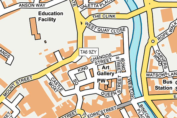
TA6 9ZY is located in the Bridgwater South electoral ward, within the unitary authority of Somerset and the English Parliamentary constituency of Bridgwater and West Somerset. The Sub Integrated Care Board (ICB) Location is NHS Somerset ICB - 11X and the police force is Avon and Somerset. This postcode has been in use since January 2005.


GetTheData
Source: OS OpenMap – Local (Ordnance Survey)
Source: OS VectorMap District (Ordnance Survey)
Licence: Open Government Licence (requires attribution)
| Easting | 329869 |
| Northing | 137240 |
| Latitude | 51.130125 |
| Longitude | -3.003616 |
GetTheData
Source: Open Postcode Geo
Licence: Open Government Licence
| Country | England |
| Postcode District | TA6 |
➜ See where TA6 is on a map ➜ Where is Bridgwater? | |
GetTheData
Source: Land Registry Price Paid Data
Licence: Open Government Licence
Elevation or altitude of TA6 9ZY as distance above sea level:
| Metres | Feet | |
|---|---|---|
| Elevation | 10m | 33ft |
Elevation is measured from the approximate centre of the postcode, to the nearest point on an OS contour line from OS Terrain 50, which has contour spacing of ten vertical metres.
➜ How high above sea level am I? Find the elevation of your current position using your device's GPS.
GetTheData
Source: Open Postcode Elevation
Licence: Open Government Licence
| Ward | Bridgwater South |
| Constituency | Bridgwater And West Somerset |
GetTheData
Source: ONS Postcode Database
Licence: Open Government Licence
| Magistrates Court (Mount Street) | Bridgwater | 108m |
| Castle Moat | Bridgwater | 155m |
| Watsons Lane (East Quay) | Bridgwater | 184m |
| Watsons Lane (East Quay) | Bridgwater | 197m |
| Angel Place (Northgate) | Bridgwater | 217m |
| Bridgwater Station | 1km |
GetTheData
Source: NaPTAN
Licence: Open Government Licence
GetTheData
Source: ONS Postcode Database
Licence: Open Government Licence


➜ Get more ratings from the Food Standards Agency
GetTheData
Source: Food Standards Agency
Licence: FSA terms & conditions
| Last Collection | |||
|---|---|---|---|
| Location | Mon-Fri | Sat | Distance |
| Blacklands | 17:30 | 12:00 | 203m |
| High Street | 17:30 | 12:15 | 230m |
| Angel Place | 17:30 | 12:15 | 233m |
GetTheData
Source: Dracos
Licence: Creative Commons Attribution-ShareAlike
The below table lists the International Territorial Level (ITL) codes (formerly Nomenclature of Territorial Units for Statistics (NUTS) codes) and Local Administrative Units (LAU) codes for TA6 9ZY:
| ITL 1 Code | Name |
|---|---|
| TLK | South West (England) |
| ITL 2 Code | Name |
| TLK2 | Dorset and Somerset |
| ITL 3 Code | Name |
| TLK23 | Somerset CC |
| LAU 1 Code | Name |
| E07000188 | Sedgemoor |
GetTheData
Source: ONS Postcode Directory
Licence: Open Government Licence
The below table lists the Census Output Area (OA), Lower Layer Super Output Area (LSOA), and Middle Layer Super Output Area (MSOA) for TA6 9ZY:
| Code | Name | |
|---|---|---|
| OA | E00148264 | |
| LSOA | E01029112 | Sedgemoor 009E |
| MSOA | E02006069 | Sedgemoor 009 |
GetTheData
Source: ONS Postcode Directory
Licence: Open Government Licence
| TA6 3DG | King Square | 61m |
| TA6 3DJ | King Square | 67m |
| TA6 3DL | Chandos Street | 70m |
| TA6 3EU | Chalice Mews | 84m |
| TA6 3DB | Castle Street | 94m |
| TA6 3HW | West Quay | 108m |
| TA6 3DD | Castle Street | 119m |
| TA6 3DA | Queen Street | 124m |
| TA6 3FE | Kings Place | 125m |
| TA6 3BS | York Buildings | 138m |
GetTheData
Source: Open Postcode Geo; Land Registry Price Paid Data
Licence: Open Government Licence