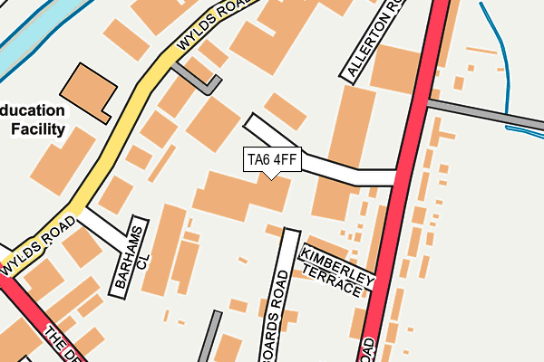
TA6 4FF lies on Bristol Road in Bridgwater. TA6 4FF is located in the Bridgwater North & Central electoral ward, within the unitary authority of Somerset and the English Parliamentary constituency of Bridgwater and West Somerset. The Sub Integrated Care Board (ICB) Location is NHS Somerset ICB - 11X and the police force is Avon and Somerset. This postcode has been in use since July 2009.


GetTheData
Source: OS OpenMap – Local (Ordnance Survey)
Source: OS VectorMap District (Ordnance Survey)
Licence: Open Government Licence (requires attribution)
| Easting | 330492 |
| Northing | 138168 |
| Latitude | 51.138540 |
| Longitude | -2.994901 |
GetTheData
Source: Open Postcode Geo
Licence: Open Government Licence
| Street | Bristol Road |
| Town/City | Bridgwater |
| Country | England |
| Postcode District | TA6 |
➜ See where TA6 is on a map ➜ Where is Bridgwater? | |
GetTheData
Source: Land Registry Price Paid Data
Licence: Open Government Licence
Elevation or altitude of TA6 4FF as distance above sea level:
| Metres | Feet | |
|---|---|---|
| Elevation | 10m | 33ft |
Elevation is measured from the approximate centre of the postcode, to the nearest point on an OS contour line from OS Terrain 50, which has contour spacing of ten vertical metres.
➜ How high above sea level am I? Find the elevation of your current position using your device's GPS.
GetTheData
Source: Open Postcode Elevation
Licence: Open Government Licence
| Ward | Bridgwater North & Central |
| Constituency | Bridgwater And West Somerset |
GetTheData
Source: ONS Postcode Database
Licence: Open Government Licence
| Premdor (Bristol Road) | Bridgwater | 129m |
| Premdor (Bristol Road) | Bridgwater | 140m |
| Wylds Road | Bridgwater | 221m |
| Wylds Road | Bridgwater | 229m |
| Filling Station (Bristol Road) | Bridgwater | 258m |
| Bridgwater Station | 1.2km |
GetTheData
Source: NaPTAN
Licence: Open Government Licence
GetTheData
Source: ONS Postcode Database
Licence: Open Government Licence


➜ Get more ratings from the Food Standards Agency
GetTheData
Source: Food Standards Agency
Licence: FSA terms & conditions
| Last Collection | |||
|---|---|---|---|
| Location | Mon-Fri | Sat | Distance |
| Western Way | 17:30 | 12:00 | 786m |
| Church Street | 17:30 | 12:00 | 865m |
| Anson Way | 17:30 | 12:00 | 987m |
GetTheData
Source: Dracos
Licence: Creative Commons Attribution-ShareAlike
| Risk of TA6 4FF flooding from rivers and sea | Low |
| ➜ TA6 4FF flood map | |
GetTheData
Source: Open Flood Risk by Postcode
Licence: Open Government Licence
The below table lists the International Territorial Level (ITL) codes (formerly Nomenclature of Territorial Units for Statistics (NUTS) codes) and Local Administrative Units (LAU) codes for TA6 4FF:
| ITL 1 Code | Name |
|---|---|
| TLK | South West (England) |
| ITL 2 Code | Name |
| TLK2 | Dorset and Somerset |
| ITL 3 Code | Name |
| TLK23 | Somerset CC |
| LAU 1 Code | Name |
| E07000188 | Sedgemoor |
GetTheData
Source: ONS Postcode Directory
Licence: Open Government Licence
The below table lists the Census Output Area (OA), Lower Layer Super Output Area (LSOA), and Middle Layer Super Output Area (MSOA) for TA6 4FF:
| Code | Name | |
|---|---|---|
| OA | E00148192 | |
| LSOA | E01029096 | Sedgemoor 008B |
| MSOA | E02006068 | Sedgemoor 008 |
GetTheData
Source: ONS Postcode Directory
Licence: Open Government Licence
| TA6 4BE | Kimberley Terrace | 150m |
| TA6 4BG | Bristol Road | 157m |
| TA6 4BS | Bristol Road | 172m |
| TA6 4BT | Bristol Road | 201m |
| TA6 4BB | Boards Road | 224m |
| TA6 4DH | Wylds Road | 297m |
| TA6 4BP | Bristol Road | 314m |
| TA6 4BA | Quantock Terrace | 457m |
| TA6 4BJ | Bristol Road | 509m |
| TA6 4AX | Bristol Road | 510m |
GetTheData
Source: Open Postcode Geo; Land Registry Price Paid Data
Licence: Open Government Licence