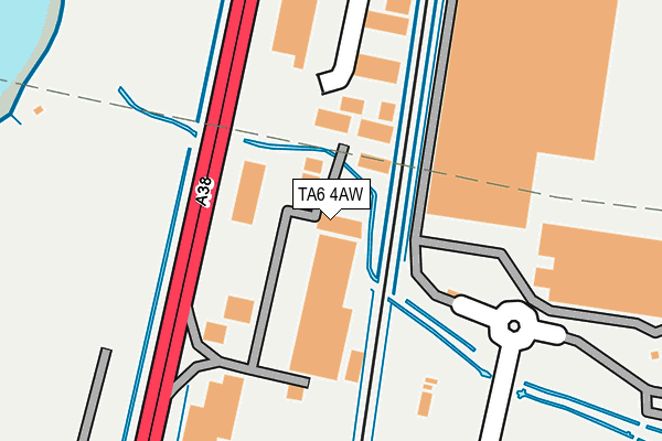
TA6 4AW is located in the Bridgwater East & Bawdrip electoral ward, within the unitary authority of Somerset and the English Parliamentary constituency of Bridgwater and West Somerset. The Sub Integrated Care Board (ICB) Location is NHS Somerset ICB - 11X and the police force is Avon and Somerset. This postcode has been in use since December 1996.


GetTheData
Source: OS OpenMap – Local (Ordnance Survey)
Source: OS VectorMap District (Ordnance Survey)
Licence: Open Government Licence (requires attribution)
| Easting | 331101 |
| Northing | 139717 |
| Latitude | 51.152539 |
| Longitude | -2.986495 |
GetTheData
Source: Open Postcode Geo
Licence: Open Government Licence
| Country | England |
| Postcode District | TA6 |
➜ See where TA6 is on a map ➜ Where is Bridgwater? | |
GetTheData
Source: Land Registry Price Paid Data
Licence: Open Government Licence
Elevation or altitude of TA6 4AW as distance above sea level:
| Metres | Feet | |
|---|---|---|
| Elevation | 10m | 33ft |
Elevation is measured from the approximate centre of the postcode, to the nearest point on an OS contour line from OS Terrain 50, which has contour spacing of ten vertical metres.
➜ How high above sea level am I? Find the elevation of your current position using your device's GPS.
GetTheData
Source: Open Postcode Elevation
Licence: Open Government Licence
| Ward | Bridgwater East & Bawdrip |
| Constituency | Bridgwater And West Somerset |
GetTheData
Source: ONS Postcode Database
Licence: Open Government Licence
| Express Park Industrial Estate | Bridgwater | 478m |
| Express Park Industrial Estate (Bristol Road) | Bridgwater | 504m |
| Kings Road Roundabout (Kings Drive) | Bridgwater | 558m |
| Kings Road Roundabout (Kings Drive) | Bridgwater | 564m |
| Stobarts | Bridgwater | 805m |
| Bridgwater Station | 2.8km |
GetTheData
Source: NaPTAN
Licence: Open Government Licence
GetTheData
Source: ONS Postcode Database
Licence: Open Government Licence


➜ Get more ratings from the Food Standards Agency
GetTheData
Source: Food Standards Agency
Licence: FSA terms & conditions
| Last Collection | |||
|---|---|---|---|
| Location | Mon-Fri | Sat | Distance |
| Coultings | 13:00 | 08:00 | 1,563m |
| Horsey | 12:00 | 11:15 | 1,590m |
| Western Way | 17:30 | 12:00 | 2,057m |
GetTheData
Source: Dracos
Licence: Creative Commons Attribution-ShareAlike
| Risk of TA6 4AW flooding from rivers and sea | Low |
| ➜ TA6 4AW flood map | |
GetTheData
Source: Open Flood Risk by Postcode
Licence: Open Government Licence
The below table lists the International Territorial Level (ITL) codes (formerly Nomenclature of Territorial Units for Statistics (NUTS) codes) and Local Administrative Units (LAU) codes for TA6 4AW:
| ITL 1 Code | Name |
|---|---|
| TLK | South West (England) |
| ITL 2 Code | Name |
| TLK2 | Dorset and Somerset |
| ITL 3 Code | Name |
| TLK23 | Somerset CC |
| LAU 1 Code | Name |
| E07000188 | Sedgemoor |
GetTheData
Source: ONS Postcode Directory
Licence: Open Government Licence
The below table lists the Census Output Area (OA), Lower Layer Super Output Area (LSOA), and Middle Layer Super Output Area (MSOA) for TA6 4AW:
| Code | Name | |
|---|---|---|
| OA | E00148181 | |
| LSOA | E01029090 | Sedgemoor 010A |
| MSOA | E02006070 | Sedgemoor 010 |
GetTheData
Source: ONS Postcode Directory
Licence: Open Government Licence
| TA6 4FJ | Bristol Road | 288m |
| TA6 4FR | Kings Walk | 399m |
| TA6 4GT | Lancaster Close | 434m |
| TA6 4FS | Royal Drive | 440m |
| TA6 4GF | Noble Street | 477m |
| TA6 4GH | Belgravia Drive | 507m |
| TA6 4GS | Bloomsbury Drive | 511m |
| TA6 4GG | Chatsworth Drive | 525m |
| TA6 4GJ | Belgravia Drive | 528m |
| TA6 4FT | Royal Drive | 545m |
GetTheData
Source: Open Postcode Geo; Land Registry Price Paid Data
Licence: Open Government Licence