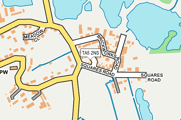
TA5 2NS is located in the Cannington electoral ward, within the unitary authority of Somerset and the English Parliamentary constituency of Bridgwater and West Somerset. The Sub Integrated Care Board (ICB) Location is NHS Somerset ICB - 11X and the police force is Avon and Somerset. This postcode has been in use since June 2017.


GetTheData
Source: OS OpenMap – Local (Ordnance Survey)
Source: OS VectorMap District (Ordnance Survey)
Licence: Open Government Licence (requires attribution)
| Easting | 329904 |
| Northing | 139196 |
| Latitude | 51.147710 |
| Longitude | -3.003505 |
GetTheData
Source: Open Postcode Geo
Licence: Open Government Licence
| Country | England |
| Postcode District | TA5 |
➜ See where TA5 is on a map ➜ Where is Chilton Trinity? | |
GetTheData
Source: Land Registry Price Paid Data
Licence: Open Government Licence
| Ward | Cannington |
| Constituency | Bridgwater And West Somerset |
GetTheData
Source: ONS Postcode Database
Licence: Open Government Licence
2024 26 APR £365,000 |
2022 6 DEC £450,000 |
7, BATH BRICK CLOSE, CHILTON TRINITY, BRIDGWATER, TA5 2NS 2017 6 OCT £324,995 |
2017 30 JUN £267,995 |
1, BATH BRICK CLOSE, CHILTON TRINITY, BRIDGWATER, TA5 2NS 2017 30 JUN £267,995 |
5, BATH BRICK CLOSE, CHILTON TRINITY, BRIDGWATER, TA5 2NS 2017 23 JUN £267,995 |
4, BATH BRICK CLOSE, CHILTON TRINITY, BRIDGWATER, TA5 2NS 2017 23 JUN £329,995 |
9, BATH BRICK CLOSE, CHILTON TRINITY, BRIDGWATER, TA5 2NS 2017 26 MAY £335,995 |
2017 19 MAY £347,995 |
➜ Chilton Trinity house prices
GetTheData
Source: HM Land Registry Price Paid Data
Licence: Contains HM Land Registry data © Crown copyright and database right 2025. This data is licensed under the Open Government Licence v3.0.
| Phone Box (Main Road) | Chilton Trinity | 107m |
| Chilton Trinity School (School Grounds) | Chilton Trinity | 891m |
| Stobarts (Bristol Road) | Bridgwater | 902m |
| Stobarts | Bridgwater | 935m |
| Express Park Industrial Estate (Bristol Road) | Bridgwater | 939m |
| Bridgwater Station | 2.4km |
GetTheData
Source: NaPTAN
Licence: Open Government Licence
| Percentage of properties with Next Generation Access | 100.0% |
| Percentage of properties with Superfast Broadband | 100.0% |
| Percentage of properties with Ultrafast Broadband | 100.0% |
| Percentage of properties with Full Fibre Broadband | 100.0% |
Superfast Broadband is between 30Mbps and 300Mbps
Ultrafast Broadband is > 300Mbps
| Percentage of properties unable to receive 2Mbps | 0.0% |
| Percentage of properties unable to receive 5Mbps | 0.0% |
| Percentage of properties unable to receive 10Mbps | 0.0% |
| Percentage of properties unable to receive 30Mbps | 0.0% |
GetTheData
Source: Ofcom
Licence: Ofcom Terms of Use (requires attribution)
GetTheData
Source: ONS Postcode Database
Licence: Open Government Licence


➜ Get more ratings from the Food Standards Agency
GetTheData
Source: Food Standards Agency
Licence: FSA terms & conditions
| Last Collection | |||
|---|---|---|---|
| Location | Mon-Fri | Sat | Distance |
| Coultings | 13:00 | 08:00 | 259m |
| Western Way | 17:30 | 12:00 | 1,010m |
| Wembdon Common | 17:30 | 12:00 | 1,629m |
GetTheData
Source: Dracos
Licence: Creative Commons Attribution-ShareAlike
| Risk of TA5 2NS flooding from rivers and sea | Low |
| ➜ TA5 2NS flood map | |
GetTheData
Source: Open Flood Risk by Postcode
Licence: Open Government Licence
The below table lists the International Territorial Level (ITL) codes (formerly Nomenclature of Territorial Units for Statistics (NUTS) codes) and Local Administrative Units (LAU) codes for TA5 2NS:
| ITL 1 Code | Name |
|---|---|
| TLK | South West (England) |
| ITL 2 Code | Name |
| TLK2 | Dorset and Somerset |
| ITL 3 Code | Name |
| TLK23 | Somerset CC |
| LAU 1 Code | Name |
| E07000188 | Sedgemoor |
GetTheData
Source: ONS Postcode Directory
Licence: Open Government Licence
The below table lists the Census Output Area (OA), Lower Layer Super Output Area (LSOA), and Middle Layer Super Output Area (MSOA) for TA5 2NS:
| Code | Name | |
|---|---|---|
| OA | E00148457 | |
| LSOA | E01032632 | Sedgemoor 011F |
| MSOA | E02006071 | Sedgemoor 011 |
GetTheData
Source: ONS Postcode Directory
Licence: Open Government Licence
| TA5 2JG | Brickworks Road | 34m |
| TA5 2BN | Council Houses | 67m |
| TA5 2JQ | Brickworks Road | 86m |
| TA5 2LW | Squares Road | 132m |
| TA5 2JE | Meadow Close | 209m |
| TA5 2BL | 223m | |
| TA5 2BH | 254m | |
| TA5 2BJ | Archstone Avenue | 285m |
| TA5 2BG | 533m | |
| TA5 2BS | 542m |
GetTheData
Source: Open Postcode Geo; Land Registry Price Paid Data
Licence: Open Government Licence