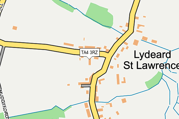
TA4 3RZ lies on Cridlands in Lydeard St Lawrence, Taunton. TA4 3RZ is located in the Lydeard electoral ward, within the unitary authority of Somerset and the English Parliamentary constituency of Taunton Deane. The Sub Integrated Care Board (ICB) Location is NHS Somerset ICB - 11X and the police force is Avon and Somerset. This postcode has been in use since January 1980.


GetTheData
Source: OS OpenMap – Local (Ordnance Survey)
Source: OS VectorMap District (Ordnance Survey)
Licence: Open Government Licence (requires attribution)
| Easting | 312785 |
| Northing | 132472 |
| Latitude | 51.084911 |
| Longitude | -3.246553 |
GetTheData
Source: Open Postcode Geo
Licence: Open Government Licence
| Street | Cridlands |
| Locality | Lydeard St Lawrence |
| Town/City | Taunton |
| Country | England |
| Postcode District | TA4 |
➜ See where TA4 is on a map ➜ Where is Lydeard St Lawrence? | |
GetTheData
Source: Land Registry Price Paid Data
Licence: Open Government Licence
Elevation or altitude of TA4 3RZ as distance above sea level:
| Metres | Feet | |
|---|---|---|
| Elevation | 110m | 361ft |
Elevation is measured from the approximate centre of the postcode, to the nearest point on an OS contour line from OS Terrain 50, which has contour spacing of ten vertical metres.
➜ How high above sea level am I? Find the elevation of your current position using your device's GPS.
GetTheData
Source: Open Postcode Elevation
Licence: Open Government Licence
| Ward | Lydeard |
| Constituency | Taunton Deane |
GetTheData
Source: ONS Postcode Database
Licence: Open Government Licence
| Post Office | Lydeard St Lawrence | 97m |
| Post Office | Lydeard St Lawrence | 98m |
| Pyleigh Manor Cottage | Handy Cross | 1,049m |
| Pyleigh Manor Cottage | Handy Cross | 1,079m |
| Bishop's Lydeard | 5km |
GetTheData
Source: NaPTAN
Licence: Open Government Licence
| Percentage of properties with Next Generation Access | 100.0% |
| Percentage of properties with Superfast Broadband | 100.0% |
| Percentage of properties with Ultrafast Broadband | 0.0% |
| Percentage of properties with Full Fibre Broadband | 0.0% |
Superfast Broadband is between 30Mbps and 300Mbps
Ultrafast Broadband is > 300Mbps
| Percentage of properties unable to receive 2Mbps | 0.0% |
| Percentage of properties unable to receive 5Mbps | 0.0% |
| Percentage of properties unable to receive 10Mbps | 0.0% |
| Percentage of properties unable to receive 30Mbps | 0.0% |
GetTheData
Source: Ofcom
Licence: Ofcom Terms of Use (requires attribution)
GetTheData
Source: ONS Postcode Database
Licence: Open Government Licence
| Last Collection | |||
|---|---|---|---|
| Location | Mon-Fri | Sat | Distance |
| Lydeard St Lawrence | 16:30 | 10:30 | 82m |
| Nethercott Way | 10:30 | 10:30 | 516m |
| Crowcombe Heathfield | 16:30 | 10:30 | 2,210m |
GetTheData
Source: Dracos
Licence: Creative Commons Attribution-ShareAlike
The below table lists the International Territorial Level (ITL) codes (formerly Nomenclature of Territorial Units for Statistics (NUTS) codes) and Local Administrative Units (LAU) codes for TA4 3RZ:
| ITL 1 Code | Name |
|---|---|
| TLK | South West (England) |
| ITL 2 Code | Name |
| TLK2 | Dorset and Somerset |
| ITL 3 Code | Name |
| TLK23 | Somerset CC |
| LAU 1 Code | Name |
| E07000246 | Somerset West and Taunton |
GetTheData
Source: ONS Postcode Directory
Licence: Open Government Licence
The below table lists the Census Output Area (OA), Lower Layer Super Output Area (LSOA), and Middle Layer Super Output Area (MSOA) for TA4 3RZ:
| Code | Name | |
|---|---|---|
| OA | E00149101 | |
| LSOA | E01029268 | Taunton Deane 001D |
| MSOA | E02006099 | Taunton Deane 001 |
GetTheData
Source: ONS Postcode Directory
Licence: Open Government Licence
| TA4 3RY | Crosscroft Cottages | 49m |
| TA4 3SD | Victoria Terrace | 61m |
| TA4 3SB | 81m | |
| TA4 3RX | 134m | |
| TA4 3SE | 193m | |
| TA4 3SF | 257m | |
| TA4 3SH | Westowe | 495m |
| TA4 3SG | Nethercott Way | 574m |
| TA4 3SQ | Nethercott Lane | 918m |
| TA4 3SN | 1031m |
GetTheData
Source: Open Postcode Geo; Land Registry Price Paid Data
Licence: Open Government Licence