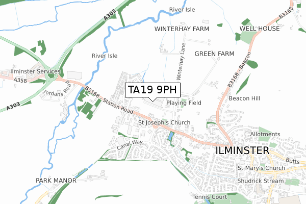
TA19 9PH is located in the Ilminster electoral ward, within the unitary authority of Somerset and the English Parliamentary constituency of Yeovil. The Sub Integrated Care Board (ICB) Location is NHS Somerset ICB - 11X and the police force is Avon and Somerset. This postcode has been in use since January 1980.


GetTheData
Source: OS Open Zoomstack (Ordnance Survey)
Licence: Open Government Licence (requires attribution)
Attribution: Contains OS data © Crown copyright and database right 2025
Source: Open Postcode Geo
Licence: Open Government Licence (requires attribution)
Attribution: Contains OS data © Crown copyright and database right 2025; Contains Royal Mail data © Royal Mail copyright and database right 2025; Source: Office for National Statistics licensed under the Open Government Licence v.3.0
| Easting | 335237 |
| Northing | 115071 |
| Latitude | 50.931428 |
| Longitude | -2.922951 |
GetTheData
Source: Open Postcode Geo
Licence: Open Government Licence
| Country | England |
| Postcode District | TA19 |
➜ See where TA19 is on a map ➜ Where is Ilminster? | |
GetTheData
Source: Land Registry Price Paid Data
Licence: Open Government Licence
Elevation or altitude of TA19 9PH as distance above sea level:
| Metres | Feet | |
|---|---|---|
| Elevation | 30m | 98ft |
Elevation is measured from the approximate centre of the postcode, to the nearest point on an OS contour line from OS Terrain 50, which has contour spacing of ten vertical metres.
➜ How high above sea level am I? Find the elevation of your current position using your device's GPS.
GetTheData
Source: Open Postcode Elevation
Licence: Open Government Licence
| Ward | Ilminster |
| Constituency | Yeovil |
GetTheData
Source: ONS Postcode Database
Licence: Open Government Licence
| St Joseph's Church (Station Road) | Ilminster | 150m |
| Winterhay Lane (Station Road) | Ilminster | 219m |
| Minster View | Ilminster | 245m |
| Minster View | Ilminster | 247m |
| Lord Nelson Inn (Station Road) | Winterhay Green | 300m |
GetTheData
Source: NaPTAN
Licence: Open Government Licence
GetTheData
Source: ONS Postcode Database
Licence: Open Government Licence


➜ Get more ratings from the Food Standards Agency
GetTheData
Source: Food Standards Agency
Licence: FSA terms & conditions
| Last Collection | |||
|---|---|---|---|
| Location | Mon-Fri | Sat | Distance |
| New Road | 16:45 | 12:00 | 428m |
| Canal Way | 16:15 | 11:45 | 432m |
| Ilminster Post Office | 17:15 | 12:15 | 1,145m |
GetTheData
Source: Dracos
Licence: Creative Commons Attribution-ShareAlike
The below table lists the International Territorial Level (ITL) codes (formerly Nomenclature of Territorial Units for Statistics (NUTS) codes) and Local Administrative Units (LAU) codes for TA19 9PH:
| ITL 1 Code | Name |
|---|---|
| TLK | South West (England) |
| ITL 2 Code | Name |
| TLK2 | Dorset and Somerset |
| ITL 3 Code | Name |
| TLK23 | Somerset CC |
| LAU 1 Code | Name |
| E07000189 | South Somerset |
GetTheData
Source: ONS Postcode Directory
Licence: Open Government Licence
The below table lists the Census Output Area (OA), Lower Layer Super Output Area (LSOA), and Middle Layer Super Output Area (MSOA) for TA19 9PH:
| Code | Name | |
|---|---|---|
| OA | E00166019 | |
| LSOA | E01029194 | South Somerset 019B |
| MSOA | E02006093 | South Somerset 019 |
GetTheData
Source: ONS Postcode Directory
Licence: Open Government Licence
| TA19 9BB | Winterhay Lane | 111m |
| TA19 9BQ | Station Road | 129m |
| TA19 9BA | Winterhay Lane | 169m |
| TA19 9BG | Station Road | 251m |
| TA19 9BF | Riec Sur Belon Way | 255m |
| TA19 9DG | Carnival Close | 261m |
| TA19 9DF | Green Lane | 281m |
| TA19 9BL | Station Road | 282m |
| TA19 9FG | Railway Cuttings | 291m |
| TA19 9RP | Hazelwell Lane | 321m |
GetTheData
Source: Open Postcode Geo; Land Registry Price Paid Data
Licence: Open Government Licence