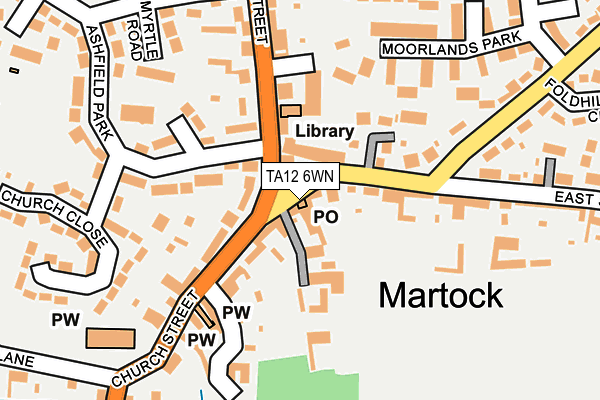
TA12 6WN is located in the Martock electoral ward, within the unitary authority of Somerset and the English Parliamentary constituency of Somerton and Frome. The Sub Integrated Care Board (ICB) Location is NHS Somerset ICB - 11X and the police force is Avon and Somerset. This postcode has been in use since April 2018.


GetTheData
Source: OS OpenMap – Local (Ordnance Survey)
Source: OS VectorMap District (Ordnance Survey)
Licence: Open Government Licence (requires attribution)
| Easting | 346312 |
| Northing | 119292 |
| Latitude | 50.970522 |
| Longitude | -2.765992 |
GetTheData
Source: Open Postcode Geo
Licence: Open Government Licence
| Country | England |
| Postcode District | TA12 |
➜ See where TA12 is on a map ➜ Where is Martock? | |
GetTheData
Source: Land Registry Price Paid Data
Licence: Open Government Licence
| Ward | Martock |
| Constituency | Somerton And Frome |
GetTheData
Source: ONS Postcode Database
Licence: Open Government Licence
| The Pinnacle (East Street) | Hurst | 33m |
| The Pinnacle (North Street) | Martock | 43m |
| The Pinnacle (North Street) | Martock | 105m |
| Paulls Close | Martock | 299m |
| Paulls Close | Martock | 309m |
GetTheData
Source: NaPTAN
Licence: Open Government Licence
GetTheData
Source: ONS Postcode Database
Licence: Open Government Licence


➜ Get more ratings from the Food Standards Agency
GetTheData
Source: Food Standards Agency
Licence: FSA terms & conditions
| Last Collection | |||
|---|---|---|---|
| Location | Mon-Fri | Sat | Distance |
| Martock Post Office | 17:00 | 12:30 | 6m |
| East Street | 16:30 | 08:00 | 457m |
| Water Street | 16:30 | 09:30 | 483m |
GetTheData
Source: Dracos
Licence: Creative Commons Attribution-ShareAlike
The below table lists the International Territorial Level (ITL) codes (formerly Nomenclature of Territorial Units for Statistics (NUTS) codes) and Local Administrative Units (LAU) codes for TA12 6WN:
| ITL 1 Code | Name |
|---|---|
| TLK | South West (England) |
| ITL 2 Code | Name |
| TLK2 | Dorset and Somerset |
| ITL 3 Code | Name |
| TLK23 | Somerset CC |
| LAU 1 Code | Name |
| E07000189 | South Somerset |
GetTheData
Source: ONS Postcode Directory
Licence: Open Government Licence
The below table lists the Census Output Area (OA), Lower Layer Super Output Area (LSOA), and Middle Layer Super Output Area (MSOA) for TA12 6WN:
| Code | Name | |
|---|---|---|
| OA | E00148769 | |
| LSOA | E01029205 | South Somerset 009D |
| MSOA | E02006083 | South Somerset 009 |
GetTheData
Source: ONS Postcode Directory
Licence: Open Government Licence
| TA12 6JQ | 0m | |
| TA12 6NE | The Green | 20m |
| TA12 6JJ | Manor Road | 94m |
| TA12 6DL | Martock Shopping Centre | 110m |
| TA12 6JL | Church Street | 119m |
| TA12 6NF | East Street | 125m |
| TA12 6DH | North Street | 150m |
| TA12 6DN | Moorlands Park | 179m |
| TA12 6EE | Ashfield Park | 184m |
| TA12 6ED | Myrtle Road | 195m |
GetTheData
Source: Open Postcode Geo; Land Registry Price Paid Data
Licence: Open Government Licence