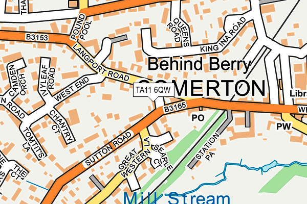
TA11 6QW lies on Bartletts Row in Somerton. TA11 6QW is located in the Somerton electoral ward, within the unitary authority of Somerset and the English Parliamentary constituency of Somerton and Frome. The Sub Integrated Care Board (ICB) Location is NHS Somerset ICB - 11X and the police force is Avon and Somerset. This postcode has been in use since January 1980.


GetTheData
Source: OS OpenMap – Local (Ordnance Survey)
Source: OS VectorMap District (Ordnance Survey)
Licence: Open Government Licence (requires attribution)
| Easting | 348634 |
| Northing | 128526 |
| Latitude | 51.053769 |
| Longitude | -2.734233 |
GetTheData
Source: Open Postcode Geo
Licence: Open Government Licence
| Street | Bartletts Row |
| Town/City | Somerton |
| Country | England |
| Postcode District | TA11 |
➜ See where TA11 is on a map ➜ Where is Somerton? | |
GetTheData
Source: Land Registry Price Paid Data
Licence: Open Government Licence
Elevation or altitude of TA11 6QW as distance above sea level:
| Metres | Feet | |
|---|---|---|
| Elevation | 30m | 98ft |
Elevation is measured from the approximate centre of the postcode, to the nearest point on an OS contour line from OS Terrain 50, which has contour spacing of ten vertical metres.
➜ How high above sea level am I? Find the elevation of your current position using your device's GPS.
GetTheData
Source: Open Postcode Elevation
Licence: Open Government Licence
| Ward | Somerton |
| Constituency | Somerton And Frome |
GetTheData
Source: ONS Postcode Database
Licence: Open Government Licence
| Opp Half Moon (Langport Road) | Somerton | 37m |
| Behind Berry | Somerton | 214m |
| White Hart (Market Place) | Somerton | 409m |
| Sunnyside (Langport Road) | Somerton | 480m |
| Sunnyside (Langport Road) | Somerton | 481m |
GetTheData
Source: NaPTAN
Licence: Open Government Licence
| Percentage of properties with Next Generation Access | 100.0% |
| Percentage of properties with Superfast Broadband | 100.0% |
| Percentage of properties with Ultrafast Broadband | 0.0% |
| Percentage of properties with Full Fibre Broadband | 0.0% |
Superfast Broadband is between 30Mbps and 300Mbps
Ultrafast Broadband is > 300Mbps
| Median download speed | 50.9Mbps |
| Average download speed | 49.3Mbps |
| Maximum download speed | 80.00Mbps |
| Median upload speed | 10.6Mbps |
| Average upload speed | 10.5Mbps |
| Maximum upload speed | 20.00Mbps |
| Percentage of properties unable to receive 2Mbps | 0.0% |
| Percentage of properties unable to receive 5Mbps | 0.0% |
| Percentage of properties unable to receive 10Mbps | 0.0% |
| Percentage of properties unable to receive 30Mbps | 0.0% |
GetTheData
Source: Ofcom
Licence: Ofcom Terms of Use (requires attribution)
Estimated total energy consumption in TA11 6QW by fuel type, 2015.
| Consumption (kWh) | 54,216 |
|---|---|
| Meter count | 7 |
| Mean (kWh/meter) | 7,745 |
| Median (kWh/meter) | 6,882 |
| Consumption (kWh) | 13,677 |
|---|---|
| Meter count | 6 |
| Mean (kWh/meter) | 2,280 |
| Median (kWh/meter) | 1,672 |
GetTheData
Source: Postcode level gas estimates: 2015 (experimental)
Source: Postcode level electricity estimates: 2015 (experimental)
Licence: Open Government Licence
GetTheData
Source: ONS Postcode Database
Licence: Open Government Licence


➜ Get more ratings from the Food Standards Agency
GetTheData
Source: Food Standards Agency
Licence: FSA terms & conditions
| Last Collection | |||
|---|---|---|---|
| Location | Mon-Fri | Sat | Distance |
| Somerton Post Office | 17:15 | 11:30 | 65m |
| Poundpool | 17:15 | 09:00 | 201m |
| Market Square | 17:15 | 08:45 | 416m |
GetTheData
Source: Dracos
Licence: Creative Commons Attribution-ShareAlike
The below table lists the International Territorial Level (ITL) codes (formerly Nomenclature of Territorial Units for Statistics (NUTS) codes) and Local Administrative Units (LAU) codes for TA11 6QW:
| ITL 1 Code | Name |
|---|---|
| TLK | South West (England) |
| ITL 2 Code | Name |
| TLK2 | Dorset and Somerset |
| ITL 3 Code | Name |
| TLK23 | Somerset CC |
| LAU 1 Code | Name |
| E07000189 | South Somerset |
GetTheData
Source: ONS Postcode Directory
Licence: Open Government Licence
The below table lists the Census Output Area (OA), Lower Layer Super Output Area (LSOA), and Middle Layer Super Output Area (MSOA) for TA11 6QW:
| Code | Name | |
|---|---|---|
| OA | E00148867 | |
| LSOA | E01029226 | South Somerset 003C |
| MSOA | E02006077 | South Somerset 003 |
GetTheData
Source: ONS Postcode Directory
Licence: Open Government Licence
| TA11 6NE | The Triangle | 38m |
| TA11 6NB | West Street | 52m |
| TA11 6QJ | The Triangle | 60m |
| TA11 6TG | Lawrence Close | 64m |
| TA11 6ND | The Triangle | 91m |
| TA11 6RR | Langport Road | 93m |
| TA11 6TD | Harding Court | 100m |
| TA11 6QH | West Street | 110m |
| TA11 6NA | West Street | 120m |
| TA11 6LA | King Ina Road | 123m |
GetTheData
Source: Open Postcode Geo; Land Registry Price Paid Data
Licence: Open Government Licence