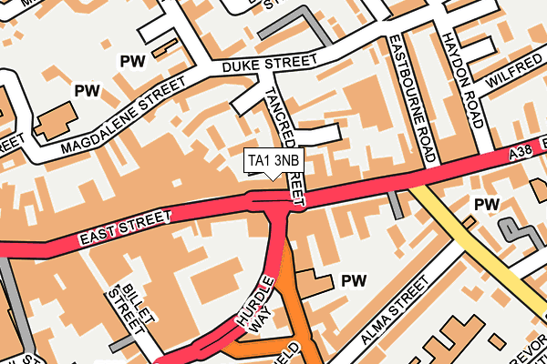
TA1 3NB lies on Eastgate in Taunton. TA1 3NB is located in the Taunton East electoral ward, within the unitary authority of Somerset and the English Parliamentary constituency of Taunton Deane. The Sub Integrated Care Board (ICB) Location is NHS Somerset ICB - 11X and the police force is Avon and Somerset. This postcode has been in use since January 1980.


GetTheData
Source: OS OpenMap – Local (Ordnance Survey)
Source: OS VectorMap District (Ordnance Survey)
Licence: Open Government Licence (requires attribution)
| Easting | 323118 |
| Northing | 124541 |
| Latitude | 51.015082 |
| Longitude | -3.097380 |
GetTheData
Source: Open Postcode Geo
Licence: Open Government Licence
| Street | Eastgate |
| Town/City | Taunton |
| Country | England |
| Postcode District | TA1 |
➜ See where TA1 is on a map ➜ Where is Taunton? | |
GetTheData
Source: Land Registry Price Paid Data
Licence: Open Government Licence
Elevation or altitude of TA1 3NB as distance above sea level:
| Metres | Feet | |
|---|---|---|
| Elevation | 20m | 66ft |
Elevation is measured from the approximate centre of the postcode, to the nearest point on an OS contour line from OS Terrain 50, which has contour spacing of ten vertical metres.
➜ How high above sea level am I? Find the elevation of your current position using your device's GPS.
GetTheData
Source: Open Postcode Elevation
Licence: Open Government Licence
| Ward | Taunton East |
| Constituency | Taunton Deane |
GetTheData
Source: ONS Postcode Database
Licence: Open Government Licence
| Alms Houses (East Street) | Taunton | 75m |
| Primark (East Street) | Taunton | 107m |
| South Street (Alma Street) | Taunton | 200m |
| Waterstones (East Street) | Taunton | 265m |
| Trinity School (South Street) | Taunton | 277m |
| Taunton Station | 1km |
GetTheData
Source: NaPTAN
Licence: Open Government Licence
| Median download speed | 14.9Mbps |
| Average download speed | 13.9Mbps |
| Maximum download speed | 20.29Mbps |
| Median upload speed | 1.1Mbps |
| Average upload speed | 1.0Mbps |
| Maximum upload speed | 1.17Mbps |
GetTheData
Source: Ofcom
Licence: Ofcom Terms of Use (requires attribution)
GetTheData
Source: ONS Postcode Database
Licence: Open Government Licence


➜ Get more ratings from the Food Standards Agency
GetTheData
Source: Food Standards Agency
Licence: FSA terms & conditions
| Last Collection | |||
|---|---|---|---|
| Location | Mon-Fri | Sat | Distance |
| East Reach | 17:00 | 11:45 | 42m |
| Halcon Corner | 17:00 | 11:30 | 344m |
| St Augustine Street | 17:00 | 12:30 | 412m |
GetTheData
Source: Dracos
Licence: Creative Commons Attribution-ShareAlike
The below table lists the International Territorial Level (ITL) codes (formerly Nomenclature of Territorial Units for Statistics (NUTS) codes) and Local Administrative Units (LAU) codes for TA1 3NB:
| ITL 1 Code | Name |
|---|---|
| TLK | South West (England) |
| ITL 2 Code | Name |
| TLK2 | Dorset and Somerset |
| ITL 3 Code | Name |
| TLK23 | Somerset CC |
| LAU 1 Code | Name |
| E07000246 | Somerset West and Taunton |
GetTheData
Source: ONS Postcode Directory
Licence: Open Government Licence
The below table lists the Census Output Area (OA), Lower Layer Super Output Area (LSOA), and Middle Layer Super Output Area (MSOA) for TA1 3NB:
| Code | Name | |
|---|---|---|
| OA | E00149193 | |
| LSOA | E01029284 | Taunton Deane 010B |
| MSOA | E02006108 | Taunton Deane 010 |
GetTheData
Source: ONS Postcode Directory
Licence: Open Government Licence
| TA1 3LS | East Street | 38m |
| TA1 1RA | Tancred Street | 47m |
| TA1 1RE | Eastgate Gardens | 66m |
| TA1 1RX | Gatehouse Court | 74m |
| TA1 1RD | Eastgate Gardens | 80m |
| TA1 3NA | East Street | 82m |
| TA1 3EN | East Reach | 100m |
| TA1 3HT | East Reach | 109m |
| TA1 3EW | East Reach | 132m |
| TA1 3DH | Silver Street | 141m |
GetTheData
Source: Open Postcode Geo; Land Registry Price Paid Data
Licence: Open Government Licence