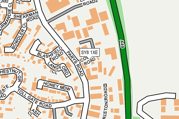
SY8 1XE lies on Coder Road in Ludlow Business Park, Ludlow. SY8 1XE is located in the Ludlow South electoral ward, within the unitary authority of Shropshire and the English Parliamentary constituency of Ludlow. The Sub Integrated Care Board (ICB) Location is NHS Shropshire, Telford and Wrekin ICB - M2L0M and the police force is West Mercia. This postcode has been in use since September 1991.


GetTheData
Source: OS OpenMap – Local (Ordnance Survey)
Source: OS VectorMap District (Ordnance Survey)
Licence: Open Government Licence (requires attribution)
| Easting | 352664 |
| Northing | 274608 |
| Latitude | 52.367465 |
| Longitude | -2.696636 |
GetTheData
Source: Open Postcode Geo
Licence: Open Government Licence
| Street | Coder Road |
| Locality | Ludlow Business Park |
| Town/City | Ludlow |
| Country | England |
| Postcode District | SY8 |
➜ See where SY8 is on a map ➜ Where is Ludlow? | |
GetTheData
Source: Land Registry Price Paid Data
Licence: Open Government Licence
Elevation or altitude of SY8 1XE as distance above sea level:
| Metres | Feet | |
|---|---|---|
| Elevation | 110m | 361ft |
Elevation is measured from the approximate centre of the postcode, to the nearest point on an OS contour line from OS Terrain 50, which has contour spacing of ten vertical metres.
➜ How high above sea level am I? Find the elevation of your current position using your device's GPS.
GetTheData
Source: Open Postcode Elevation
Licence: Open Government Licence
| Ward | Ludlow South |
| Constituency | Ludlow |
GetTheData
Source: ONS Postcode Database
Licence: Open Government Licence
| Blashfield Rd Jct (Parys Road) | Ludlow | 101m |
| Blashfield Rd Jct (Parys Road) | Ludlow | 122m |
| Depot (Parys Road) | Ludlow | 249m |
| Depot (Parys Road) | Ludlow | 255m |
| Chestnut Grove Jct (Tollgate) | Ludlow | 269m |
| Ludlow Station | 1.4km |
GetTheData
Source: NaPTAN
Licence: Open Government Licence
GetTheData
Source: ONS Postcode Database
Licence: Open Government Licence


➜ Get more ratings from the Food Standards Agency
GetTheData
Source: Food Standards Agency
Licence: FSA terms & conditions
| Last Collection | |||
|---|---|---|---|
| Location | Mon-Fri | Sat | Distance |
| Gravel Hill | 17:00 | 10:45 | 1,195m |
| Tower Street Post Office | 17:45 | 12:30 | 1,348m |
| East Hamlet | 17:30 | 11:00 | 1,357m |
GetTheData
Source: Dracos
Licence: Creative Commons Attribution-ShareAlike
The below table lists the International Territorial Level (ITL) codes (formerly Nomenclature of Territorial Units for Statistics (NUTS) codes) and Local Administrative Units (LAU) codes for SY8 1XE:
| ITL 1 Code | Name |
|---|---|
| TLG | West Midlands (England) |
| ITL 2 Code | Name |
| TLG2 | Shropshire and Staffordshire |
| ITL 3 Code | Name |
| TLG22 | Shropshire |
| LAU 1 Code | Name |
| E06000051 | Shropshire |
GetTheData
Source: ONS Postcode Directory
Licence: Open Government Licence
The below table lists the Census Output Area (OA), Lower Layer Super Output Area (LSOA), and Middle Layer Super Output Area (MSOA) for SY8 1XE:
| Code | Name | |
|---|---|---|
| OA | E00147750 | |
| LSOA | E01029011 | Shropshire 038F |
| MSOA | E02006045 | Shropshire 038 |
GetTheData
Source: ONS Postcode Directory
Licence: Open Government Licence
| SY8 1UF | Langford Close | 98m |
| SY8 1TG | Honey Meadow | 162m |
| SY8 1UE | Blashfield Road | 180m |
| SY8 1XB | Parys Road | 211m |
| SY8 1UG | Bowdler Close | 271m |
| SY8 1UQ | Shearman Road | 271m |
| SY8 1TJ | Chestnut Grove | 281m |
| SY8 1TQ | Toll Gate Road | 282m |
| SY8 1LR | Sheet Road | 285m |
| SY8 1UH | James Close | 308m |
GetTheData
Source: Open Postcode Geo; Land Registry Price Paid Data
Licence: Open Government Licence