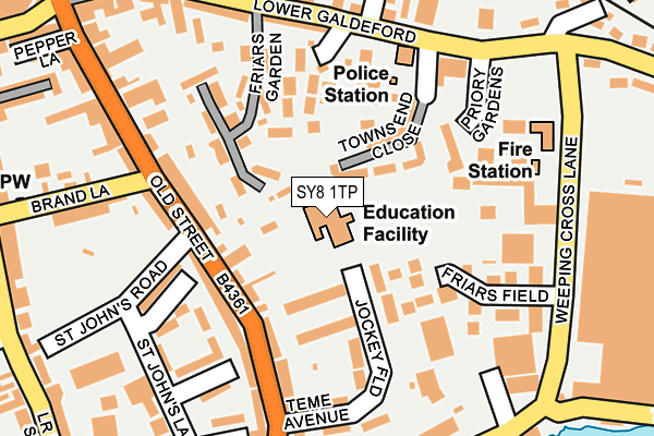
SY8 1TP is located in the Ludlow North electoral ward, within the unitary authority of Shropshire and the English Parliamentary constituency of Ludlow. The Sub Integrated Care Board (ICB) Location is NHS Shropshire, Telford and Wrekin ICB - M2L0M and the police force is West Mercia. This postcode has been in use since January 1992.


GetTheData
Source: OS OpenMap – Local (Ordnance Survey)
Source: OS VectorMap District (Ordnance Survey)
Licence: Open Government Licence (requires attribution)
| Easting | 351494 |
| Northing | 274496 |
| Latitude | 52.366356 |
| Longitude | -2.713802 |
GetTheData
Source: Open Postcode Geo
Licence: Open Government Licence
| Country | England |
| Postcode District | SY8 |
➜ See where SY8 is on a map ➜ Where is Ludlow? | |
GetTheData
Source: Land Registry Price Paid Data
Licence: Open Government Licence
Elevation or altitude of SY8 1TP as distance above sea level:
| Metres | Feet | |
|---|---|---|
| Elevation | 90m | 295ft |
Elevation is measured from the approximate centre of the postcode, to the nearest point on an OS contour line from OS Terrain 50, which has contour spacing of ten vertical metres.
➜ How high above sea level am I? Find the elevation of your current position using your device's GPS.
GetTheData
Source: Open Postcode Elevation
Licence: Open Government Licence
| Ward | Ludlow North |
| Constituency | Ludlow |
GetTheData
Source: ONS Postcode Database
Licence: Open Government Licence
| No. 109 (Old Street) | Ludlow | 104m |
| No. 78 (Old Street) | Ludlow | 122m |
| Police Station (Lower Galdeford) | Ludlow | 178m |
| Police Station (Lower Galdeford) | Ludlow | 186m |
| Friarfields (Weeping Cross Lane) | Ludlow | 220m |
| Ludlow Station | 0.6km |
GetTheData
Source: NaPTAN
Licence: Open Government Licence
GetTheData
Source: ONS Postcode Database
Licence: Open Government Licence


➜ Get more ratings from the Food Standards Agency
GetTheData
Source: Food Standards Agency
Licence: FSA terms & conditions
| Last Collection | |||
|---|---|---|---|
| Location | Mon-Fri | Sat | Distance |
| Tower Street Post Office | 17:45 | 12:30 | 283m |
| Bull Ring | 17:45 | 11:45 | 315m |
| Broad Street | 17:30 | 11:45 | 325m |
GetTheData
Source: Dracos
Licence: Creative Commons Attribution-ShareAlike
The below table lists the International Territorial Level (ITL) codes (formerly Nomenclature of Territorial Units for Statistics (NUTS) codes) and Local Administrative Units (LAU) codes for SY8 1TP:
| ITL 1 Code | Name |
|---|---|
| TLG | West Midlands (England) |
| ITL 2 Code | Name |
| TLG2 | Shropshire and Staffordshire |
| ITL 3 Code | Name |
| TLG22 | Shropshire |
| LAU 1 Code | Name |
| E06000051 | Shropshire |
GetTheData
Source: ONS Postcode Directory
Licence: Open Government Licence
The below table lists the Census Output Area (OA), Lower Layer Super Output Area (LSOA), and Middle Layer Super Output Area (MSOA) for SY8 1TP:
| Code | Name | |
|---|---|---|
| OA | E00147737 | |
| LSOA | E01033526 | Shropshire 038H |
| MSOA | E02006045 | Shropshire 038 |
GetTheData
Source: ONS Postcode Directory
Licence: Open Government Licence
| SY8 1TE | Lower Galdeford | 88m |
| SY8 1PU | Jockey Field | 96m |
| SY8 1NT | Friars Walk | 97m |
| SY8 1UN | Townsend Close | 98m |
| SY8 1NU | Old Street | 116m |
| SY8 1UR | Priory Gardens | 126m |
| SY8 1RX | Friars Garden | 127m |
| SY8 1UP | Priory Gardens | 133m |
| SY8 1NS | Old Street | 136m |
| SY8 1NX | Old Street | 137m |
GetTheData
Source: Open Postcode Geo; Land Registry Price Paid Data
Licence: Open Government Licence