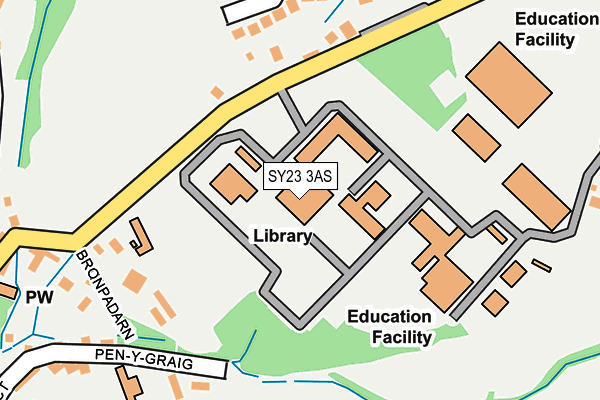
SY23 3AS is located in the Llanbadarn Fawr electoral ward, within the unitary authority of Ceredigion and the Welsh Parliamentary constituency of Ceredigion. The Local Health Board is Hywel Dda University and the police force is Dyfed-Powys. This postcode has been in use since January 1980.


GetTheData
Source: OS OpenMap – Local (Ordnance Survey)
Source: OS VectorMap District (Ordnance Survey)
Licence: Open Government Licence (requires attribution)
| Easting | 260363 |
| Northing | 281137 |
| Latitude | 52.410363 |
| Longitude | -4.054328 |
GetTheData
Source: Open Postcode Geo
Licence: Open Government Licence
| Country | Wales |
| Postcode District | SY23 |
➜ See where SY23 is on a map ➜ Where is Llanbadarn Fawr? | |
GetTheData
Source: Land Registry Price Paid Data
Licence: Open Government Licence
Elevation or altitude of SY23 3AS as distance above sea level:
| Metres | Feet | |
|---|---|---|
| Elevation | 60m | 197ft |
Elevation is measured from the approximate centre of the postcode, to the nearest point on an OS contour line from OS Terrain 50, which has contour spacing of ten vertical metres.
➜ How high above sea level am I? Find the elevation of your current position using your device's GPS.
GetTheData
Source: Open Postcode Elevation
Licence: Open Government Licence
| Ward | Llanbadarn Fawr |
| Constituency | Ceredigion |
GetTheData
Source: ONS Postcode Database
Licence: Open Government Licence
| Rural Studies Institute (Primrose Hill) | Llanbadarn Fawr | 123m |
| Rural Studies Institute (Primrose Hill) | Llanbadarn Fawr | 124m |
| Llanbadarn Square (Primrose Hill) | Llanbadarn Fawr | 418m |
| Pwllhobi (A44) | Llanbadarn Fawr | 421m |
| War Memorial (Heol-y-llan) | Llanbadarn Fawr | 430m |
| Llanbadarn (Vale Of Rheidol Railway) | Llanbadarn Fawr | 698m |
| Glanrafon (Vale Of Rheidol Railway) | Glanyrafon | 1,334m |
| Aberystwyth Station | 1.9km |
GetTheData
Source: NaPTAN
Licence: Open Government Licence
GetTheData
Source: ONS Postcode Database
Licence: Open Government Licence


➜ Get more ratings from the Food Standards Agency
GetTheData
Source: Food Standards Agency
Licence: FSA terms & conditions
| Last Collection | |||
|---|---|---|---|
| Location | Mon-Fri | Sat | Distance |
| Bronpadarn Campus | 16:45 | 11:45 | 42m |
| Heol - Y - Llan | 16:45 | 11:45 | 428m |
| Pendre | 16:45 | 11:30 | 619m |
GetTheData
Source: Dracos
Licence: Creative Commons Attribution-ShareAlike
The below table lists the International Territorial Level (ITL) codes (formerly Nomenclature of Territorial Units for Statistics (NUTS) codes) and Local Administrative Units (LAU) codes for SY23 3AS:
| ITL 1 Code | Name |
|---|---|
| TLL | Wales |
| ITL 2 Code | Name |
| TLL1 | West Wales and The Valleys |
| ITL 3 Code | Name |
| TLL14 | South West Wales |
| LAU 1 Code | Name |
| W06000008 | Ceredigion |
GetTheData
Source: ONS Postcode Directory
Licence: Open Government Licence
The below table lists the Census Output Area (OA), Lower Layer Super Output Area (LSOA), and Middle Layer Super Output Area (MSOA) for SY23 3AS:
| Code | Name | |
|---|---|---|
| OA | W00002828 | |
| LSOA | W01001936 | Ceredigion 003F |
| MSOA | W02000118 | Ceredigion 003 |
GetTheData
Source: ONS Postcode Directory
Licence: Open Government Licence
| SY23 3AT | Primrose Hill | 166m |
| SY23 3SE | Primrose Hill | 250m |
| SY23 3JG | Cefn Esgair | 272m |
| SY23 3SG | Penygraig | 293m |
| SY23 3TU | Cwmpadarn | 343m |
| SY23 3AU | Lluest | 354m |
| SY23 3SH | Heol Iwan | 360m |
| SY23 3SF | Primrose Hill | 378m |
| SY23 3SJ | 383m | |
| SY23 3SP | Brynrheidol Estate | 388m |
GetTheData
Source: Open Postcode Geo; Land Registry Price Paid Data
Licence: Open Government Licence