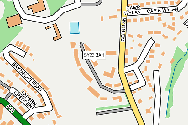
SY23 3AH is located in the Llanbadarn Fawr electoral ward, within the unitary authority of Ceredigion and the Welsh Parliamentary constituency of Ceredigion. The Local Health Board is Hywel Dda University and the police force is Dyfed-Powys. This postcode has been in use since April 1986.


GetTheData
Source: OS OpenMap – Local (Ordnance Survey)
Source: OS VectorMap District (Ordnance Survey)
Licence: Open Government Licence (requires attribution)
| Easting | 259852 |
| Northing | 281347 |
| Latitude | 52.412119 |
| Longitude | -4.061923 |
GetTheData
Source: Open Postcode Geo
Licence: Open Government Licence
| Country | Wales |
| Postcode District | SY23 |
➜ See where SY23 is on a map ➜ Where is Llanbadarn Fawr? | |
GetTheData
Source: Land Registry Price Paid Data
Licence: Open Government Licence
Elevation or altitude of SY23 3AH as distance above sea level:
| Metres | Feet | |
|---|---|---|
| Elevation | 70m | 230ft |
Elevation is measured from the approximate centre of the postcode, to the nearest point on an OS contour line from OS Terrain 50, which has contour spacing of ten vertical metres.
➜ How high above sea level am I? Find the elevation of your current position using your device's GPS.
GetTheData
Source: Open Postcode Elevation
Licence: Open Government Licence
| Ward | Llanbadarn Fawr |
| Constituency | Ceredigion |
GetTheData
Source: ONS Postcode Database
Licence: Open Government Licence
| Ambulance Station (Quebec Road) | Aberystwyth | 290m |
| Ambulance Station (Quebec Road) | Llanbadarn Fawr | 298m |
| St Padarn's Church (Heol Y Llan) | Llanbadarn Fawr | 339m |
| St Padarn`s Church (Heol-y-llan) | Llanbadarn Fawr | 346m |
| Penweddig School (Plascrug Avenue) | Aberystwyth | 408m |
| Llanbadarn (Vale Of Rheidol Railway) | Llanbadarn Fawr | 659m |
| Aberystwyth Station | 1.4km |
GetTheData
Source: NaPTAN
Licence: Open Government Licence
| Median download speed | 27.4Mbps |
| Average download speed | 30.3Mbps |
| Maximum download speed | 49.22Mbps |
| Median upload speed | 8.1Mbps |
| Average upload speed | 7.2Mbps |
| Maximum upload speed | 9.30Mbps |
GetTheData
Source: Ofcom
Licence: Ofcom Terms of Use (requires attribution)
Estimated total energy consumption in SY23 3AH by fuel type, 2015.
| Consumption (kWh) | 278,041 |
|---|---|
| Meter count | 18 |
| Mean (kWh/meter) | 15,447 |
| Median (kWh/meter) | 11,190 |
GetTheData
Source: Postcode level gas estimates: 2015 (experimental)
Source: Postcode level electricity estimates: 2015 (experimental)
Licence: Open Government Licence
GetTheData
Source: ONS Postcode Database
Licence: Open Government Licence


➜ Get more ratings from the Food Standards Agency
GetTheData
Source: Food Standards Agency
Licence: FSA terms & conditions
| Last Collection | |||
|---|---|---|---|
| Location | Mon-Fri | Sat | Distance |
| Heol - Y - Llan | 16:45 | 11:45 | 441m |
| Llangawsai | 17:00 | 11:45 | 507m |
| Bronpadarn Campus | 16:45 | 11:45 | 521m |
GetTheData
Source: Dracos
Licence: Creative Commons Attribution-ShareAlike
The below table lists the International Territorial Level (ITL) codes (formerly Nomenclature of Territorial Units for Statistics (NUTS) codes) and Local Administrative Units (LAU) codes for SY23 3AH:
| ITL 1 Code | Name |
|---|---|
| TLL | Wales |
| ITL 2 Code | Name |
| TLL1 | West Wales and The Valleys |
| ITL 3 Code | Name |
| TLL14 | South West Wales |
| LAU 1 Code | Name |
| W06000008 | Ceredigion |
GetTheData
Source: ONS Postcode Directory
Licence: Open Government Licence
The below table lists the Census Output Area (OA), Lower Layer Super Output Area (LSOA), and Middle Layer Super Output Area (MSOA) for SY23 3AH:
| Code | Name | |
|---|---|---|
| OA | W00002831 | |
| LSOA | W01001936 | Ceredigion 003F |
| MSOA | W02000118 | Ceredigion 003 |
GetTheData
Source: ONS Postcode Directory
Licence: Open Government Licence
| SY23 3AP | 110m | |
| SY23 3TF | Cefnllan | 166m |
| SY23 3QR | Brynglas Road | 185m |
| SY23 3TU | Cwmpadarn | 212m |
| SY23 3TT | 228m | |
| SY23 3QW | Padarn Crescent | 290m |
| SY23 3GY | Caer Wylan | 311m |
| SY23 3QT | Quebec Road | 316m |
| SY23 3QG | Cwmpadarn | 325m |
| SY23 1HG | Llanbadarn Road | 360m |
GetTheData
Source: Open Postcode Geo; Land Registry Price Paid Data
Licence: Open Government Licence