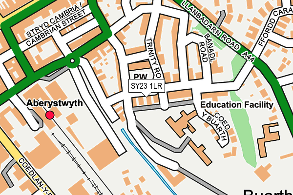
SY23 1LR lies on Buarth Road in Aberystwyth. SY23 1LR is located in the Aberystwyth Morfa a Glais electoral ward, within the unitary authority of Ceredigion and the Welsh Parliamentary constituency of Ceredigion. The Local Health Board is Hywel Dda University and the police force is Dyfed-Powys. This postcode has been in use since January 1980.


GetTheData
Source: OS OpenMap – Local (Ordnance Survey)
Source: OS VectorMap District (Ordnance Survey)
Licence: Open Government Licence (requires attribution)
| Easting | 258743 |
| Northing | 281593 |
| Latitude | 52.414043 |
| Longitude | -4.078320 |
GetTheData
Source: Open Postcode Geo
Licence: Open Government Licence
| Street | Buarth Road |
| Town/City | Aberystwyth |
| Country | Wales |
| Postcode District | SY23 |
➜ See where SY23 is on a map ➜ Where is Aberystwyth? | |
GetTheData
Source: Land Registry Price Paid Data
Licence: Open Government Licence
Elevation or altitude of SY23 1LR as distance above sea level:
| Metres | Feet | |
|---|---|---|
| Elevation | 10m | 33ft |
Elevation is measured from the approximate centre of the postcode, to the nearest point on an OS contour line from OS Terrain 50, which has contour spacing of ten vertical metres.
➜ How high above sea level am I? Find the elevation of your current position using your device's GPS.
GetTheData
Source: Open Postcode Elevation
Licence: Open Government Licence
| Ward | Aberystwyth Morfa A Glais |
| Constituency | Ceredigion |
GetTheData
Source: ONS Postcode Database
Licence: Open Government Licence
| Moor Lane (Thespian Street) | Aberystwyth | 189m |
| Social Security (Northgate Street) | Aberystwyth | 226m |
| Ystwyth Retail Park (Park Avenue) | Aberystwyth | 253m |
| St David`s Road (Llanbadarn Road) | Aberystwyth | 273m |
| Llanbadarn Road | Aberystwyth | 278m |
| Llanbadarn (Vale Of Rheidol Railway) | Llanbadarn Fawr | 1,413m |
| Aberystwyth Station | 0.2km |
GetTheData
Source: NaPTAN
Licence: Open Government Licence
| Percentage of properties with Next Generation Access | 100.0% |
| Percentage of properties with Superfast Broadband | 100.0% |
| Percentage of properties with Ultrafast Broadband | 0.0% |
| Percentage of properties with Full Fibre Broadband | 0.0% |
Superfast Broadband is between 30Mbps and 300Mbps
Ultrafast Broadband is > 300Mbps
| Median download speed | 67.0Mbps |
| Average download speed | 64.2Mbps |
| Maximum download speed | 80.00Mbps |
| Median upload speed | 17.7Mbps |
| Average upload speed | 15.8Mbps |
| Maximum upload speed | 20.00Mbps |
| Percentage of properties unable to receive 2Mbps | 0.0% |
| Percentage of properties unable to receive 5Mbps | 0.0% |
| Percentage of properties unable to receive 10Mbps | 0.0% |
| Percentage of properties unable to receive 30Mbps | 0.0% |
GetTheData
Source: Ofcom
Licence: Ofcom Terms of Use (requires attribution)
Estimated total energy consumption in SY23 1LR by fuel type, 2015.
| Consumption (kWh) | 139,270 |
|---|---|
| Meter count | 9 |
| Mean (kWh/meter) | 15,474 |
| Median (kWh/meter) | 11,600 |
| Consumption (kWh) | 46,699 |
|---|---|
| Meter count | 12 |
| Mean (kWh/meter) | 3,892 |
| Median (kWh/meter) | 2,074 |
GetTheData
Source: Postcode level gas estimates: 2015 (experimental)
Source: Postcode level electricity estimates: 2015 (experimental)
Licence: Open Government Licence
GetTheData
Source: ONS Postcode Database
Licence: Open Government Licence


➜ Get more ratings from the Food Standards Agency
GetTheData
Source: Food Standards Agency
Licence: FSA terms & conditions
| Last Collection | |||
|---|---|---|---|
| Location | Mon-Fri | Sat | Distance |
| Buarth Road | 17:00 | 11:45 | 43m |
| Alexandra Road | 17:30 | 11:45 | 245m |
| Alexandra Road | 17:30 | 11:45 | 245m |
GetTheData
Source: Dracos
Licence: Creative Commons Attribution-ShareAlike
The below table lists the International Territorial Level (ITL) codes (formerly Nomenclature of Territorial Units for Statistics (NUTS) codes) and Local Administrative Units (LAU) codes for SY23 1LR:
| ITL 1 Code | Name |
|---|---|
| TLL | Wales |
| ITL 2 Code | Name |
| TLL1 | West Wales and The Valleys |
| ITL 3 Code | Name |
| TLL14 | South West Wales |
| LAU 1 Code | Name |
| W06000008 | Ceredigion |
GetTheData
Source: ONS Postcode Directory
Licence: Open Government Licence
The below table lists the Census Output Area (OA), Lower Layer Super Output Area (LSOA), and Middle Layer Super Output Area (MSOA) for SY23 1LR:
| Code | Name | |
|---|---|---|
| OA | W00002738 | |
| LSOA | W01000512 | Ceredigion 002A |
| MSOA | W02000117 | Ceredigion 002 |
GetTheData
Source: ONS Postcode Directory
Licence: Open Government Licence
| SY23 1NB | Buarth Road | 76m |
| SY23 1LS | Stanley Road | 79m |
| SY23 1LP | Elm Tree Avenue | 87m |
| SY23 1LT | Trinity Place | 97m |
| SY23 1LZ | Edgehill Road | 126m |
| SY23 1LU | Trinity Road | 133m |
| SY23 1LW | Stanley Terrace | 137m |
| SY23 1NA | Banadl Road | 142m |
| SY23 1NE | Coed Y Buarth | 153m |
| SY23 2NP | Clos Penri | 165m |
GetTheData
Source: Open Postcode Geo; Land Registry Price Paid Data
Licence: Open Government Licence