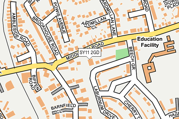
SY11 2GD is located in the Oswestry East electoral ward, within the unitary authority of Shropshire and the English Parliamentary constituency of North Shropshire. The Sub Integrated Care Board (ICB) Location is NHS Shropshire, Telford and Wrekin ICB - M2L0M and the police force is West Mercia. This postcode has been in use since May 2017.


GetTheData
Source: OS OpenMap – Local (Ordnance Survey)
Source: OS VectorMap District (Ordnance Survey)
Licence: Open Government Licence (requires attribution)
| Easting | 329657 |
| Northing | 329494 |
| Latitude | 52.858335 |
| Longitude | -3.046179 |
GetTheData
Source: Open Postcode Geo
Licence: Open Government Licence
| Country | England |
| Postcode District | SY11 |
➜ See where SY11 is on a map ➜ Where is Oswestry? | |
GetTheData
Source: Land Registry Price Paid Data
Licence: Open Government Licence
| Ward | Oswestry East |
| Constituency | North Shropshire |
GetTheData
Source: ONS Postcode Database
Licence: Open Government Licence
| Beechgrove School (Beech Grove) | Oswestry | 146m |
| Beechgrove School (Middleton Road) | Oswestry | 201m |
| Walford Road Jct (Monkmoor Road) | Oswestry | 288m |
| Hazel Grove Jct (Cherry Tree Drive) | Oswestry | 315m |
| Hazel Grove Jct (Cherry Tree Drive) | Oswestry | 321m |
| Gobowen Station | 4km |
GetTheData
Source: NaPTAN
Licence: Open Government Licence
| Percentage of properties with Next Generation Access | 100.0% |
| Percentage of properties with Superfast Broadband | 100.0% |
| Percentage of properties with Ultrafast Broadband | 0.0% |
| Percentage of properties with Full Fibre Broadband | 0.0% |
Superfast Broadband is between 30Mbps and 300Mbps
Ultrafast Broadband is > 300Mbps
| Percentage of properties unable to receive 2Mbps | 0.0% |
| Percentage of properties unable to receive 5Mbps | 0.0% |
| Percentage of properties unable to receive 10Mbps | 0.0% |
| Percentage of properties unable to receive 30Mbps | 0.0% |
GetTheData
Source: Ofcom
Licence: Ofcom Terms of Use (requires attribution)
GetTheData
Source: ONS Postcode Database
Licence: Open Government Licence


➜ Get more ratings from the Food Standards Agency
GetTheData
Source: Food Standards Agency
Licence: FSA terms & conditions
| Last Collection | |||
|---|---|---|---|
| Location | Mon-Fri | Sat | Distance |
| Middleton Road | 17:45 | 11:30 | 47m |
| Salop Road | 17:45 | 11:30 | 330m |
| Somerfield | 18:00 | 12:00 | 538m |
GetTheData
Source: Dracos
Licence: Creative Commons Attribution-ShareAlike
The below table lists the International Territorial Level (ITL) codes (formerly Nomenclature of Territorial Units for Statistics (NUTS) codes) and Local Administrative Units (LAU) codes for SY11 2GD:
| ITL 1 Code | Name |
|---|---|
| TLG | West Midlands (England) |
| ITL 2 Code | Name |
| TLG2 | Shropshire and Staffordshire |
| ITL 3 Code | Name |
| TLG22 | Shropshire |
| LAU 1 Code | Name |
| E06000051 | Shropshire |
GetTheData
Source: ONS Postcode Directory
Licence: Open Government Licence
The below table lists the Census Output Area (OA), Lower Layer Super Output Area (LSOA), and Middle Layer Super Output Area (MSOA) for SY11 2GD:
| Code | Name | |
|---|---|---|
| OA | E00147201 | |
| LSOA | E01028904 | Shropshire 006E |
| MSOA | E02006024 | Shropshire 006 |
GetTheData
Source: ONS Postcode Directory
Licence: Open Government Licence
| SY11 2PS | Middleton Road | 35m |
| SY11 2PR | Middleton Road | 53m |
| SY11 2QW | Laburnum Drive | 65m |
| SY11 2TX | Woodlands Close | 84m |
| SY11 2QN | The Green | 107m |
| SY11 2JT | Powis Avenue | 132m |
| SY11 2JN | Brookhouse Road | 134m |
| SY11 2JZ | Ardmillan Close | 147m |
| SY11 2PT | Beech Grove | 162m |
| SY11 2TT | Border Close | 167m |
GetTheData
Source: Open Postcode Geo; Land Registry Price Paid Data
Licence: Open Government Licence