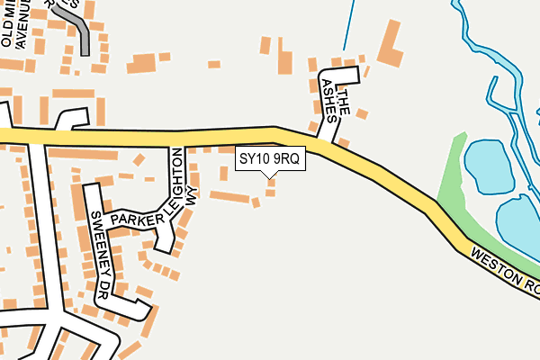
SY10 9RQ is located in the St Oswald electoral ward, within the unitary authority of Shropshire and the English Parliamentary constituency of North Shropshire. The Sub Integrated Care Board (ICB) Location is NHS Shropshire, Telford and Wrekin ICB - M2L0M and the police force is West Mercia. This postcode has been in use since June 2017.


GetTheData
Source: OS OpenMap – Local (Ordnance Survey)
Source: OS VectorMap District (Ordnance Survey)
Licence: Open Government Licence (requires attribution)
| Easting | 329115 |
| Northing | 327715 |
| Latitude | 52.842274 |
| Longitude | -3.053840 |
GetTheData
Source: Open Postcode Geo
Licence: Open Government Licence
| Country | England |
| Postcode District | SY10 |
➜ See where SY10 is on a map | |
GetTheData
Source: Land Registry Price Paid Data
Licence: Open Government Licence
| Ward | St Oswald |
| Constituency | North Shropshire |
GetTheData
Source: ONS Postcode Database
Licence: Open Government Licence
| The Jays (Sunnyside) | Morda | 301m |
| Trefonen Road Jct (Sunnyside) | Morda | 308m |
| The Miners Arms Ph (Trefonen Road) | Morda | 340m |
| The Miners Arms Ph (Trefonen Road) | Morda | 342m |
| The Terraces (B5069) | Morda | 376m |
GetTheData
Source: NaPTAN
Licence: Open Government Licence
| Percentage of properties with Next Generation Access | 100.0% |
| Percentage of properties with Superfast Broadband | 100.0% |
| Percentage of properties with Ultrafast Broadband | 0.0% |
| Percentage of properties with Full Fibre Broadband | 0.0% |
Superfast Broadband is between 30Mbps and 300Mbps
Ultrafast Broadband is > 300Mbps
| Median download speed | 40.0Mbps |
| Average download speed | 41.5Mbps |
| Maximum download speed | 79.96Mbps |
| Median upload speed | 10.0Mbps |
| Average upload speed | 9.8Mbps |
| Maximum upload speed | 19.78Mbps |
| Percentage of properties unable to receive 2Mbps | 0.0% |
| Percentage of properties unable to receive 5Mbps | 0.0% |
| Percentage of properties unable to receive 10Mbps | 0.0% |
| Percentage of properties unable to receive 30Mbps | 0.0% |
GetTheData
Source: Ofcom
Licence: Ofcom Terms of Use (requires attribution)
GetTheData
Source: ONS Postcode Database
Licence: Open Government Licence


➜ Get more ratings from the Food Standards Agency
GetTheData
Source: Food Standards Agency
Licence: FSA terms & conditions
| Last Collection | |||
|---|---|---|---|
| Location | Mon-Fri | Sat | Distance |
| Morda Post Office | 17:15 | 09:30 | 309m |
| Salop Road | 17:45 | 11:30 | 1,734m |
| Middleton Road | 17:45 | 11:30 | 1,882m |
GetTheData
Source: Dracos
Licence: Creative Commons Attribution-ShareAlike
The below table lists the International Territorial Level (ITL) codes (formerly Nomenclature of Territorial Units for Statistics (NUTS) codes) and Local Administrative Units (LAU) codes for SY10 9RQ:
| ITL 1 Code | Name |
|---|---|
| TLG | West Midlands (England) |
| ITL 2 Code | Name |
| TLG2 | Shropshire and Staffordshire |
| ITL 3 Code | Name |
| TLG22 | Shropshire |
| LAU 1 Code | Name |
| E06000051 | Shropshire |
GetTheData
Source: ONS Postcode Directory
Licence: Open Government Licence
The below table lists the Census Output Area (OA), Lower Layer Super Output Area (LSOA), and Middle Layer Super Output Area (MSOA) for SY10 9RQ:
| Code | Name | |
|---|---|---|
| OA | E00147274 | |
| LSOA | E01028924 | Shropshire 007F |
| MSOA | E02006025 | Shropshire 007 |
GetTheData
Source: ONS Postcode Directory
Licence: Open Government Licence
| SY10 9RF | Parker Leighton Way | 68m |
| SY10 9RG | Cae Gwynn Close | 93m |
| SY10 9NS | Weston Road | 146m |
| SY10 9RH | Sweeney Drive | 154m |
| SY10 9ET | 178m | |
| SY10 9NL | Belle Vue | 203m |
| SY10 9LZ | Weston Close | 212m |
| SY10 9NJ | Belle Vue | 230m |
| SY10 9NH | Erw Wen | 247m |
| SY10 9LU | St Annes Drive | 262m |
GetTheData
Source: Open Postcode Geo; Land Registry Price Paid Data
Licence: Open Government Licence