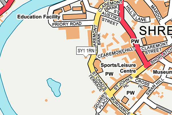
SY1 1RN is located in the Quarry and Coton Hill electoral ward, within the unitary authority of Shropshire and the English Parliamentary constituency of Shrewsbury and Atcham. The Sub Integrated Care Board (ICB) Location is NHS Shropshire, Telford and Wrekin ICB - M2L0M and the police force is West Mercia. This postcode has been in use since January 1980.


GetTheData
Source: OS OpenMap – Local (Ordnance Survey)
Source: OS VectorMap District (Ordnance Survey)
Licence: Open Government Licence (requires attribution)
| Easting | 348779 |
| Northing | 312478 |
| Latitude | 52.707531 |
| Longitude | -2.759543 |
GetTheData
Source: Open Postcode Geo
Licence: Open Government Licence
| Country | England |
| Postcode District | SY1 |
➜ See where SY1 is on a map ➜ Where is Shrewsbury? | |
GetTheData
Source: Land Registry Price Paid Data
Licence: Open Government Licence
Elevation or altitude of SY1 1RN as distance above sea level:
| Metres | Feet | |
|---|---|---|
| Elevation | 60m | 197ft |
Elevation is measured from the approximate centre of the postcode, to the nearest point on an OS contour line from OS Terrain 50, which has contour spacing of ten vertical metres.
➜ How high above sea level am I? Find the elevation of your current position using your device's GPS.
GetTheData
Source: Open Postcode Elevation
Licence: Open Government Licence
| Ward | Quarry And Coton Hill |
| Constituency | Shrewsbury And Atcham |
GetTheData
Source: ONS Postcode Database
Licence: Open Government Licence
| Barker Street P&r (Barker Street) | Shrewsbury | 172m |
| Rowleys House (Barker Street) | Shrewsbury | 172m |
| Car Park (Bridge Street) | Shrewsbury | 191m |
| Victoria Quay (Victoria Avenue) | Shrewsbury | 245m |
| Shoplatch P&r (Shoplatch) | Shrewsbury | 261m |
| Shrewsbury Station | 0.8km |
GetTheData
Source: NaPTAN
Licence: Open Government Licence
GetTheData
Source: ONS Postcode Database
Licence: Open Government Licence


➜ Get more ratings from the Food Standards Agency
GetTheData
Source: Food Standards Agency
Licence: FSA terms & conditions
| Last Collection | |||
|---|---|---|---|
| Location | Mon-Fri | Sat | Distance |
| Quarry Gates | 19:30 | 12:30 | 14m |
| Sy1 Bellstone, Shrewsbury | 19:30 | 11:15 | 205m |
| Bellstone | 19:30 | 12:30 | 205m |
GetTheData
Source: Dracos
Licence: Creative Commons Attribution-ShareAlike
The below table lists the International Territorial Level (ITL) codes (formerly Nomenclature of Territorial Units for Statistics (NUTS) codes) and Local Administrative Units (LAU) codes for SY1 1RN:
| ITL 1 Code | Name |
|---|---|
| TLG | West Midlands (England) |
| ITL 2 Code | Name |
| TLG2 | Shropshire and Staffordshire |
| ITL 3 Code | Name |
| TLG22 | Shropshire |
| LAU 1 Code | Name |
| E06000051 | Shropshire |
GetTheData
Source: ONS Postcode Directory
Licence: Open Government Licence
The below table lists the Census Output Area (OA), Lower Layer Super Output Area (LSOA), and Middle Layer Super Output Area (MSOA) for SY1 1RN:
| Code | Name | |
|---|---|---|
| OA | E00147397 | |
| LSOA | E01028946 | Shropshire 019A |
| MSOA | E02006033 | Shropshire 019 |
GetTheData
Source: ONS Postcode Directory
Licence: Open Government Licence
| SY1 1RJ | Claremont Bank | 80m |
| SY1 1RQ | Claremont Hill | 81m |
| SY1 1RW | Claremont Bank | 110m |
| SY1 1RG | Claremont Place | 117m |
| SY1 1RD | Claremont Hill | 127m |
| SY1 1JL | St Chads Terrace | 128m |
| SY1 1JJ | St Johns Hill | 145m |
| SY1 1RU | Priory Road | 153m |
| SY1 1JP | St Johns Row | 178m |
| SY1 1JN | Quarry Place | 179m |
GetTheData
Source: Open Postcode Geo; Land Registry Price Paid Data
Licence: Open Government Licence