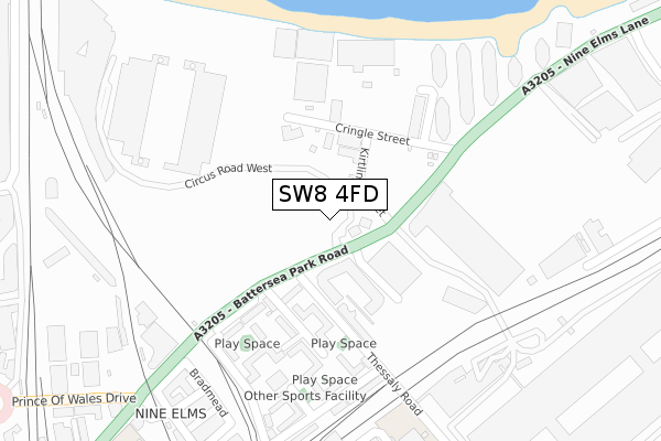
SW8 4FD is located in the Nine Elms electoral ward, within the London borough of Wandsworth and the English Parliamentary constituency of Battersea. The Sub Integrated Care Board (ICB) Location is NHS South West London ICB - 36L and the police force is Metropolitan Police. This postcode has been in use since September 2017.


GetTheData
Source: OS Open Zoomstack (Ordnance Survey)
Licence: Open Government Licence (requires attribution)
Attribution: Contains OS data © Crown copyright and database right 2025
Source: Open Postcode Geo
Licence: Open Government Licence (requires attribution)
Attribution: Contains OS data © Crown copyright and database right 2025; Contains Royal Mail data © Royal Mail copyright and database right 2025; Source: Office for National Statistics licensed under the Open Government Licence v.3.0
| Easting | 529184 |
| Northing | 177340 |
| Latitude | 51.480274 |
| Longitude | -0.141052 |
GetTheData
Source: Open Postcode Geo
Licence: Open Government Licence
| Country | England |
| Postcode District | SW8 |
➜ See where SW8 is on a map ➜ Where is London? | |
GetTheData
Source: Land Registry Price Paid Data
Licence: Open Government Licence
| Ward | Nine Elms |
| Constituency | Battersea |
GetTheData
Source: ONS Postcode Database
Licence: Open Government Licence
| Sleaford Street (Battersea Park Road) | Nine Elms | 46m |
| Sleaford Street (Battersea Park Road) | Nine Elms | 62m |
| Riverlight Quay (Battersea Park Road) | Nine Elms | 226m |
| Riverlight Quay (Battersea Park Road) | Nine Elms | 256m |
| Ascalon Street | Nine Elms | 317m |
| Pimlico Underground Station | Pimlico | 1,105m |
| Vauxhall Underground Station | Vauxhall | 1,320m |
| Stockwell Underground Station | Stockwell | 1,565m |
| Sloane Square Underground Station | Sloane Square | 1,706m |
| Battersea Park Station | 0.6km |
| Queenstown Road (Battersea) Station | 0.7km |
| Wandsworth Road Station | 1.1km |
GetTheData
Source: NaPTAN
Licence: Open Government Licence
GetTheData
Source: ONS Postcode Database
Licence: Open Government Licence


➜ Get more ratings from the Food Standards Agency
GetTheData
Source: Food Standards Agency
Licence: FSA terms & conditions
| Last Collection | |||
|---|---|---|---|
| Location | Mon-Fri | Sat | Distance |
| Havelock Terrace | 18:30 | 12:00 | 368m |
| Havelock Terrace | 18:30 | 377m | |
| Covent Garden Market | 17:30 | 12:00 | 470m |
GetTheData
Source: Dracos
Licence: Creative Commons Attribution-ShareAlike
| Risk of SW8 4FD flooding from rivers and sea | Very Low |
| ➜ SW8 4FD flood map | |
GetTheData
Source: Open Flood Risk by Postcode
Licence: Open Government Licence
The below table lists the International Territorial Level (ITL) codes (formerly Nomenclature of Territorial Units for Statistics (NUTS) codes) and Local Administrative Units (LAU) codes for SW8 4FD:
| ITL 1 Code | Name |
|---|---|
| TLI | London |
| ITL 2 Code | Name |
| TLI3 | Inner London - West |
| ITL 3 Code | Name |
| TLI34 | Wandsworth |
| LAU 1 Code | Name |
| E09000032 | Wandsworth |
GetTheData
Source: ONS Postcode Directory
Licence: Open Government Licence
The below table lists the Census Output Area (OA), Lower Layer Super Output Area (LSOA), and Middle Layer Super Output Area (MSOA) for SW8 4FD:
| Code | Name | |
|---|---|---|
| OA | E00022972 | |
| LSOA | E01033132 | Wandsworth 002H |
| MSOA | E02000924 | Wandsworth 002 |
GetTheData
Source: ONS Postcode Directory
Licence: Open Government Licence
| SW8 4DA | Battersea Park Road | 85m |
| SW8 4DB | Battersea Park Road | 85m |
| SW8 4DG | Battersea Park Road | 108m |
| SW8 4EB | Thessaly Road | 140m |
| SW8 4ED | Thessaly Road | 160m |
| SW8 4DX | Savona Street | 174m |
| SW8 4DY | Ascalon Street | 207m |
| SW8 4DZ | Ascalon Street | 207m |
| SW8 4EA | Thessaly Road | 208m |
| SW8 4DS | Battersea Park Road | 210m |
GetTheData
Source: Open Postcode Geo; Land Registry Price Paid Data
Licence: Open Government Licence