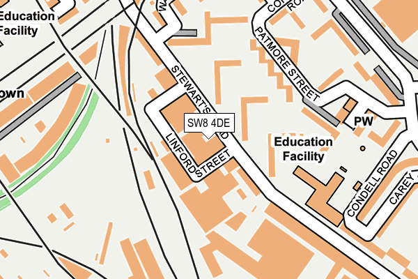
SW8 4DE lies on Stewarts Road in London. SW8 4DE is located in the Shaftesbury & Queenstown electoral ward, within the London borough of Wandsworth and the English Parliamentary constituency of Battersea. The Sub Integrated Care Board (ICB) Location is NHS South West London ICB - 36L and the police force is Metropolitan Police. This postcode has been in use since January 1980.


GetTheData
Source: OS OpenMap – Local (Ordnance Survey)
Source: OS VectorMap District (Ordnance Survey)
Licence: Open Government Licence (requires attribution)
| Easting | 529222 |
| Northing | 176748 |
| Latitude | 51.474944 |
| Longitude | -0.140746 |
GetTheData
Source: Open Postcode Geo
Licence: Open Government Licence
| Street | Stewarts Road |
| Town/City | London |
| Country | England |
| Postcode District | SW8 |
➜ See where SW8 is on a map ➜ Where is London? | |
GetTheData
Source: Land Registry Price Paid Data
Licence: Open Government Licence
Elevation or altitude of SW8 4DE as distance above sea level:
| Metres | Feet | |
|---|---|---|
| Elevation | 0m | 0ft |
Elevation is measured from the approximate centre of the postcode, to the nearest point on an OS contour line from OS Terrain 50, which has contour spacing of ten vertical metres.
➜ How high above sea level am I? Find the elevation of your current position using your device's GPS.
GetTheData
Source: Open Postcode Elevation
Licence: Open Government Licence
| Ward | Shaftesbury & Queenstown |
| Constituency | Battersea |
GetTheData
Source: ONS Postcode Database
Licence: Open Government Licence
| Linford Street (Stewarts Road) | Nine Elms | 30m |
| Patmore Estate Drury House (Stewarts Road) | Nine Elms | 143m |
| Carey Gardens (Stewarts Road) | Nine Elms | 237m |
| Corunna Road | Nine Elms | 271m |
| Ascalon Street | Nine Elms | 290m |
| Stockwell Underground Station | Stockwell | 1,295m |
| Clapham North Underground Station | Clapham | 1,322m |
| Clapham Common Underground Station | Clapham | 1,478m |
| Vauxhall Underground Station | Vauxhall | 1,662m |
| Queenstown Road (Battersea) Station | 0.4km |
| Battersea Park Station | 0.5km |
| Wandsworth Road Station | 0.5km |
GetTheData
Source: NaPTAN
Licence: Open Government Licence
GetTheData
Source: ONS Postcode Database
Licence: Open Government Licence


➜ Get more ratings from the Food Standards Agency
GetTheData
Source: Food Standards Agency
Licence: FSA terms & conditions
| Last Collection | |||
|---|---|---|---|
| Location | Mon-Fri | Sat | Distance |
| Stewarts Road | 17:30 | 12:00 | 41m |
| Ingate Place | 17:30 | 12:00 | 247m |
| Abbey Business Centre | 18:30 | 254m | |
GetTheData
Source: Dracos
Licence: Creative Commons Attribution-ShareAlike
| Risk of SW8 4DE flooding from rivers and sea | Very Low |
| ➜ SW8 4DE flood map | |
GetTheData
Source: Open Flood Risk by Postcode
Licence: Open Government Licence
The below table lists the International Territorial Level (ITL) codes (formerly Nomenclature of Territorial Units for Statistics (NUTS) codes) and Local Administrative Units (LAU) codes for SW8 4DE:
| ITL 1 Code | Name |
|---|---|
| TLI | London |
| ITL 2 Code | Name |
| TLI3 | Inner London - West |
| ITL 3 Code | Name |
| TLI34 | Wandsworth |
| LAU 1 Code | Name |
| E09000032 | Wandsworth |
GetTheData
Source: ONS Postcode Directory
Licence: Open Government Licence
The below table lists the Census Output Area (OA), Lower Layer Super Output Area (LSOA), and Middle Layer Super Output Area (MSOA) for SW8 4DE:
| Code | Name | |
|---|---|---|
| OA | E00022988 | |
| LSOA | E01004567 | Wandsworth 002E |
| MSOA | E02000924 | Wandsworth 002 |
GetTheData
Source: ONS Postcode Directory
Licence: Open Government Licence
| SW8 4UR | Patmore Estate | 61m |
| SW8 4LB | Patmore Estate | 90m |
| SW8 4UT | Patmore Estate | 91m |
| SW8 4JH | Patmore Estate | 131m |
| SW8 4DQ | Stewarts Road | 138m |
| SW8 4UG | Stewarts Road | 141m |
| SW8 4JL | Patmore Estate | 156m |
| SW8 4JQ | Patmore Estate | 164m |
| SW8 4LA | Patmore Estate | 180m |
| SW8 4JJ | Patmore Estate | 185m |
GetTheData
Source: Open Postcode Geo; Land Registry Price Paid Data
Licence: Open Government Licence