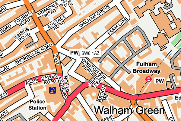
SW6 1AZ lies on Vanston Place in London. SW6 1AZ is located in the Walham Green electoral ward, within the London borough of Hammersmith and Fulham and the English Parliamentary constituency of Chelsea and Fulham. The Sub Integrated Care Board (ICB) Location is NHS North West London ICB - W2U3Z and the police force is Metropolitan Police. This postcode has been in use since January 1995.


GetTheData
Source: OS OpenMap – Local (Ordnance Survey)
Source: OS VectorMap District (Ordnance Survey)
Licence: Open Government Licence (requires attribution)
| Easting | 525257 |
| Northing | 177338 |
| Latitude | 51.481137 |
| Longitude | -0.197598 |
GetTheData
Source: Open Postcode Geo
Licence: Open Government Licence
| Street | Vanston Place |
| Town/City | London |
| Country | England |
| Postcode District | SW6 |
➜ See where SW6 is on a map ➜ Where is London? | |
GetTheData
Source: Land Registry Price Paid Data
Licence: Open Government Licence
Elevation or altitude of SW6 1AZ as distance above sea level:
| Metres | Feet | |
|---|---|---|
| Elevation | 0m | 0ft |
Elevation is measured from the approximate centre of the postcode, to the nearest point on an OS contour line from OS Terrain 50, which has contour spacing of ten vertical metres.
➜ How high above sea level am I? Find the elevation of your current position using your device's GPS.
GetTheData
Source: Open Postcode Elevation
Licence: Open Government Licence
| Ward | Walham Green |
| Constituency | Chelsea And Fulham |
GetTheData
Source: ONS Postcode Database
Licence: Open Government Licence
| Fulham Broadway (Fulham Road) | Fulham Broadway | 84m |
| Fulham Broadway (Fulham Road) | Fulham Broadway | 118m |
| Shorrolds Road (North End Road) | Walham Green | 165m |
| North End Road Dawes Road (Dawes Road) | Walham Green | 198m |
| Fulham Broadway Station (Fulham Road) | Fulham Broadway | 236m |
| Fulham Broadway Underground Station | Fulham Broadway | 192m |
| West Brompton Underground Station | West Brompton | 696m |
| Parsons Green Underground Station | Parsons Green | 698m |
| West Kensington Underground Station | West Kensington | 1,212m |
| Earl's Court Underground Station | Earls Court | 1,250m |
| West Brompton Station | 0.7km |
| Imperial Wharf Station | 1.2km |
| Kensington (Olympia) Station | 2.1km |
GetTheData
Source: NaPTAN
Licence: Open Government Licence
GetTheData
Source: ONS Postcode Database
Licence: Open Government Licence


➜ Get more ratings from the Food Standards Agency
GetTheData
Source: Food Standards Agency
Licence: FSA terms & conditions
| Last Collection | |||
|---|---|---|---|
| Location | Mon-Fri | Sat | Distance |
| 14 Farm Lane | 17:30 | 12:00 | 27m |
| Walham Grove | 17:30 | 12:00 | 120m |
| Post Office | 17:30 | 12:00 | 194m |
GetTheData
Source: Dracos
Licence: Creative Commons Attribution-ShareAlike
| Risk of SW6 1AZ flooding from rivers and sea | Very Low |
| ➜ SW6 1AZ flood map | |
GetTheData
Source: Open Flood Risk by Postcode
Licence: Open Government Licence
The below table lists the International Territorial Level (ITL) codes (formerly Nomenclature of Territorial Units for Statistics (NUTS) codes) and Local Administrative Units (LAU) codes for SW6 1AZ:
| ITL 1 Code | Name |
|---|---|
| TLI | London |
| ITL 2 Code | Name |
| TLI3 | Inner London - West |
| ITL 3 Code | Name |
| TLI33 | Kensington & Chelsea and Hammersmith & Fulham |
| LAU 1 Code | Name |
| E09000013 | Hammersmith and Fulham |
GetTheData
Source: ONS Postcode Directory
Licence: Open Government Licence
The below table lists the Census Output Area (OA), Lower Layer Super Output Area (LSOA), and Middle Layer Super Output Area (MSOA) for SW6 1AZ:
| Code | Name | |
|---|---|---|
| OA | E00009396 | |
| LSOA | E01001880 | Hammersmith and Fulham 017A |
| MSOA | E02000388 | Hammersmith and Fulham 017 |
GetTheData
Source: ONS Postcode Directory
Licence: Open Government Licence
| SW6 1BN | Farm Lane | 17m |
| SW6 1AX | Vanston Place | 24m |
| SW6 1PS | Farm Lane | 33m |
| SW6 1AB | Farm Lane | 46m |
| SW6 1DF | Farm Lane | 46m |
| SW6 1DG | Farm Lane | 46m |
| SW6 1DP | Farm Lane | 46m |
| SW6 1BE | Jerdan Place | 60m |
| SW6 1AY | Vanston Place | 68m |
| SW6 1BT | Vanston Place | 71m |
GetTheData
Source: Open Postcode Geo; Land Registry Price Paid Data
Licence: Open Government Licence