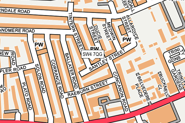
SW4 7QG is located in the Brixton Acre Lane electoral ward, within the London borough of Lambeth and the English Parliamentary constituency of Vauxhall. The Sub Integrated Care Board (ICB) Location is NHS South East London ICB - 72Q and the police force is Metropolitan Police. This postcode has been in use since January 1980.


GetTheData
Source: OS OpenMap – Local (Ordnance Survey)
Source: OS VectorMap District (Ordnance Survey)
Licence: Open Government Licence (requires attribution)
| Easting | 530504 |
| Northing | 175279 |
| Latitude | 51.461449 |
| Longitude | -0.122839 |
GetTheData
Source: Open Postcode Geo
Licence: Open Government Licence
| Country | England |
| Postcode District | SW4 |
➜ See where SW4 is on a map ➜ Where is London? | |
GetTheData
Source: Land Registry Price Paid Data
Licence: Open Government Licence
Elevation or altitude of SW4 7QG as distance above sea level:
| Metres | Feet | |
|---|---|---|
| Elevation | 20m | 66ft |
Elevation is measured from the approximate centre of the postcode, to the nearest point on an OS contour line from OS Terrain 50, which has contour spacing of ten vertical metres.
➜ How high above sea level am I? Find the elevation of your current position using your device's GPS.
GetTheData
Source: Open Postcode Elevation
Licence: Open Government Licence
| Ward | Brixton Acre Lane |
| Constituency | Vauxhall |
GetTheData
Source: ONS Postcode Database
Licence: Open Government Licence
| Solon Road | Brixton | 226m |
| Belvedere Place | Brixton | 243m |
| Solon Road | Brixton | 247m |
| Belvedere Place | Brixton | 250m |
| Lambeth Town Hall (Acre Lane) | Brixton | 381m |
| Brixton Underground Station | Brixton | 568m |
| Clapham North Underground Station | Clapham | 646m |
| Clapham Common Underground Station | Clapham | 1,076m |
| Stockwell Underground Station | Stockwell | 1,194m |
| Brixton Station | 0.6km |
| Clapham High Street Station | 0.8km |
| Wandsworth Road Station | 1.5km |
GetTheData
Source: NaPTAN
Licence: Open Government Licence
GetTheData
Source: ONS Postcode Database
Licence: Open Government Licence


➜ Get more ratings from the Food Standards Agency
GetTheData
Source: Food Standards Agency
Licence: FSA terms & conditions
| Last Collection | |||
|---|---|---|---|
| Location | Mon-Fri | Sat | Distance |
| Concannon Road | 17:30 | 12:00 | 77m |
| 120 Ferndale Road | 17:30 | 12:00 | 172m |
| Post Office | 17:30 | 12:00 | 244m |
GetTheData
Source: Dracos
Licence: Creative Commons Attribution-ShareAlike
The below table lists the International Territorial Level (ITL) codes (formerly Nomenclature of Territorial Units for Statistics (NUTS) codes) and Local Administrative Units (LAU) codes for SW4 7QG:
| ITL 1 Code | Name |
|---|---|
| TLI | London |
| ITL 2 Code | Name |
| TLI4 | Inner London - East |
| ITL 3 Code | Name |
| TLI45 | Lambeth |
| LAU 1 Code | Name |
| E09000022 | Lambeth |
GetTheData
Source: ONS Postcode Directory
Licence: Open Government Licence
The below table lists the Census Output Area (OA), Lower Layer Super Output Area (LSOA), and Middle Layer Super Output Area (MSOA) for SW4 7QG:
| Code | Name | |
|---|---|---|
| OA | E00015426 | |
| LSOA | E01003056 | Lambeth 015D |
| MSOA | E02000632 | Lambeth 015 |
GetTheData
Source: ONS Postcode Directory
Licence: Open Government Licence
| SW4 7QB | Santley Street | 35m |
| SW4 7QA | Santley Street | 39m |
| SW4 7PZ | Tintern Street | 54m |
| SW2 5QS | Ballater Road | 61m |
| SW2 5QU | Raeburn Street | 62m |
| SW4 7QF | Santley Street | 64m |
| SW2 5SZ | Concanon Road | 70m |
| SW4 7RP | Ducie Street | 77m |
| SW4 7QQ | Tintern Street | 81m |
| SW4 7RW | Ducie Street | 81m |
GetTheData
Source: Open Postcode Geo; Land Registry Price Paid Data
Licence: Open Government Licence