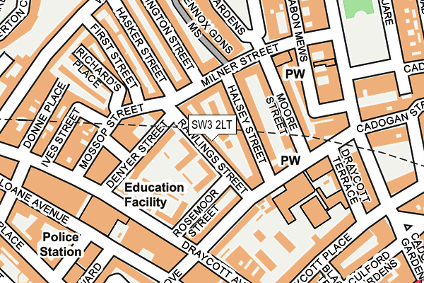
SW3 2LT lies on Rawlings Street in London. SW3 2LT is located in the Brompton & Hans Town electoral ward, within the London borough of Kensington and Chelsea and the English Parliamentary constituency of Chelsea and Fulham. The Sub Integrated Care Board (ICB) Location is NHS North West London ICB - W2U3Z and the police force is Metropolitan Police. This postcode has been in use since January 1980.


GetTheData
Source: OS OpenMap – Local (Ordnance Survey)
Source: OS VectorMap District (Ordnance Survey)
Licence: Open Government Licence (requires attribution)
| Easting | 527577 |
| Northing | 178782 |
| Latitude | 51.493596 |
| Longitude | -0.163685 |
GetTheData
Source: Open Postcode Geo
Licence: Open Government Licence
| Street | Rawlings Street |
| Town/City | London |
| Country | England |
| Postcode District | SW3 |
➜ See where SW3 is on a map ➜ Where is Chelsea? | |
GetTheData
Source: Land Registry Price Paid Data
Licence: Open Government Licence
Elevation or altitude of SW3 2LT as distance above sea level:
| Metres | Feet | |
|---|---|---|
| Elevation | 10m | 33ft |
Elevation is measured from the approximate centre of the postcode, to the nearest point on an OS contour line from OS Terrain 50, which has contour spacing of ten vertical metres.
➜ How high above sea level am I? Find the elevation of your current position using your device's GPS.
GetTheData
Source: Open Postcode Elevation
Licence: Open Government Licence
| Ward | Brompton & Hans Town |
| Constituency | Chelsea And Fulham |
GetTheData
Source: ONS Postcode Database
Licence: Open Government Licence
| Marlborough Primary School | Chelsea | 202m |
| Marlborough Primary School | Chelsea | 218m |
| Draycott Place | Brompton | 234m |
| Draycott Place | Brompton | 250m |
| Fulham Road (Sw3) | South Kensington | 330m |
| Sloane Square Underground Station | Sloane Square | 529m |
| South Kensington Underground Station | South Kensington | 728m |
| Knightsbridge Underground Station | Knightsbridge | 924m |
| Hyde Park Corner Underground Station | Hyde Park Corner | 1,308m |
| Gloucester Road Underground Station | Gloucester Road | 1,320m |
| London Victoria Station | 1.3km |
| Battersea Park Station | 2.2km |
| West Brompton Station | 2.3km |
GetTheData
Source: NaPTAN
Licence: Open Government Licence
| Percentage of properties with Next Generation Access | 100.0% |
| Percentage of properties with Superfast Broadband | 100.0% |
| Percentage of properties with Ultrafast Broadband | 100.0% |
| Percentage of properties with Full Fibre Broadband | 0.0% |
Superfast Broadband is between 30Mbps and 300Mbps
Ultrafast Broadband is > 300Mbps
| Percentage of properties unable to receive 2Mbps | 0.0% |
| Percentage of properties unable to receive 5Mbps | 0.0% |
| Percentage of properties unable to receive 10Mbps | 0.0% |
| Percentage of properties unable to receive 30Mbps | 0.0% |
GetTheData
Source: Ofcom
Licence: Ofcom Terms of Use (requires attribution)
GetTheData
Source: ONS Postcode Database
Licence: Open Government Licence


➜ Get more ratings from the Food Standards Agency
GetTheData
Source: Food Standards Agency
Licence: FSA terms & conditions
| Last Collection | |||
|---|---|---|---|
| Location | Mon-Fri | Sat | Distance |
| Rawlings Street | 17:30 | 12:00 | 66m |
| Milner Street | 18:30 | 11:30 | 133m |
| Cadogan Street | 17:30 | 12:00 | 156m |
GetTheData
Source: Dracos
Licence: Creative Commons Attribution-ShareAlike
The below table lists the International Territorial Level (ITL) codes (formerly Nomenclature of Territorial Units for Statistics (NUTS) codes) and Local Administrative Units (LAU) codes for SW3 2LT:
| ITL 1 Code | Name |
|---|---|
| TLI | London |
| ITL 2 Code | Name |
| TLI3 | Inner London - West |
| ITL 3 Code | Name |
| TLI33 | Kensington & Chelsea and Hammersmith & Fulham |
| LAU 1 Code | Name |
| E09000020 | Kensington and Chelsea |
GetTheData
Source: ONS Postcode Directory
Licence: Open Government Licence
The below table lists the Census Output Area (OA), Lower Layer Super Output Area (LSOA), and Middle Layer Super Output Area (MSOA) for SW3 2LT:
| Code | Name | |
|---|---|---|
| OA | E00014338 | |
| LSOA | E01002860 | Kensington and Chelsea 012D |
| MSOA | E02000588 | Kensington and Chelsea 012 |
GetTheData
Source: ONS Postcode Directory
Licence: Open Government Licence
| SW3 2LS | Rawlings Street | 6m |
| SW3 2NY | Wiltshire Close | 35m |
| SW3 2PT | Halsey Street | 39m |
| SW3 2PX | St Catherines Mews | 40m |
| SW3 2NZ | Wiltshire Close | 59m |
| SW3 2PU | Milner Street | 66m |
| SW3 2LR | Rawlings Street | 69m |
| SW3 2QH | Halsey Street | 69m |
| SW3 2LX | Denyer Street | 81m |
| SW3 2PR | Cadogan Street | 82m |
GetTheData
Source: Open Postcode Geo; Land Registry Price Paid Data
Licence: Open Government Licence