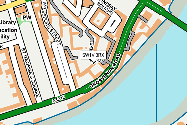
SW1V 3RX is located in the Pimlico South electoral ward, within the London borough of Westminster and the English Parliamentary constituency of Cities of London and Westminster. The Sub Integrated Care Board (ICB) Location is NHS North West London ICB - W2U3Z and the police force is Metropolitan Police. This postcode has been in use since January 1980.


GetTheData
Source: OS OpenMap – Local (Ordnance Survey)
Source: OS VectorMap District (Ordnance Survey)
Licence: Open Government Licence (requires attribution)
| Easting | 529799 |
| Northing | 178094 |
| Latitude | 51.486908 |
| Longitude | -0.131949 |
GetTheData
Source: Open Postcode Geo
Licence: Open Government Licence
| Country | England |
| Postcode District | SW1V |
➜ See where SW1V is on a map ➜ Where is City of Westminster? | |
GetTheData
Source: Land Registry Price Paid Data
Licence: Open Government Licence
Elevation or altitude of SW1V 3RX as distance above sea level:
| Metres | Feet | |
|---|---|---|
| Elevation | 10m | 33ft |
Elevation is measured from the approximate centre of the postcode, to the nearest point on an OS contour line from OS Terrain 50, which has contour spacing of ten vertical metres.
➜ How high above sea level am I? Find the elevation of your current position using your device's GPS.
GetTheData
Source: Open Postcode Elevation
Licence: Open Government Licence
| Ward | Pimlico South |
| Constituency | Cities Of London And Westminster |
GetTheData
Source: ONS Postcode Database
Licence: Open Government Licence
| Pimlico (Bessborough Street) | Pimlico | 247m |
| Pimlico (Bessborough Street) | Pimlico | 267m |
| Vauxhall Bridge Millbank (Vauxhall Bridge) | Pimlico | 272m |
| Wandsworth Rd Nine Elms Lane (Nine Elms Lane) | Nine Elms | 317m |
| St George's Square | Pimlico | 322m |
| Pimlico Underground Station | Pimlico | 274m |
| Vauxhall Underground Station | Vauxhall | 553m |
| Victoria Underground Station | Victoria | 1,306m |
| St. James's Park Underground Station | St James's Park | 1,410m |
| Oval Underground Station | Oval | 1,467m |
| Vauxhall Station | 0.6km |
| London Victoria Station | 1.3km |
| Battersea Park Station | 1.5km |
GetTheData
Source: NaPTAN
Licence: Open Government Licence
| Percentage of properties with Next Generation Access | 100.0% |
| Percentage of properties with Superfast Broadband | 100.0% |
| Percentage of properties with Ultrafast Broadband | 100.0% |
| Percentage of properties with Full Fibre Broadband | 100.0% |
Superfast Broadband is between 30Mbps and 300Mbps
Ultrafast Broadband is > 300Mbps
| Percentage of properties unable to receive 2Mbps | 0.0% |
| Percentage of properties unable to receive 5Mbps | 0.0% |
| Percentage of properties unable to receive 10Mbps | 0.0% |
| Percentage of properties unable to receive 30Mbps | 0.0% |
GetTheData
Source: Ofcom
Licence: Ofcom Terms of Use (requires attribution)
Estimated total energy consumption in SW1V 3RX by fuel type, 2015.
| Consumption (kWh) | 136,145 |
|---|---|
| Meter count | 17 |
| Mean (kWh/meter) | 8,009 |
| Median (kWh/meter) | 8,336 |
| Consumption (kWh) | 45,569 |
|---|---|
| Meter count | 17 |
| Mean (kWh/meter) | 2,681 |
| Median (kWh/meter) | 2,314 |
GetTheData
Source: Postcode level gas estimates: 2015 (experimental)
Source: Postcode level electricity estimates: 2015 (experimental)
Licence: Open Government Licence
GetTheData
Source: ONS Postcode Database
Licence: Open Government Licence


➜ Get more ratings from the Food Standards Agency
GetTheData
Source: Food Standards Agency
Licence: FSA terms & conditions
| Last Collection | |||
|---|---|---|---|
| Location | Mon-Fri | Sat | Distance |
| Grosvenor Road | 18:30 | 11:30 | 100m |
| 62 St.georges Square | 18:30 | 11:30 | 221m |
| Chichester Street | 18:45 | 11:30 | 287m |
GetTheData
Source: Dracos
Licence: Creative Commons Attribution-ShareAlike
| Risk of SW1V 3RX flooding from rivers and sea | Very Low |
| ➜ SW1V 3RX flood map | |
GetTheData
Source: Open Flood Risk by Postcode
Licence: Open Government Licence
The below table lists the International Territorial Level (ITL) codes (formerly Nomenclature of Territorial Units for Statistics (NUTS) codes) and Local Administrative Units (LAU) codes for SW1V 3RX:
| ITL 1 Code | Name |
|---|---|
| TLI | London |
| ITL 2 Code | Name |
| TLI3 | Inner London - West |
| ITL 3 Code | Name |
| TLI32 | Westminster |
| LAU 1 Code | Name |
| E09000033 | Westminster |
GetTheData
Source: ONS Postcode Directory
Licence: Open Government Licence
The below table lists the Census Output Area (OA), Lower Layer Super Output Area (LSOA), and Middle Layer Super Output Area (MSOA) for SW1V 3RX:
| Code | Name | |
|---|---|---|
| OA | E00023980 | |
| LSOA | E01004737 | Westminster 024C |
| MSOA | E02000983 | Westminster 024 |
GetTheData
Source: ONS Postcode Directory
Licence: Open Government Licence
| SW1V 3SN | Balvaird Place | 70m |
| SW1V 3JS | Grosvenor Road | 91m |
| SW1V 3RZ | St Georges Square Mews | 117m |
| SW1V 3LD | Grosvenor Road | 119m |
| SW1V 3RY | Aylesford Street | 123m |
| SW1V 3SE | Bessborough Place | 128m |
| SW1V 3QP | St Georges Square | 129m |
| SW1V 3SB | Lindsay Square | 135m |
| SW1V 3SG | Bessborough Place | 137m |
| SW1V 3SD | Balniel Gate | 148m |
GetTheData
Source: Open Postcode Geo; Land Registry Price Paid Data
Licence: Open Government Licence