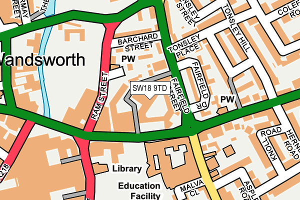
SW18 9TD is located in the Wandsworth Town electoral ward, within the London borough of Wandsworth and the English Parliamentary constituency of Battersea. The Sub Integrated Care Board (ICB) Location is NHS South West London ICB - 36L and the police force is Metropolitan Police. This postcode has been in use since March 2005.


GetTheData
Source: OS OpenMap – Local (Ordnance Survey)
Source: OS VectorMap District (Ordnance Survey)
Licence: Open Government Licence (requires attribution)
| Easting | 525790 |
| Northing | 174708 |
| Latitude | 51.457383 |
| Longitude | -0.190861 |
GetTheData
Source: Open Postcode Geo
Licence: Open Government Licence
| Country | England |
| Postcode District | SW18 |
➜ See where SW18 is on a map ➜ Where is London? | |
GetTheData
Source: Land Registry Price Paid Data
Licence: Open Government Licence
Elevation or altitude of SW18 9TD as distance above sea level:
| Metres | Feet | |
|---|---|---|
| Elevation | 10m | 33ft |
Elevation is measured from the approximate centre of the postcode, to the nearest point on an OS contour line from OS Terrain 50, which has contour spacing of ten vertical metres.
➜ How high above sea level am I? Find the elevation of your current position using your device's GPS.
GetTheData
Source: Open Postcode Elevation
Licence: Open Government Licence
| Ward | Wandsworth Town |
| Constituency | Battersea |
GetTheData
Source: ONS Postcode Database
Licence: Open Government Licence
| Wandsworth Town Hall | Wandsworth | 73m |
| Wandsworth Town Hall (Fairfield Street) | Wandsworth | 80m |
| Wandsworth Town Hall (Fairfield Street) | Wandsworth | 82m |
| Ram Street | Wandsworth | 103m |
| Ram Street | Wandsworth | 129m |
| East Putney Underground Station | East Putney | 1,414m |
| Putney Bridge Underground Station | Putney Bridge | 1,734m |
| Southfields Underground Station | Southfields | 1,753m |
| Wandsworth Town Station | 0.4km |
| Clapham Junction Station | 1.6km |
| Earlsfield Station | 1.7km |
GetTheData
Source: NaPTAN
Licence: Open Government Licence
GetTheData
Source: ONS Postcode Database
Licence: Open Government Licence


➜ Get more ratings from the Food Standards Agency
GetTheData
Source: Food Standards Agency
Licence: FSA terms & conditions
| Last Collection | |||
|---|---|---|---|
| Location | Mon-Fri | Sat | Distance |
| Arndale Centre | 17:30 | 12:00 | 210m |
| Fairfield Street | 17:30 | 12:00 | 235m |
| Armoury Way | 17:30 | 12:00 | 334m |
GetTheData
Source: Dracos
Licence: Creative Commons Attribution-ShareAlike
The below table lists the International Territorial Level (ITL) codes (formerly Nomenclature of Territorial Units for Statistics (NUTS) codes) and Local Administrative Units (LAU) codes for SW18 9TD:
| ITL 1 Code | Name |
|---|---|
| TLI | London |
| ITL 2 Code | Name |
| TLI3 | Inner London - West |
| ITL 3 Code | Name |
| TLI34 | Wandsworth |
| LAU 1 Code | Name |
| E09000032 | Wandsworth |
GetTheData
Source: ONS Postcode Directory
Licence: Open Government Licence
The below table lists the Census Output Area (OA), Lower Layer Super Output Area (LSOA), and Middle Layer Super Output Area (MSOA) for SW18 9TD:
| Code | Name | |
|---|---|---|
| OA | E00022691 | |
| LSOA | E01004514 | Wandsworth 012C |
| MSOA | E02000934 | Wandsworth 012 |
GetTheData
Source: ONS Postcode Directory
Licence: Open Government Licence
| SW18 1DL | Fairfield Drive | 87m |
| SW18 1DT | Shoreham Close | 89m |
| SW18 1DS | Fairfield Street | 105m |
| SW18 1DW | Fairfield Street | 106m |
| SW18 4LD | Wandsworth High Street | 111m |
| SW18 2PT | Wandsworth High Street | 122m |
| SW18 1DN | Fairfield Drive | 132m |
| SW18 1DP | Fairfield Street | 133m |
| SW18 1DU | Barchard Street | 137m |
| SW18 1BQ | Tonsley Place | 149m |
GetTheData
Source: Open Postcode Geo; Land Registry Price Paid Data
Licence: Open Government Licence