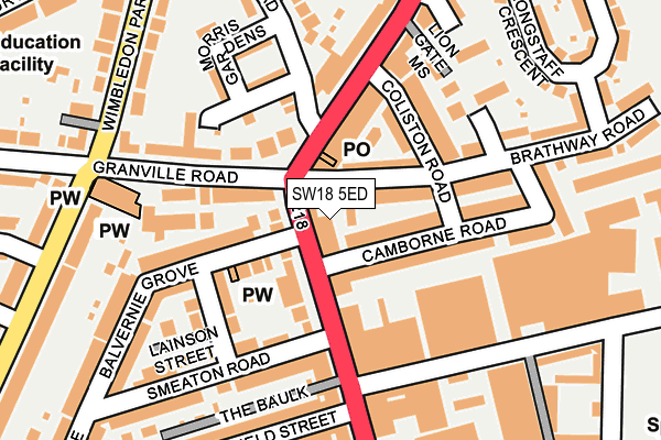
SW18 5ED lies on Camborne Mews in London. SW18 5ED is located in the Southfields electoral ward, within the London borough of Wandsworth and the English Parliamentary constituency of Putney. The Sub Integrated Care Board (ICB) Location is NHS South West London ICB - 36L and the police force is Metropolitan Police. This postcode has been in use since June 2005.


GetTheData
Source: OS OpenMap – Local (Ordnance Survey)
Source: OS VectorMap District (Ordnance Survey)
Licence: Open Government Licence (requires attribution)
| Easting | 525220 |
| Northing | 173814 |
| Latitude | 51.449475 |
| Longitude | -0.199377 |
GetTheData
Source: Open Postcode Geo
Licence: Open Government Licence
| Street | Camborne Mews |
| Town/City | London |
| Country | England |
| Postcode District | SW18 |
➜ See where SW18 is on a map ➜ Where is London? | |
GetTheData
Source: Land Registry Price Paid Data
Licence: Open Government Licence
Elevation or altitude of SW18 5ED as distance above sea level:
| Metres | Feet | |
|---|---|---|
| Elevation | 10m | 33ft |
Elevation is measured from the approximate centre of the postcode, to the nearest point on an OS contour line from OS Terrain 50, which has contour spacing of ten vertical metres.
➜ How high above sea level am I? Find the elevation of your current position using your device's GPS.
GetTheData
Source: Open Postcode Elevation
Licence: Open Government Licence
| Ward | Southfields |
| Constituency | Putney |
GetTheData
Source: ONS Postcode Database
Licence: Open Government Licence
| The Park Tavern (Merton Road) | West Hill | 79m |
| The Park Tavern (Merton Road) | West Hill | 112m |
| Granville Road (Sw18) (Granville Road) | West Hill | 124m |
| Granville Road (Sw18) (Granville Road) | West Hill | 189m |
| Standen Road (Merton Road) | West Hill | 259m |
| Southfields Underground Station | Southfields | 702m |
| East Putney Underground Station | East Putney | 1,350m |
| Earlsfield Station | 1.1km |
| Wandsworth Town Station | 1.5km |
| Putney Station | 1.8km |
GetTheData
Source: NaPTAN
Licence: Open Government Licence
| Percentage of properties with Next Generation Access | 100.0% |
| Percentage of properties with Superfast Broadband | 100.0% |
| Percentage of properties with Ultrafast Broadband | 0.0% |
| Percentage of properties with Full Fibre Broadband | 0.0% |
Superfast Broadband is between 30Mbps and 300Mbps
Ultrafast Broadband is > 300Mbps
| Median download speed | 13.3Mbps |
| Average download speed | 26.0Mbps |
| Maximum download speed | 80.00Mbps |
| Median upload speed | 1.1Mbps |
| Average upload speed | 4.9Mbps |
| Maximum upload speed | 20.00Mbps |
| Percentage of properties unable to receive 2Mbps | 0.0% |
| Percentage of properties unable to receive 5Mbps | 0.0% |
| Percentage of properties unable to receive 10Mbps | 0.0% |
| Percentage of properties unable to receive 30Mbps | 0.0% |
GetTheData
Source: Ofcom
Licence: Ofcom Terms of Use (requires attribution)
GetTheData
Source: ONS Postcode Database
Licence: Open Government Licence


➜ Get more ratings from the Food Standards Agency
GetTheData
Source: Food Standards Agency
Licence: FSA terms & conditions
| Last Collection | |||
|---|---|---|---|
| Location | Mon-Fri | Sat | Distance |
| 197 Brathway Road | 17:30 | 12:00 | 45m |
| Standen Road | 17:30 | 12:00 | 222m |
| Longstaff Crescent | 17:30 | 12:00 | 303m |
GetTheData
Source: Dracos
Licence: Creative Commons Attribution-ShareAlike
The below table lists the International Territorial Level (ITL) codes (formerly Nomenclature of Territorial Units for Statistics (NUTS) codes) and Local Administrative Units (LAU) codes for SW18 5ED:
| ITL 1 Code | Name |
|---|---|
| TLI | London |
| ITL 2 Code | Name |
| TLI3 | Inner London - West |
| ITL 3 Code | Name |
| TLI34 | Wandsworth |
| LAU 1 Code | Name |
| E09000032 | Wandsworth |
GetTheData
Source: ONS Postcode Directory
Licence: Open Government Licence
The below table lists the Census Output Area (OA), Lower Layer Super Output Area (LSOA), and Middle Layer Super Output Area (MSOA) for SW18 5ED:
| Code | Name | |
|---|---|---|
| OA | E00023160 | |
| LSOA | E01004593 | Wandsworth 025A |
| MSOA | E02000947 | Wandsworth 025 |
GetTheData
Source: ONS Postcode Directory
Licence: Open Government Licence
| SW18 5EE | Merton Road | 14m |
| SW18 5JG | Merton Road | 53m |
| SW18 5EB | Merton Road | 65m |
| SW18 5JQ | Merton Road | 68m |
| SW18 4PW | Coliston Passage | 69m |
| SW18 5RT | Balvernie Grove | 88m |
| SW18 5EF | Merton Road | 90m |
| SW18 4BE | Brathway Road | 96m |
| SW18 4BH | Camborne Road | 96m |
| SW18 5SB | Granville Road | 109m |
GetTheData
Source: Open Postcode Geo; Land Registry Price Paid Data
Licence: Open Government Licence