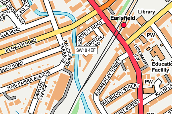
SW18 4EF is located in the Wandle electoral ward, within the London borough of Wandsworth and the English Parliamentary constituency of Tooting. The Sub Integrated Care Board (ICB) Location is NHS South West London ICB - 36L and the police force is Metropolitan Police. This postcode has been in use since June 1997.


GetTheData
Source: OS OpenMap – Local (Ordnance Survey)
Source: OS VectorMap District (Ordnance Survey)
Licence: Open Government Licence (requires attribution)
| Easting | 525925 |
| Northing | 172927 |
| Latitude | 51.441348 |
| Longitude | -0.189553 |
GetTheData
Source: Open Postcode Geo
Licence: Open Government Licence
| Country | England |
| Postcode District | SW18 |
➜ See where SW18 is on a map ➜ Where is London? | |
GetTheData
Source: Land Registry Price Paid Data
Licence: Open Government Licence
Elevation or altitude of SW18 4EF as distance above sea level:
| Metres | Feet | |
|---|---|---|
| Elevation | 10m | 33ft |
Elevation is measured from the approximate centre of the postcode, to the nearest point on an OS contour line from OS Terrain 50, which has contour spacing of ten vertical metres.
➜ How high above sea level am I? Find the elevation of your current position using your device's GPS.
GetTheData
Source: Open Postcode Elevation
Licence: Open Government Licence
| Ward | Wandle |
| Constituency | Tooting |
GetTheData
Source: ONS Postcode Database
Licence: Open Government Licence
| Earlsfield (Garratt Lane) | Earlsfield | 156m |
| Penwith Road Garratt Lane | Earlsfield | 199m |
| Earlsfield Road | Earlsfield | 205m |
| Earlsfield (Garratt Lane) | Earlsfield | 212m |
| Penwith Road Garratt Lane (Earlsfield Road) | Earlsfield | 214m |
| Wimbledon Park Underground Station | Wimbledon Park | 1,033m |
| Southfields Underground Station | Southfields | 1,255m |
| Earlsfield Station | 0.2km |
| Haydons Road Station | 1.8km |
| Wandsworth Common Station | 1.9km |
GetTheData
Source: NaPTAN
Licence: Open Government Licence
GetTheData
Source: ONS Postcode Database
Licence: Open Government Licence


➜ Get more ratings from the Food Standards Agency
GetTheData
Source: Food Standards Agency
Licence: FSA terms & conditions
| Last Collection | |||
|---|---|---|---|
| Location | Mon-Fri | Sat | Distance |
| 130 Penwith Road | 17:30 | 12:00 | 134m |
| 384 Garratt Lane | 17:30 | 12:00 | 162m |
| 591 Garratt Lane | 17:30 | 12:00 | 300m |
GetTheData
Source: Dracos
Licence: Creative Commons Attribution-ShareAlike
| Risk of SW18 4EF flooding from rivers and sea | Medium |
| ➜ SW18 4EF flood map | |
GetTheData
Source: Open Flood Risk by Postcode
Licence: Open Government Licence
The below table lists the International Territorial Level (ITL) codes (formerly Nomenclature of Territorial Units for Statistics (NUTS) codes) and Local Administrative Units (LAU) codes for SW18 4EF:
| ITL 1 Code | Name |
|---|---|
| TLI | London |
| ITL 2 Code | Name |
| TLI3 | Inner London - West |
| ITL 3 Code | Name |
| TLI34 | Wandsworth |
| LAU 1 Code | Name |
| E09000032 | Wandsworth |
GetTheData
Source: ONS Postcode Directory
Licence: Open Government Licence
The below table lists the Census Output Area (OA), Lower Layer Super Output Area (LSOA), and Middle Layer Super Output Area (MSOA) for SW18 4EF:
| Code | Name | |
|---|---|---|
| OA | E00022586 | |
| LSOA | E01004496 | Wandsworth 024B |
| MSOA | E02000946 | Wandsworth 024 |
GetTheData
Source: ONS Postcode Directory
Licence: Open Government Licence
| SW18 4EU | Summerley Street | 89m |
| SW18 4ER | Groton Road | 100m |
| SW18 4QB | Penwith Road | 106m |
| SW18 4EW | Thornsett Road | 110m |
| SW18 4EG | Highbank Place | 117m |
| SW18 4RU | Ravensbury Road | 122m |
| SW18 4EX | Summerley Street | 124m |
| SW18 4RL | Ravensbury Terrace | 126m |
| SW18 4ES | Garratt Lane | 126m |
| SW18 4PZ | Penwith Road | 136m |
GetTheData
Source: Open Postcode Geo; Land Registry Price Paid Data
Licence: Open Government Licence