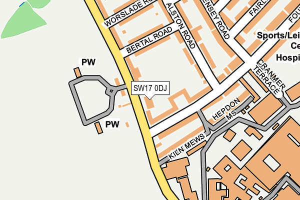
SW17 0DJ is located in the Tooting Broadway electoral ward, within the London borough of Wandsworth and the English Parliamentary constituency of Tooting. The Sub Integrated Care Board (ICB) Location is NHS South West London ICB - 36L and the police force is Metropolitan Police. This postcode has been in use since January 1980.


GetTheData
Source: OS OpenMap – Local (Ordnance Survey)
Source: OS VectorMap District (Ordnance Survey)
Licence: Open Government Licence (requires attribution)
| Easting | 526666 |
| Northing | 171428 |
| Latitude | 51.427711 |
| Longitude | -0.179432 |
GetTheData
Source: Open Postcode Geo
Licence: Open Government Licence
| Country | England |
| Postcode District | SW17 |
➜ See where SW17 is on a map ➜ Where is London? | |
GetTheData
Source: Land Registry Price Paid Data
Licence: Open Government Licence
Elevation or altitude of SW17 0DJ as distance above sea level:
| Metres | Feet | |
|---|---|---|
| Elevation | 10m | 33ft |
Elevation is measured from the approximate centre of the postcode, to the nearest point on an OS contour line from OS Terrain 50, which has contour spacing of ten vertical metres.
➜ How high above sea level am I? Find the elevation of your current position using your device's GPS.
GetTheData
Source: Open Postcode Elevation
Licence: Open Government Licence
| Ward | Tooting Broadway |
| Constituency | Tooting |
GetTheData
Source: ONS Postcode Database
Licence: Open Government Licence
| Kiln Mews | Tooting Graveney | 34m |
| Kiln Mews (Blackshaw Road) | Tooting Graveney | 118m |
| Cranmer Terrace (Fountain Road) | Tooting Graveney | 180m |
| National Blood Service | Tooting Graveney | 227m |
| St George's Univ Of London | Tooting Graveney | 294m |
| Tooting Broadway Underground Station | Tooting Broadway | 769m |
| Colliers Wood Underground Station | Collier's Wood | 1,067m |
| Wimbledon Park Underground Station | Wimbledon Park | 1,604m |
| Tooting Bec Underground Station | Tooting Bec | 1,631m |
| South Wimbledon Underground Station | South Wimbledon | 1,634m |
| Haydons Road Station | 0.7km |
| Tooting Station | 1.5km |
| Earlsfield Station | 1.7km |
GetTheData
Source: NaPTAN
Licence: Open Government Licence
GetTheData
Source: ONS Postcode Database
Licence: Open Government Licence


➜ Get more ratings from the Food Standards Agency
GetTheData
Source: Food Standards Agency
Licence: FSA terms & conditions
| Last Collection | |||
|---|---|---|---|
| Location | Mon-Fri | Sat | Distance |
| Blackshaw Road | 17:30 | 12:00 | 59m |
| Smallwood Road | 17:30 | 12:00 | 289m |
| 812 Garratt Lane | 17:30 | 12:00 | 453m |
GetTheData
Source: Dracos
Licence: Creative Commons Attribution-ShareAlike
The below table lists the International Territorial Level (ITL) codes (formerly Nomenclature of Territorial Units for Statistics (NUTS) codes) and Local Administrative Units (LAU) codes for SW17 0DJ:
| ITL 1 Code | Name |
|---|---|
| TLI | London |
| ITL 2 Code | Name |
| TLI3 | Inner London - West |
| ITL 3 Code | Name |
| TLI34 | Wandsworth |
| LAU 1 Code | Name |
| E09000032 | Wandsworth |
GetTheData
Source: ONS Postcode Directory
Licence: Open Government Licence
The below table lists the Census Output Area (OA), Lower Layer Super Output Area (LSOA), and Middle Layer Super Output Area (MSOA) for SW17 0DJ:
| Code | Name | |
|---|---|---|
| OA | E00023246 | |
| LSOA | E01004615 | Wandsworth 034B |
| MSOA | E02000956 | Wandsworth 034 |
GetTheData
Source: ONS Postcode Directory
Licence: Open Government Licence
| SW17 0HL | Fountain Road | 45m |
| SW17 0BU | Blackshaw Road | 85m |
| SW17 0HH | Fountain Road | 99m |
| SW17 0BX | Bertal Road | 108m |
| SW17 0TR | Alston Road | 113m |
| SW17 0TS | Alston Road | 114m |
| SW17 0GP | Hepdon Mews | 158m |
| SW17 0HN | Fountain Road | 160m |
| SW17 0BT | Worslade Road | 175m |
| SW17 0TP | Alston Road | 176m |
GetTheData
Source: Open Postcode Geo; Land Registry Price Paid Data
Licence: Open Government Licence