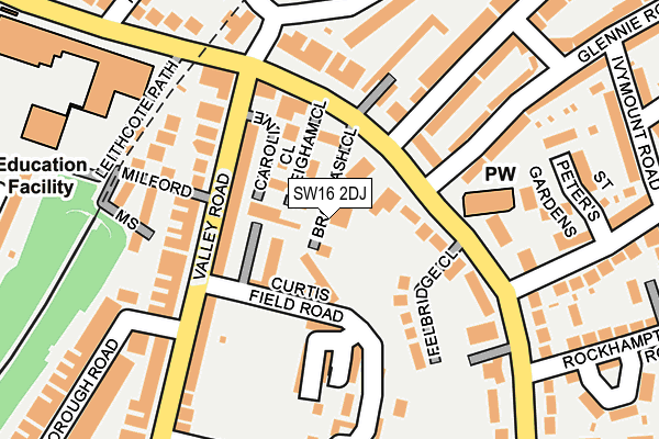
SW16 2DJ is located in the Streatham Wells electoral ward, within the London borough of Lambeth and the English Parliamentary constituency of Streatham. The Sub Integrated Care Board (ICB) Location is NHS South East London ICB - 72Q and the police force is Metropolitan Police. This postcode has been in use since February 2017.


GetTheData
Source: OS OpenMap – Local (Ordnance Survey)
Source: OS VectorMap District (Ordnance Survey)
Licence: Open Government Licence (requires attribution)
| Easting | 531008 |
| Northing | 171989 |
| Latitude | 51.431766 |
| Longitude | -0.116780 |
GetTheData
Source: Open Postcode Geo
Licence: Open Government Licence
| Country | England |
| Postcode District | SW16 |
➜ See where SW16 is on a map ➜ Where is Streatham? | |
GetTheData
Source: Land Registry Price Paid Data
Licence: Open Government Licence
| Ward | Streatham Wells |
| Constituency | Streatham |
GetTheData
Source: ONS Postcode Database
Licence: Open Government Licence
| St Peters Church (Sw16) (Leigham Court Road) | West Norwood | 63m |
| Valley Road Caroline Close | Streatham | 104m |
| Leigham Court Road Valley Road | West Norwood | 107m |
| Valley Road Caroline Close | Streatham | 129m |
| Valley Road Caroline Close | Streatham | 146m |
| West Norwood Station | 0.9km |
| Streatham Hill Station | 1km |
| Tulse Hill Station | 1.2km |
GetTheData
Source: NaPTAN
Licence: Open Government Licence
| Percentage of properties with Next Generation Access | 100.0% |
| Percentage of properties with Superfast Broadband | 100.0% |
| Percentage of properties with Ultrafast Broadband | 0.0% |
| Percentage of properties with Full Fibre Broadband | 0.0% |
Superfast Broadband is between 30Mbps and 300Mbps
Ultrafast Broadband is > 300Mbps
| Median download speed | 40.0Mbps |
| Average download speed | 43.6Mbps |
| Maximum download speed | 79.98Mbps |
| Median upload speed | 10.0Mbps |
| Average upload speed | 9.3Mbps |
| Maximum upload speed | 20.00Mbps |
| Percentage of properties unable to receive 2Mbps | 0.0% |
| Percentage of properties unable to receive 5Mbps | 0.0% |
| Percentage of properties unable to receive 10Mbps | 0.0% |
| Percentage of properties unable to receive 30Mbps | 0.0% |
GetTheData
Source: Ofcom
Licence: Ofcom Terms of Use (requires attribution)
GetTheData
Source: ONS Postcode Database
Licence: Open Government Licence


➜ Get more ratings from the Food Standards Agency
GetTheData
Source: Food Standards Agency
Licence: FSA terms & conditions
| Last Collection | |||
|---|---|---|---|
| Location | Mon-Fri | Sat | Distance |
| 86 Valley Road | 17:30 | 12:00 | 181m |
| 21 Leigham Vale | 17:30 | 12:00 | 296m |
| 60 Broxholme Road | 17:30 | 12:00 | 320m |
GetTheData
Source: Dracos
Licence: Creative Commons Attribution-ShareAlike
The below table lists the International Territorial Level (ITL) codes (formerly Nomenclature of Territorial Units for Statistics (NUTS) codes) and Local Administrative Units (LAU) codes for SW16 2DJ:
| ITL 1 Code | Name |
|---|---|
| TLI | London |
| ITL 2 Code | Name |
| TLI4 | Inner London - East |
| ITL 3 Code | Name |
| TLI45 | Lambeth |
| LAU 1 Code | Name |
| E09000022 | Lambeth |
GetTheData
Source: ONS Postcode Directory
Licence: Open Government Licence
The below table lists the Census Output Area (OA), Lower Layer Super Output Area (LSOA), and Middle Layer Super Output Area (MSOA) for SW16 2DJ:
| Code | Name | |
|---|---|---|
| OA | E00015930 | |
| LSOA | E01003154 | Lambeth 030E |
| MSOA | E02000647 | Lambeth 030 |
GetTheData
Source: ONS Postcode Directory
Licence: Open Government Licence
| SW16 2LA | Leigham Close | 34m |
| SW16 2RL | Leigham Court Road | 40m |
| SW16 2LD | Blytheswood Place | 54m |
| SW16 2RN | Leigham Court Road | 69m |
| SW16 2LF | Curtis Field Road | 75m |
| SW16 2LZ | Curtis Field Road | 83m |
| SW16 2XU | Caroline Close | 89m |
| SW16 2RJ | Leigham Court Road | 96m |
| SW16 2RH | Felbridge Close | 110m |
| SW16 2XL | Valley Road | 114m |
GetTheData
Source: Open Postcode Geo; Land Registry Price Paid Data
Licence: Open Government Licence