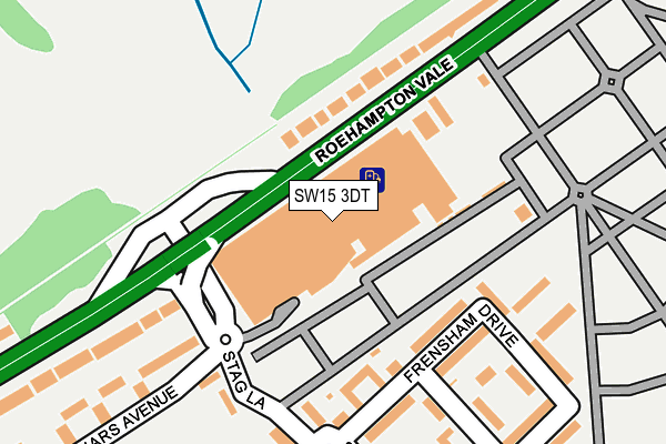
SW15 3DT is located in the Roehampton electoral ward, within the London borough of Wandsworth and the English Parliamentary constituency of Putney. The Sub Integrated Care Board (ICB) Location is NHS South West London ICB - 36L and the police force is Metropolitan Police. This postcode has been in use since February 1990.


GetTheData
Source: OS OpenMap – Local (Ordnance Survey)
Source: OS VectorMap District (Ordnance Survey)
Licence: Open Government Licence (requires attribution)
| Easting | 521986 |
| Northing | 172610 |
| Latitude | 51.439360 |
| Longitude | -0.246308 |
GetTheData
Source: Open Postcode Geo
Licence: Open Government Licence
| Country | England |
| Postcode District | SW15 |
➜ See where SW15 is on a map ➜ Where is London? | |
GetTheData
Source: Land Registry Price Paid Data
Licence: Open Government Licence
Elevation or altitude of SW15 3DT as distance above sea level:
| Metres | Feet | |
|---|---|---|
| Elevation | 20m | 66ft |
Elevation is measured from the approximate centre of the postcode, to the nearest point on an OS contour line from OS Terrain 50, which has contour spacing of ten vertical metres.
➜ How high above sea level am I? Find the elevation of your current position using your device's GPS.
GetTheData
Source: Open Postcode Elevation
Licence: Open Government Licence
| Ward | Roehampton |
| Constituency | Putney |
GetTheData
Source: ONS Postcode Database
Licence: Open Government Licence
| Roehampton Vale Asda | Putney Vale | 116m |
| Roehampton Vale Asda | Putney Vale | 130m |
| Roehampton Vale Asda | Putney Vale | 139m |
| West Lodge | Putney Vale | 225m |
| Roehampton Vale Campus | Putney Vale | 329m |
| Barnes Station | 3.1km |
| Putney Station | 3.2km |
| Wimbledon Station | 3.4km |
GetTheData
Source: NaPTAN
Licence: Open Government Licence
GetTheData
Source: ONS Postcode Database
Licence: Open Government Licence


➜ Get more ratings from the Food Standards Agency
GetTheData
Source: Food Standards Agency
Licence: FSA terms & conditions
| Last Collection | |||
|---|---|---|---|
| Location | Mon-Fri | Sat | Distance |
| 12a Frensham Drive | 17:30 | 12:00 | 209m |
| Norley Vale | 17:30 | 12:00 | 660m |
| Ibsley Gardens | 17:30 | 12:00 | 915m |
GetTheData
Source: Dracos
Licence: Creative Commons Attribution-ShareAlike
The below table lists the International Territorial Level (ITL) codes (formerly Nomenclature of Territorial Units for Statistics (NUTS) codes) and Local Administrative Units (LAU) codes for SW15 3DT:
| ITL 1 Code | Name |
|---|---|
| TLI | London |
| ITL 2 Code | Name |
| TLI3 | Inner London - West |
| ITL 3 Code | Name |
| TLI34 | Wandsworth |
| LAU 1 Code | Name |
| E09000032 | Wandsworth |
GetTheData
Source: ONS Postcode Directory
Licence: Open Government Licence
The below table lists the Census Output Area (OA), Lower Layer Super Output Area (LSOA), and Middle Layer Super Output Area (MSOA) for SW15 3DT:
| Code | Name | |
|---|---|---|
| OA | E00023029 | |
| LSOA | E01004573 | Wandsworth 023D |
| MSOA | E02000945 | Wandsworth 023 |
GetTheData
Source: ONS Postcode Directory
Licence: Open Government Licence
| SW15 3DX | Roehampton Vale | 117m |
| SW15 3EB | Frensham Drive | 139m |
| SW15 3RY | Roehampton Vale | 145m |
| SW15 3EF | Frensham Drive | 166m |
| SW15 3DZ | Stag Lane | 189m |
| SW15 3ED | Frensham Drive | 217m |
| SW15 3EA | Frensham Drive | 221m |
| SW15 3EG | Frensham Drive | 252m |
| SW15 3EL | Stroud Crescent | 253m |
| SW15 3PG | Roehampton Vale | 255m |
GetTheData
Source: Open Postcode Geo; Land Registry Price Paid Data
Licence: Open Government Licence