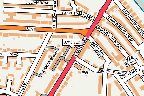
SW13 9EQ is located in the Barnes electoral ward, within the London borough of Richmond upon Thames and the English Parliamentary constituency of Richmond Park. The Sub Integrated Care Board (ICB) Location is NHS South West London ICB - 36L and the police force is Metropolitan Police. This postcode has been in use since January 2017.


GetTheData
Source: OS OpenMap – Local (Ordnance Survey)
Source: OS VectorMap District (Ordnance Survey)
Licence: Open Government Licence (requires attribution)
| Easting | 522727 |
| Northing | 177744 |
| Latitude | 51.485341 |
| Longitude | -0.233849 |
GetTheData
Source: Open Postcode Geo
Licence: Open Government Licence
| Country | England |
| Postcode District | SW13 |
➜ See where SW13 is on a map ➜ Where is Barnes? | |
GetTheData
Source: Land Registry Price Paid Data
Licence: Open Government Licence
Elevation or altitude of SW13 9EQ as distance above sea level:
| Metres | Feet | |
|---|---|---|
| Elevation | 10m | 33ft |
Elevation is measured from the approximate centre of the postcode, to the nearest point on an OS contour line from OS Terrain 50, which has contour spacing of ten vertical metres.
➜ How high above sea level am I? Find the elevation of your current position using your device's GPS.
GetTheData
Source: Open Postcode Elevation
Licence: Open Government Licence
| Ward | Barnes |
| Constituency | Richmond Park |
GetTheData
Source: ONS Postcode Database
Licence: Open Government Licence
| Lonsdale Road | Barnes | 26m |
| Lonsdale Road | Barnes | 36m |
| Lonsdale Road | Barnes | 80m |
| Lonsdale Road | Barnes | 113m |
| The Spinney (Castelnau) | Barnes | 213m |
| Ravenscourt Park Underground Station | Ravenscourt Park | 987m |
| Hammersmith (Dist&picc Line) Underground Station | Hammersmith | 1,052m |
| Hammersmith (H&c Line) Underground Station | Hammersmith | 1,100m |
| Stamford Brook Underground Station | Stamford Brook | 1,345m |
| Barons Court Underground Station | Barons Court | 1,524m |
| Barnes Bridge Station | 2km |
| Barnes Station | 2.1km |
| Kensington (Olympia) Station | 2.1km |
GetTheData
Source: NaPTAN
Licence: Open Government Licence
GetTheData
Source: ONS Postcode Database
Licence: Open Government Licence


➜ Get more ratings from the Food Standards Agency
GetTheData
Source: Food Standards Agency
Licence: FSA terms & conditions
| Last Collection | |||
|---|---|---|---|
| Location | Mon-Fri | Sat | Distance |
| Post Office | 17:30 | 12:00 | 23m |
| Castelnau | 17:30 | 12:00 | 265m |
| 125 Castelnau | 17:30 | 12:00 | 289m |
GetTheData
Source: Dracos
Licence: Creative Commons Attribution-ShareAlike
| Risk of SW13 9EQ flooding from rivers and sea | Very Low |
| ➜ SW13 9EQ flood map | |
GetTheData
Source: Open Flood Risk by Postcode
Licence: Open Government Licence
The below table lists the International Territorial Level (ITL) codes (formerly Nomenclature of Territorial Units for Statistics (NUTS) codes) and Local Administrative Units (LAU) codes for SW13 9EQ:
| ITL 1 Code | Name |
|---|---|
| TLI | London |
| ITL 2 Code | Name |
| TLI7 | Outer London - West and North West |
| ITL 3 Code | Name |
| TLI75 | Hounslow and Richmond upon Thames |
| LAU 1 Code | Name |
| E09000027 | Richmond upon Thames |
GetTheData
Source: ONS Postcode Directory
Licence: Open Government Licence
The below table lists the Census Output Area (OA), Lower Layer Super Output Area (LSOA), and Middle Layer Super Output Area (MSOA) for SW13 9EQ:
| Code | Name | |
|---|---|---|
| OA | E00019078 | |
| LSOA | E01003801 | Richmond upon Thames 001E |
| MSOA | E02000784 | Richmond upon Thames 001 |
GetTheData
Source: ONS Postcode Directory
Licence: Open Government Licence
| SW13 9ER | Castelnau | 13m |
| SW13 9EH | Blakemore Gardens | 27m |
| SW13 9EE | Castelnau Row | 35m |
| SW13 9DH | Castelnau | 51m |
| SW13 9ED | Lonsdale Road | 59m |
| SW13 8DQ | Trinity Church Passage | 59m |
| SW13 9DB | Jenner Place | 83m |
| SW13 9EY | Fielding Mews | 87m |
| SW13 8ES | Trinity Church Road | 87m |
| SW13 9DW | Castelnau | 104m |
GetTheData
Source: Open Postcode Geo; Land Registry Price Paid Data
Licence: Open Government Licence