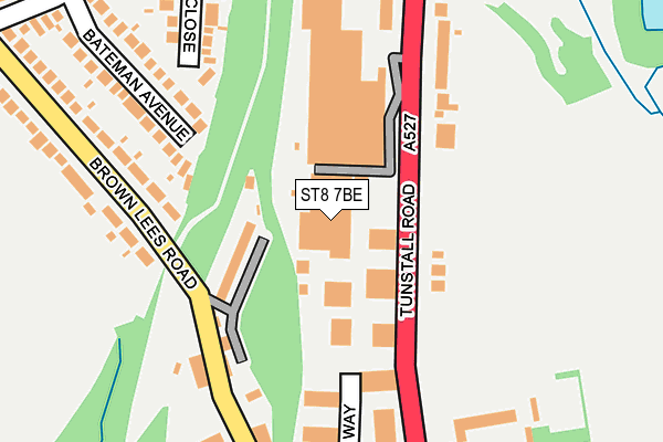
ST8 7BE is located in the Biddulph West electoral ward, within the local authority district of Staffordshire Moorlands and the English Parliamentary constituency of Staffordshire Moorlands. The Sub Integrated Care Board (ICB) Location is NHS Staffordshire and Stoke-on-Trent ICB - 05G and the police force is Staffordshire. This postcode has been in use since July 1990.


GetTheData
Source: OS OpenMap – Local (Ordnance Survey)
Source: OS VectorMap District (Ordnance Survey)
Licence: Open Government Licence (requires attribution)
| Easting | 387933 |
| Northing | 355898 |
| Latitude | 53.100143 |
| Longitude | -2.181673 |
GetTheData
Source: Open Postcode Geo
Licence: Open Government Licence
| Country | England |
| Postcode District | ST8 |
➜ See where ST8 is on a map ➜ Where is Biddulph? | |
GetTheData
Source: Land Registry Price Paid Data
Licence: Open Government Licence
Elevation or altitude of ST8 7BE as distance above sea level:
| Metres | Feet | |
|---|---|---|
| Elevation | 200m | 656ft |
Elevation is measured from the approximate centre of the postcode, to the nearest point on an OS contour line from OS Terrain 50, which has contour spacing of ten vertical metres.
➜ How high above sea level am I? Find the elevation of your current position using your device's GPS.
GetTheData
Source: Open Postcode Elevation
Licence: Open Government Licence
| Ward | Biddulph West |
| Constituency | Staffordshire Moorlands |
GetTheData
Source: ONS Postcode Database
Licence: Open Government Licence
| Industrial Estate (Tunstall Rd) | Knypersley | 67m |
| Industrial Estate (Tunstall Rd) | Knypersley | 81m |
| Victoria Court (Brown Lees Rd) | Knypersley | 188m |
| Victoria Court (Brown Lees Rd) | Knypersley | 191m |
| Brown Lees Road (Brown Lees Rd) | Brown Lees | 202m |
| Kidsgrove Station | 4.5km |
GetTheData
Source: NaPTAN
Licence: Open Government Licence
GetTheData
Source: ONS Postcode Database
Licence: Open Government Licence


➜ Get more ratings from the Food Standards Agency
GetTheData
Source: Food Standards Agency
Licence: FSA terms & conditions
| Last Collection | |||
|---|---|---|---|
| Location | Mon-Fri | Sat | Distance |
| Park Lane | 16:00 | 10:30 | 1,317m |
| John Street | 17:30 | 12:30 | 1,355m |
| Town Hall | 17:30 | 12:30 | 1,904m |
GetTheData
Source: Dracos
Licence: Creative Commons Attribution-ShareAlike
The below table lists the International Territorial Level (ITL) codes (formerly Nomenclature of Territorial Units for Statistics (NUTS) codes) and Local Administrative Units (LAU) codes for ST8 7BE:
| ITL 1 Code | Name |
|---|---|
| TLG | West Midlands (England) |
| ITL 2 Code | Name |
| TLG2 | Shropshire and Staffordshire |
| ITL 3 Code | Name |
| TLG24 | Staffordshire CC |
| LAU 1 Code | Name |
| E07000198 | Staffordshire Moorlands |
GetTheData
Source: ONS Postcode Directory
Licence: Open Government Licence
The below table lists the Census Output Area (OA), Lower Layer Super Output Area (LSOA), and Middle Layer Super Output Area (MSOA) for ST8 7BE:
| Code | Name | |
|---|---|---|
| OA | E00151712 | |
| LSOA | E01029772 | Staffordshire Moorlands 004C |
| MSOA | E02006207 | Staffordshire Moorlands 004 |
GetTheData
Source: ONS Postcode Directory
Licence: Open Government Licence
| ST8 6PL | Railway Cottages | 98m |
| ST8 6PN | Brownlees Road | 156m |
| ST8 6PW | Brownlees Road | 182m |
| ST8 6SZ | Minerva Close | 219m |
| ST8 6TD | Bateman Avenue | 221m |
| ST8 7PX | Tunstall Road | 223m |
| ST8 6SJ | Gilbern Drive | 290m |
| ST8 6PH | Brownlees Road | 294m |
| ST8 7AQ | Tunstall Road | 308m |
| ST8 6PJ | Brownlees Road | 314m |
GetTheData
Source: Open Postcode Geo; Land Registry Price Paid Data
Licence: Open Government Licence