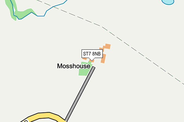
ST7 8NB lies on Eardley End Road in Bignall End, Stoke-on-trent. ST7 8NB is located in the Audley electoral ward, within the local authority district of Newcastle-under-Lyme and the English Parliamentary constituency of Newcastle-under-Lyme. The Sub Integrated Care Board (ICB) Location is NHS Staffordshire and Stoke-on-Trent ICB - 05G and the police force is Staffordshire. This postcode has been in use since January 1980.


GetTheData
Source: OS OpenMap – Local (Ordnance Survey)
Source: OS VectorMap District (Ordnance Survey)
Licence: Open Government Licence (requires attribution)
| Easting | 380600 |
| Northing | 353345 |
| Latitude | 53.076976 |
| Longitude | -2.291035 |
GetTheData
Source: Open Postcode Geo
Licence: Open Government Licence
| Street | Eardley End Road |
| Locality | Bignall End |
| Town/City | Stoke-on-trent |
| Country | England |
| Postcode District | ST7 |
➜ See where ST7 is on a map | |
GetTheData
Source: Land Registry Price Paid Data
Licence: Open Government Licence
Elevation or altitude of ST7 8NB as distance above sea level:
| Metres | Feet | |
|---|---|---|
| Elevation | 130m | 427ft |
Elevation is measured from the approximate centre of the postcode, to the nearest point on an OS contour line from OS Terrain 50, which has contour spacing of ten vertical metres.
➜ How high above sea level am I? Find the elevation of your current position using your device's GPS.
GetTheData
Source: Open Postcode Elevation
Licence: Open Government Licence
| Ward | Audley |
| Constituency | Newcastle-under-lyme |
GetTheData
Source: ONS Postcode Database
Licence: Open Government Licence
| Townhouse Day Nursery (Birch Avenue) | Alsager | 1,398m |
| Townhouse Day Nursery (Birch Avenue) | Alsager | 1,417m |
| Elsby Road | Alsager | 1,495m |
| Alsager Station | 1.9km |
| Kidsgrove Station | 3.3km |
| Longport Station | 6.3km |
GetTheData
Source: NaPTAN
Licence: Open Government Licence
GetTheData
Source: ONS Postcode Database
Licence: Open Government Licence


➜ Get more ratings from the Food Standards Agency
GetTheData
Source: Food Standards Agency
Licence: FSA terms & conditions
| Last Collection | |||
|---|---|---|---|
| Location | Mon-Fri | Sat | Distance |
| Barratt Road | 17:00 | 10:30 | 1,616m |
| Alsager Post Office | 17:30 | 11:30 | 1,760m |
| Coalpit Hill | 16:45 | 09:00 | 2,008m |
GetTheData
Source: Dracos
Licence: Creative Commons Attribution-ShareAlike
The below table lists the International Territorial Level (ITL) codes (formerly Nomenclature of Territorial Units for Statistics (NUTS) codes) and Local Administrative Units (LAU) codes for ST7 8NB:
| ITL 1 Code | Name |
|---|---|
| TLG | West Midlands (England) |
| ITL 2 Code | Name |
| TLG2 | Shropshire and Staffordshire |
| ITL 3 Code | Name |
| TLG24 | Staffordshire CC |
| LAU 1 Code | Name |
| E07000195 | Newcastle-under-Lyme |
GetTheData
Source: ONS Postcode Directory
Licence: Open Government Licence
The below table lists the Census Output Area (OA), Lower Layer Super Output Area (LSOA), and Middle Layer Super Output Area (MSOA) for ST7 8NB:
| Code | Name | |
|---|---|---|
| OA | E00150492 | |
| LSOA | E01029532 | Newcastle-under-Lyme 005A |
| MSOA | E02006162 | Newcastle-under-Lyme 005 |
GetTheData
Source: ONS Postcode Directory
Licence: Open Government Licence
| ST7 1UF | Mere Lake Road | 648m |
| ST7 8NA | Eardley End Road | 938m |
| ST7 2UQ | Audley Road | 1000m |
| ST7 8LZ | Dunkirk | 1115m |
| ST7 1UE | Mere Lake Road | 1348m |
| ST7 2YQ | Yew Tree Court | 1373m |
| ST7 8NU | Oaklea Court | 1403m |
| ST7 2RJ | Craig Walk | 1416m |
| ST7 2QX | Maple Avenue | 1419m |
| ST7 2UG | Linley Lane | 1436m |
GetTheData
Source: Open Postcode Geo; Land Registry Price Paid Data
Licence: Open Government Licence