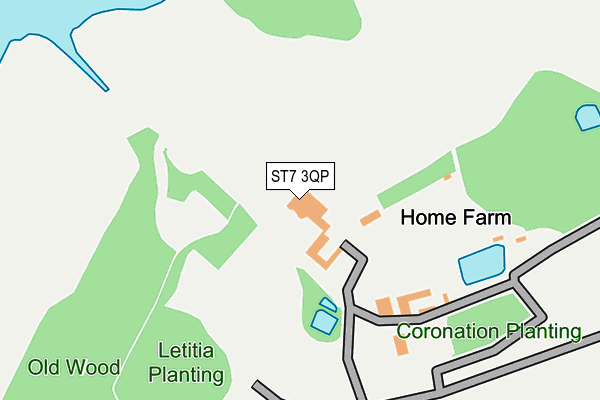
ST7 3QP is located in the Odd Rode electoral ward, within the unitary authority of Cheshire East and the English Parliamentary constituency of Congleton. The Sub Integrated Care Board (ICB) Location is NHS Cheshire and Merseyside ICB - 27D and the police force is Cheshire. This postcode has been in use since January 1980.


GetTheData
Source: OS OpenMap – Local (Ordnance Survey)
Source: OS VectorMap District (Ordnance Survey)
Licence: Open Government Licence (requires attribution)
| Easting | 381886 |
| Northing | 357343 |
| Latitude | 53.112976 |
| Longitude | -2.272066 |
GetTheData
Source: Open Postcode Geo
Licence: Open Government Licence
| Country | England |
| Postcode District | ST7 |
➜ See where ST7 is on a map | |
GetTheData
Source: Land Registry Price Paid Data
Licence: Open Government Licence
Elevation or altitude of ST7 3QP as distance above sea level:
| Metres | Feet | |
|---|---|---|
| Elevation | 100m | 328ft |
Elevation is measured from the approximate centre of the postcode, to the nearest point on an OS contour line from OS Terrain 50, which has contour spacing of ten vertical metres.
➜ How high above sea level am I? Find the elevation of your current position using your device's GPS.
GetTheData
Source: Open Postcode Elevation
Licence: Open Government Licence
| Ward | Odd Rode |
| Constituency | Congleton |
GetTheData
Source: ONS Postcode Database
Licence: Open Government Licence
| All Saints Church (Church Lane) | Scholar Green | 493m |
| All Saints Church (Church Lane) | Scholar Green | 510m |
| Lunts Moss (Church Lane) | Scholar Green | 761m |
| Lunts Moss (Church Lane) | Scholar Green | 772m |
| Pool Side | Rode Heath | 894m |
| Alsager Station | 2.9km |
| Kidsgrove Station | 3.5km |
GetTheData
Source: NaPTAN
Licence: Open Government Licence
GetTheData
Source: ONS Postcode Database
Licence: Open Government Licence


➜ Get more ratings from the Food Standards Agency
GetTheData
Source: Food Standards Agency
Licence: FSA terms & conditions
| Last Collection | |||
|---|---|---|---|
| Location | Mon-Fri | Sat | Distance |
| Odd Rode | 16:00 | 07:00 | 526m |
| Streetlane | 16:00 | 08:00 | 1,115m |
| Barratt Road | 17:00 | 10:30 | 2,589m |
GetTheData
Source: Dracos
Licence: Creative Commons Attribution-ShareAlike
The below table lists the International Territorial Level (ITL) codes (formerly Nomenclature of Territorial Units for Statistics (NUTS) codes) and Local Administrative Units (LAU) codes for ST7 3QP:
| ITL 1 Code | Name |
|---|---|
| TLD | North West (England) |
| ITL 2 Code | Name |
| TLD6 | Cheshire |
| ITL 3 Code | Name |
| TLD62 | Cheshire East |
| LAU 1 Code | Name |
| E06000049 | Cheshire East |
GetTheData
Source: ONS Postcode Directory
Licence: Open Government Licence
The below table lists the Census Output Area (OA), Lower Layer Super Output Area (LSOA), and Middle Layer Super Output Area (MSOA) for ST7 3QP:
| Code | Name | |
|---|---|---|
| OA | E00092995 | |
| LSOA | E01018431 | Cheshire East 033G |
| MSOA | E02003822 | Cheshire East 033 |
GetTheData
Source: ONS Postcode Directory
Licence: Open Government Licence
| ST7 3SL | Brereton Road | 989m |
| ST7 3QT | Knutsford Road | 994m |
| ST7 3SG | Maple Place | 1002m |
| ST7 3SE | Chapel Lane | 1007m |
| ST7 3TD | Ash Grove | 1032m |
| ST7 3SH | Beech Avenue | 1033m |
| ST7 3TR | Rode House Close | 1078m |
| ST7 3SF | Sycamore Avenue | 1085m |
| ST7 3QU | Cherry Lane | 1085m |
| ST7 3JD | Beech Avenue | 1102m |
GetTheData
Source: Open Postcode Geo; Land Registry Price Paid Data
Licence: Open Government Licence