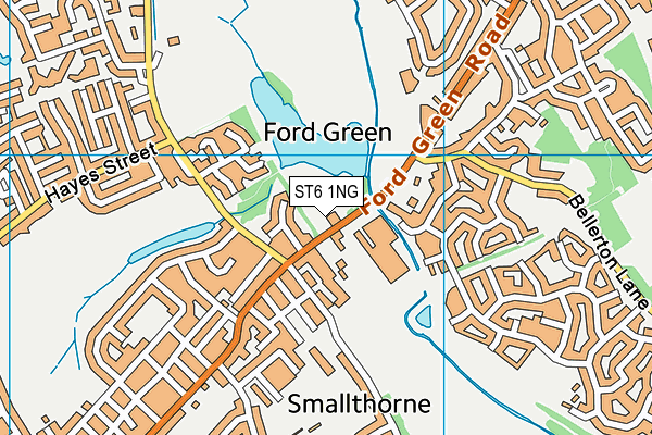
ST6 1NG is located in the Ford Green & Smallthorne electoral ward, within the unitary authority of Stoke-on-Trent and the English Parliamentary constituency of Stoke-on-Trent North. The Sub Integrated Care Board (ICB) Location is NHS Staffordshire and Stoke-on-Trent ICB - 05W and the police force is Staffordshire. This postcode has been in use since January 1980.


GetTheData
Source: OS OpenMap – Local (Ordnance Survey)
Source: OS VectorMap District (Ordnance Survey)
Licence: Open Government Licence (requires attribution)
| Easting | 388865 |
| Northing | 350841 |
| Latitude | 53.054723 |
| Longitude | -2.167577 |
GetTheData
Source: Open Postcode Geo
Licence: Open Government Licence
| Country | England |
| Postcode District | ST6 |
➜ See where ST6 is on a map ➜ Where is Stoke-on-Trent? | |
GetTheData
Source: Land Registry Price Paid Data
Licence: Open Government Licence
Elevation or altitude of ST6 1NG as distance above sea level:
| Metres | Feet | |
|---|---|---|
| Elevation | 140m | 459ft |
Elevation is measured from the approximate centre of the postcode, to the nearest point on an OS contour line from OS Terrain 50, which has contour spacing of ten vertical metres.
➜ How high above sea level am I? Find the elevation of your current position using your device's GPS.
GetTheData
Source: Open Postcode Elevation
Licence: Open Government Licence
| Ward | Ford Green & Smallthorne |
| Constituency | Stoke-on-trent North |
GetTheData
Source: ONS Postcode Database
Licence: Open Government Licence
| Ford Green House (Ford Green Road) | Ford Green | 73m |
| Ford Green House (Ford Green Road) | Ford Green | 107m |
| Ford Green Hall (Ford Green Road) | Ford Green | 177m |
| St Mary's Church (Ford Green Road) | Norton In The Moors | 229m |
| Spragg House Lane | Norton In The Moors | 260m |
| Longport Station | 3.6km |
GetTheData
Source: NaPTAN
Licence: Open Government Licence
GetTheData
Source: ONS Postcode Database
Licence: Open Government Licence


➜ Get more ratings from the Food Standards Agency
GetTheData
Source: Food Standards Agency
Licence: FSA terms & conditions
| Last Collection | |||
|---|---|---|---|
| Location | Mon-Fri | Sat | Distance |
| Crediton Avenue | 17:00 | 10:00 | 319m |
| Robin Hood Pub | 17:30 | 10:00 | 511m |
| Smallthorne Post Office | 17:15 | 11:45 | 523m |
GetTheData
Source: Dracos
Licence: Creative Commons Attribution-ShareAlike
| Risk of ST6 1NG flooding from rivers and sea | Medium |
| ➜ ST6 1NG flood map | |
GetTheData
Source: Open Flood Risk by Postcode
Licence: Open Government Licence
The below table lists the International Territorial Level (ITL) codes (formerly Nomenclature of Territorial Units for Statistics (NUTS) codes) and Local Administrative Units (LAU) codes for ST6 1NG:
| ITL 1 Code | Name |
|---|---|
| TLG | West Midlands (England) |
| ITL 2 Code | Name |
| TLG2 | Shropshire and Staffordshire |
| ITL 3 Code | Name |
| TLG23 | Stoke-on-Trent |
| LAU 1 Code | Name |
| E06000021 | Stoke-on-Trent |
GetTheData
Source: ONS Postcode Directory
Licence: Open Government Licence
The below table lists the Census Output Area (OA), Lower Layer Super Output Area (LSOA), and Middle Layer Super Output Area (MSOA) for ST6 1NG:
| Code | Name | |
|---|---|---|
| OA | E00072037 | |
| LSOA | E01014268 | Stoke-on-Trent 008C |
| MSOA | E02002958 | Stoke-on-Trent 008 |
GetTheData
Source: ONS Postcode Directory
Licence: Open Government Licence
| ST6 8EA | Ford Green Road | 101m |
| ST6 8BJ | Tudor Rose Way | 115m |
| ST6 8BW | Hyssop Place | 124m |
| ST6 8BS | Gillyflower Close | 125m |
| ST6 8BP | Row Moor Way | 186m |
| ST6 1NE | Ford Green Road | 193m |
| ST6 1NF | Ford Green Road | 202m |
| ST6 8EE | Tudor Rose Court | 220m |
| ST6 1ND | Station Crescent | 223m |
| ST6 8EF | Meadowsweet Close | 232m |
GetTheData
Source: Open Postcode Geo; Land Registry Price Paid Data
Licence: Open Government Licence