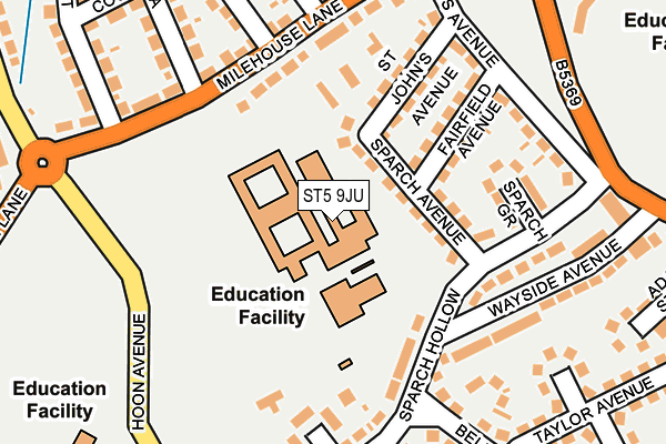
ST5 9JU is located in the May Bank electoral ward, within the local authority district of Newcastle-under-Lyme and the English Parliamentary constituency of Newcastle-under-Lyme. The Sub Integrated Care Board (ICB) Location is NHS Staffordshire and Stoke-on-Trent ICB - 05G and the police force is Staffordshire. This postcode has been in use since January 1980.


GetTheData
Source: OS OpenMap – Local (Ordnance Survey)
Source: OS VectorMap District (Ordnance Survey)
Licence: Open Government Licence (requires attribution)
| Easting | 385136 |
| Northing | 347781 |
| Latitude | 53.027108 |
| Longitude | -2.223068 |
GetTheData
Source: Open Postcode Geo
Licence: Open Government Licence
| Country | England |
| Postcode District | ST5 |
➜ See where ST5 is on a map ➜ Where is Newcastle-under-Lyme? | |
GetTheData
Source: Land Registry Price Paid Data
Licence: Open Government Licence
Elevation or altitude of ST5 9JU as distance above sea level:
| Metres | Feet | |
|---|---|---|
| Elevation | 150m | 492ft |
Elevation is measured from the approximate centre of the postcode, to the nearest point on an OS contour line from OS Terrain 50, which has contour spacing of ten vertical metres.
➜ How high above sea level am I? Find the elevation of your current position using your device's GPS.
GetTheData
Source: Open Postcode Elevation
Licence: Open Government Licence
| Ward | May Bank |
| Constituency | Newcastle-under-lyme |
GetTheData
Source: ONS Postcode Database
Licence: Open Government Licence
| High School (Hoon Avenue) | Wolstanton | 204m |
| High School (Hoon Av) | Wolstanton | 233m |
| Sparch Hollow (Hoon Avenue) | May Bank | 283m |
| Sparch Hollow (Hoon Avenue) | May Bank | 357m |
| Hollinshead Avenue (Hassam Parade) | Wolstanton | 462m |
| Longport Station | 1.7km |
| Stoke-on-Trent Station | 3.5km |
GetTheData
Source: NaPTAN
Licence: Open Government Licence
GetTheData
Source: ONS Postcode Database
Licence: Open Government Licence


➜ Get more ratings from the Food Standards Agency
GetTheData
Source: Food Standards Agency
Licence: FSA terms & conditions
| Last Collection | |||
|---|---|---|---|
| Location | Mon-Fri | Sat | Distance |
| May Avenue | 18:00 | 09:15 | 481m |
| Wolstanton Post Office | 17:00 | 12:00 | 639m |
| Basford Food & Wine Supermarke | 18:00 | 09:30 | 1,017m |
GetTheData
Source: Dracos
Licence: Creative Commons Attribution-ShareAlike
The below table lists the International Territorial Level (ITL) codes (formerly Nomenclature of Territorial Units for Statistics (NUTS) codes) and Local Administrative Units (LAU) codes for ST5 9JU:
| ITL 1 Code | Name |
|---|---|
| TLG | West Midlands (England) |
| ITL 2 Code | Name |
| TLG2 | Shropshire and Staffordshire |
| ITL 3 Code | Name |
| TLG24 | Staffordshire CC |
| LAU 1 Code | Name |
| E07000195 | Newcastle-under-Lyme |
GetTheData
Source: ONS Postcode Directory
Licence: Open Government Licence
The below table lists the Census Output Area (OA), Lower Layer Super Output Area (LSOA), and Middle Layer Super Output Area (MSOA) for ST5 9JU:
| Code | Name | |
|---|---|---|
| OA | E00150883 | |
| LSOA | E01029612 | Newcastle-under-Lyme 009E |
| MSOA | E02006166 | Newcastle-under-Lyme 009 |
GetTheData
Source: ONS Postcode Directory
Licence: Open Government Licence
| ST5 9JW | Sparch Avenue | 66m |
| ST5 9JN | Fairfield Avenue | 129m |
| ST5 9JP | St Johns Avenue | 145m |
| ST5 9PE | Sparch Hollow | 146m |
| ST5 9PG | Sparch Grove | 150m |
| ST5 9PZ | Sparch Hollow | 158m |
| ST5 9JR | Milehouse Lane | 162m |
| ST5 9PF | Sparch Hollow | 176m |
| ST5 9PB | Stuart Grove | 177m |
| ST5 9JS | Milehouse Lane | 186m |
GetTheData
Source: Open Postcode Geo; Land Registry Price Paid Data
Licence: Open Government Licence