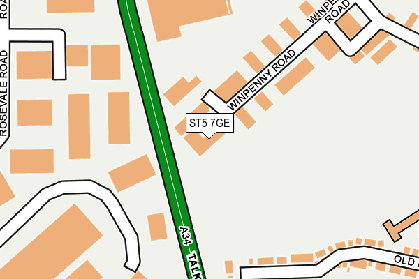
ST5 7GE is located in the Bradwell electoral ward, within the local authority district of Newcastle-under-Lyme and the English Parliamentary constituency of Newcastle-under-Lyme. The Sub Integrated Care Board (ICB) Location is NHS Staffordshire and Stoke-on-Trent ICB - 05G and the police force is Staffordshire. This postcode has been in use since September 2013.


GetTheData
Source: OS OpenMap – Local (Ordnance Survey)
Source: OS VectorMap District (Ordnance Survey)
Licence: Open Government Licence (requires attribution)
| Easting | 383867 |
| Northing | 349843 |
| Latitude | 53.045606 |
| Longitude | -2.242092 |
GetTheData
Source: Open Postcode Geo
Licence: Open Government Licence
| Country | England |
| Postcode District | ST5 |
➜ See where ST5 is on a map ➜ Where is Newcastle-under-Lyme? | |
GetTheData
Source: Land Registry Price Paid Data
Licence: Open Government Licence
Elevation or altitude of ST5 7GE as distance above sea level:
| Metres | Feet | |
|---|---|---|
| Elevation | 170m | 558ft |
Elevation is measured from the approximate centre of the postcode, to the nearest point on an OS contour line from OS Terrain 50, which has contour spacing of ten vertical metres.
➜ How high above sea level am I? Find the elevation of your current position using your device's GPS.
GetTheData
Source: Open Postcode Elevation
Licence: Open Government Licence
| Ward | Bradwell |
| Constituency | Newcastle-under-lyme |
GetTheData
Source: ONS Postcode Database
Licence: Open Government Licence
| Parkhouse Road West (Talke Road) | Parkhouse | 152m |
| Parkhouse Road West (Talke Rd) | Parkhouse | 215m |
| Bradwell Hospital (Talke Road) | Chesterton | 566m |
| Whitethorn Way (Crackley Bank) | Crackley | 588m |
| Rowley Avenue (Beasley Av) | Chesterton | 594m |
| Longport Station | 1.8km |
| Kidsgrove Station | 4.6km |
| Stoke-on-Trent Station | 5.9km |
GetTheData
Source: NaPTAN
Licence: Open Government Licence
GetTheData
Source: ONS Postcode Database
Licence: Open Government Licence


➜ Get more ratings from the Food Standards Agency
GetTheData
Source: Food Standards Agency
Licence: FSA terms & conditions
| Last Collection | |||
|---|---|---|---|
| Location | Mon-Fri | Sat | Distance |
| Bradwell Post Office | 17:30 | 11:45 | 754m |
| Pirehill Road | 18:30 | 09:00 | 1,441m |
| Station Street | 18:30 | 09:15 | 1,871m |
GetTheData
Source: Dracos
Licence: Creative Commons Attribution-ShareAlike
The below table lists the International Territorial Level (ITL) codes (formerly Nomenclature of Territorial Units for Statistics (NUTS) codes) and Local Administrative Units (LAU) codes for ST5 7GE:
| ITL 1 Code | Name |
|---|---|
| TLG | West Midlands (England) |
| ITL 2 Code | Name |
| TLG2 | Shropshire and Staffordshire |
| ITL 3 Code | Name |
| TLG24 | Staffordshire CC |
| LAU 1 Code | Name |
| E07000195 | Newcastle-under-Lyme |
GetTheData
Source: ONS Postcode Directory
Licence: Open Government Licence
The below table lists the Census Output Area (OA), Lower Layer Super Output Area (LSOA), and Middle Layer Super Output Area (MSOA) for ST5 7GE:
| Code | Name | |
|---|---|---|
| OA | E00150508 | |
| LSOA | E01029538 | Newcastle-under-Lyme 006B |
| MSOA | E02006163 | Newcastle-under-Lyme 006 |
GetTheData
Source: ONS Postcode Directory
Licence: Open Government Licence
| ST5 7RH | Winpenny Road | 151m |
| ST5 8JG | Bains Grove | 242m |
| ST5 7UB | Rosevale Business Park | 275m |
| ST5 7RB | Parkhouse Road East | 292m |
| ST5 8JF | Shawport Avenue | 345m |
| ST5 8JD | Bradwell Lane | 384m |
| ST5 8RQ | Old Hall Drive | 385m |
| ST5 7NR | Chatsworth Place | 404m |
| ST5 8JH | Talke Road | 427m |
| ST5 7RX | Hammond Road | 435m |
GetTheData
Source: Open Postcode Geo; Land Registry Price Paid Data
Licence: Open Government Licence