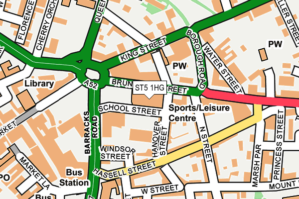
ST5 1HG is located in the Town electoral ward, within the local authority district of Newcastle-under-Lyme and the English Parliamentary constituency of Newcastle-under-Lyme. The Sub Integrated Care Board (ICB) Location is NHS Staffordshire and Stoke-on-Trent ICB - 05G and the police force is Staffordshire. This postcode has been in use since January 1980.


GetTheData
Source: OS OpenMap – Local (Ordnance Survey)
Source: OS VectorMap District (Ordnance Survey)
Licence: Open Government Licence (requires attribution)
| Easting | 385179 |
| Northing | 346143 |
| Latitude | 53.012402 |
| Longitude | -2.222351 |
GetTheData
Source: Open Postcode Geo
Licence: Open Government Licence
| Country | England |
| Postcode District | ST5 |
➜ See where ST5 is on a map ➜ Where is Newcastle-under-Lyme? | |
GetTheData
Source: Land Registry Price Paid Data
Licence: Open Government Licence
Elevation or altitude of ST5 1HG as distance above sea level:
| Metres | Feet | |
|---|---|---|
| Elevation | 130m | 427ft |
Elevation is measured from the approximate centre of the postcode, to the nearest point on an OS contour line from OS Terrain 50, which has contour spacing of ten vertical metres.
➜ How high above sea level am I? Find the elevation of your current position using your device's GPS.
GetTheData
Source: Open Postcode Elevation
Licence: Open Government Licence
| Ward | Town |
| Constituency | Newcastle-under-lyme |
GetTheData
Source: ONS Postcode Database
Licence: Open Government Licence
| Hanover Street (Brunswick Street) | Newcastle Town Centre | 19m |
| Hanover Street (King Street) | Newcastle Town Centre | 104m |
| Hanover Street (Queen St) | Newcastle Under Lyme | 179m |
| Borough Arms Hotel (King St) | Newcastle Under Lyme | 181m |
| Seagrave Street (George Street) | Newcastle Under Lyme | 188m |
| Stoke-on-Trent Station | 2.8km |
| Longport Station | 3.3km |
GetTheData
Source: NaPTAN
Licence: Open Government Licence
GetTheData
Source: ONS Postcode Database
Licence: Open Government Licence


➜ Get more ratings from the Food Standards Agency
GetTheData
Source: Food Standards Agency
Licence: FSA terms & conditions
| Last Collection | |||
|---|---|---|---|
| Location | Mon-Fri | Sat | Distance |
| Marsh Parade | 18:00 | 09:45 | 230m |
| Sidmouth Avenue | 17:30 | 11:45 | 269m |
| Newcastle Post Office | 17:30 | 12:30 | 338m |
GetTheData
Source: Dracos
Licence: Creative Commons Attribution-ShareAlike
The below table lists the International Territorial Level (ITL) codes (formerly Nomenclature of Territorial Units for Statistics (NUTS) codes) and Local Administrative Units (LAU) codes for ST5 1HG:
| ITL 1 Code | Name |
|---|---|
| TLG | West Midlands (England) |
| ITL 2 Code | Name |
| TLG2 | Shropshire and Staffordshire |
| ITL 3 Code | Name |
| TLG24 | Staffordshire CC |
| LAU 1 Code | Name |
| E07000195 | Newcastle-under-Lyme |
GetTheData
Source: ONS Postcode Directory
Licence: Open Government Licence
The below table lists the Census Output Area (OA), Lower Layer Super Output Area (LSOA), and Middle Layer Super Output Area (MSOA) for ST5 1HG:
| Code | Name | |
|---|---|---|
| OA | E00172348 | |
| LSOA | E01029602 | Newcastle-under-Lyme 011C |
| MSOA | E02006168 | Newcastle-under-Lyme 011 |
GetTheData
Source: ONS Postcode Directory
Licence: Open Government Licence
| ST5 1AU | Hanover Street | 45m |
| ST5 1HF | Brunswick Street | 55m |
| ST5 1HD | Hanover Street | 60m |
| ST5 1AZ | North Street | 115m |
| ST5 1AX | Hassell Street | 118m |
| ST5 1HH | Brunswick Street | 119m |
| ST5 1EA | Nelson Place | 126m |
| ST5 1HL | Brunswick Street | 130m |
| ST5 1AR | Hassell Street | 131m |
| ST5 1EH | King Street | 143m |
GetTheData
Source: Open Postcode Geo; Land Registry Price Paid Data
Licence: Open Government Licence