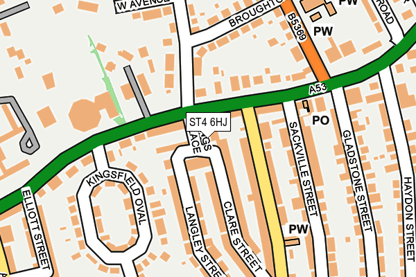
ST4 6HJ is located in the Basford & Hartshill electoral ward, within the unitary authority of Stoke-on-Trent and the English Parliamentary constituency of Stoke-on-Trent Central. The Sub Integrated Care Board (ICB) Location is NHS Staffordshire and Stoke-on-Trent ICB - 05W and the police force is Staffordshire. This postcode has been in use since January 1980.


GetTheData
Source: OS OpenMap – Local (Ordnance Survey)
Source: OS VectorMap District (Ordnance Survey)
Licence: Open Government Licence (requires attribution)
| Easting | 385870 |
| Northing | 346520 |
| Latitude | 53.015810 |
| Longitude | -2.212068 |
GetTheData
Source: Open Postcode Geo
Licence: Open Government Licence
| Country | England |
| Postcode District | ST4 |
➜ See where ST4 is on a map ➜ Where is Stoke-on-Trent? | |
GetTheData
Source: Land Registry Price Paid Data
Licence: Open Government Licence
Elevation or altitude of ST4 6HJ as distance above sea level:
| Metres | Feet | |
|---|---|---|
| Elevation | 160m | 525ft |
Elevation is measured from the approximate centre of the postcode, to the nearest point on an OS contour line from OS Terrain 50, which has contour spacing of ten vertical metres.
➜ How high above sea level am I? Find the elevation of your current position using your device's GPS.
GetTheData
Source: Open Postcode Elevation
Licence: Open Government Licence
| Ward | Basford & Hartshill |
| Constituency | Stoke-on-trent Central |
GetTheData
Source: ONS Postcode Database
Licence: Open Government Licence
| The Avenue (Etruria Road) | Etruria | 41m |
| New Victoria Theatre (Etruria Road) | Basford | 109m |
| St Mark's Church (Basford Park Road) | Basford | 219m |
| St Mark's Church (Basford Park Road) | Basford | 250m |
| Haydon Street (Etruria Road) | Basford | 277m |
| Stoke-on-Trent Station | 2.3km |
| Longport Station | 2.9km |
GetTheData
Source: NaPTAN
Licence: Open Government Licence
GetTheData
Source: ONS Postcode Database
Licence: Open Government Licence

➜ Get more ratings from the Food Standards Agency
GetTheData
Source: Food Standards Agency
Licence: FSA terms & conditions
| Last Collection | |||
|---|---|---|---|
| Location | Mon-Fri | Sat | Distance |
| Basford Post Office | 17:00 | 11:45 | 168m |
| Curzon Street | 18:00 | 09:30 | 337m |
| Basford Food & Wine Supermarke | 18:00 | 09:30 | 577m |
GetTheData
Source: Dracos
Licence: Creative Commons Attribution-ShareAlike
The below table lists the International Territorial Level (ITL) codes (formerly Nomenclature of Territorial Units for Statistics (NUTS) codes) and Local Administrative Units (LAU) codes for ST4 6HJ:
| ITL 1 Code | Name |
|---|---|
| TLG | West Midlands (England) |
| ITL 2 Code | Name |
| TLG2 | Shropshire and Staffordshire |
| ITL 3 Code | Name |
| TLG23 | Stoke-on-Trent |
| LAU 1 Code | Name |
| E06000021 | Stoke-on-Trent |
GetTheData
Source: ONS Postcode Directory
Licence: Open Government Licence
The below table lists the Census Output Area (OA), Lower Layer Super Output Area (LSOA), and Middle Layer Super Output Area (MSOA) for ST4 6HJ:
| Code | Name | |
|---|---|---|
| OA | E00072156 | |
| LSOA | E01014288 | Stoke-on-Trent 018A |
| MSOA | E02002968 | Stoke-on-Trent 018 |
GetTheData
Source: ONS Postcode Directory
Licence: Open Government Licence
| ST4 6EB | Kings Terrace | 30m |
| ST4 6HH | Etruria Road | 47m |
| ST4 6HL | Etruria Road | 66m |
| ST4 6ED | Clare Street | 92m |
| ST5 0SX | Etruria Road | 117m |
| ST4 6EA | Langley Street | 119m |
| ST4 6HT | Etruria Road | 122m |
| ST5 0SU | Etruria Road | 124m |
| ST4 6EF | Victoria Street | 131m |
| ST4 6HN | Kingsfield Oval | 136m |
GetTheData
Source: Open Postcode Geo; Land Registry Price Paid Data
Licence: Open Government Licence