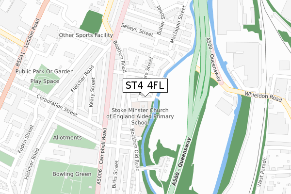
ST4 4FL is located in the Boothen electoral ward, within the unitary authority of Stoke-on-Trent and the English Parliamentary constituency of Stoke-on-Trent Central. The Sub Integrated Care Board (ICB) Location is NHS Staffordshire and Stoke-on-Trent ICB - 05W and the police force is Staffordshire. This postcode has been in use since November 2018.


GetTheData
Source: OS Open Zoomstack (Ordnance Survey)
Licence: Open Government Licence (requires attribution)
Attribution: Contains OS data © Crown copyright and database right 2024
Source: Open Postcode Geo
Licence: Open Government Licence (requires attribution)
Attribution: Contains OS data © Crown copyright and database right 2024; Contains Royal Mail data © Royal Mail copyright and database right 2024; Source: Office for National Statistics licensed under the Open Government Licence v.3.0
| Easting | 387869 |
| Northing | 344590 |
| Latitude | 52.998510 |
| Longitude | -2.182199 |
GetTheData
Source: Open Postcode Geo
Licence: Open Government Licence
| Country | England |
| Postcode District | ST4 |
➜ See where ST4 is on a map ➜ Where is Stoke-on-Trent? | |
GetTheData
Source: Land Registry Price Paid Data
Licence: Open Government Licence
| Ward | Boothen |
| Constituency | Stoke-on-trent Central |
GetTheData
Source: ONS Postcode Database
Licence: Open Government Licence
| Campbell Road | Stoke-upon-trent | 126m |
| Campbell Road | Stoke-upon-trent | 130m |
| Lonsdale Street | Stoke-upon-trent | 333m |
| Lonsdale Street | Stoke-upon-trent | 335m |
| Penkhull New Road (London Road) | Stoke-upon-trent | 445m |
| Stoke-on-Trent Station | 1.1km |
| Longton Station | 3.2km |
| Longport Station | 5.3km |
GetTheData
Source: NaPTAN
Licence: Open Government Licence
| Percentage of properties with Next Generation Access | 100.0% |
| Percentage of properties with Superfast Broadband | 100.0% |
| Percentage of properties with Ultrafast Broadband | 100.0% |
| Percentage of properties with Full Fibre Broadband | 100.0% |
Superfast Broadband is between 30Mbps and 300Mbps
Ultrafast Broadband is > 300Mbps
| Percentage of properties unable to receive 2Mbps | 0.0% |
| Percentage of properties unable to receive 5Mbps | 0.0% |
| Percentage of properties unable to receive 10Mbps | 0.0% |
| Percentage of properties unable to receive 30Mbps | 0.0% |
GetTheData
Source: Ofcom
Licence: Ofcom Terms of Use (requires attribution)
GetTheData
Source: ONS Postcode Database
Licence: Open Government Licence


➜ Get more ratings from the Food Standards Agency
GetTheData
Source: Food Standards Agency
Licence: FSA terms & conditions
| Last Collection | |||
|---|---|---|---|
| Location | Mon-Fri | Sat | Distance |
| Corporation Street | 18:00 | 10:00 | 179m |
| Sutherland Street | 16:00 | 11:15 | 435m |
| London Road Post Office | 18:00 | 10:00 | 528m |
GetTheData
Source: Dracos
Licence: Creative Commons Attribution-ShareAlike
| Risk of ST4 4FL flooding from rivers and sea | Medium |
| ➜ ST4 4FL flood map | |
GetTheData
Source: Open Flood Risk by Postcode
Licence: Open Government Licence
The below table lists the International Territorial Level (ITL) codes (formerly Nomenclature of Territorial Units for Statistics (NUTS) codes) and Local Administrative Units (LAU) codes for ST4 4FL:
| ITL 1 Code | Name |
|---|---|
| TLG | West Midlands (England) |
| ITL 2 Code | Name |
| TLG2 | Shropshire and Staffordshire |
| ITL 3 Code | Name |
| TLG23 | Stoke-on-Trent |
| LAU 1 Code | Name |
| E06000021 | Stoke-on-Trent |
GetTheData
Source: ONS Postcode Directory
Licence: Open Government Licence
The below table lists the Census Output Area (OA), Lower Layer Super Output Area (LSOA), and Middle Layer Super Output Area (MSOA) for ST4 4FL:
| Code | Name | |
|---|---|---|
| OA | E00072396 | |
| LSOA | E01014339 | Stoke-on-Trent 019C |
| MSOA | E02002969 | Stoke-on-Trent 019 |
GetTheData
Source: ONS Postcode Directory
Licence: Open Government Licence
| ST4 4EQ | Lime Street | 84m |
| ST4 4EF | Lime Street | 104m |
| ST4 4ED | Gable Street | 109m |
| ST4 4DZ | Campbell Road | 122m |
| ST4 4DU | Campbell Road | 145m |
| ST4 4EH | Windsmoor Street | 152m |
| ST4 4EA | Campbell Road | 158m |
| ST4 4AS | Keary Street | 168m |
| ST4 4EJ | Nicholls Street | 177m |
| ST4 4AT | Keary Street | 198m |
GetTheData
Source: Open Postcode Geo; Land Registry Price Paid Data
Licence: Open Government Licence