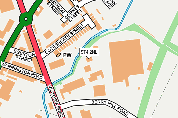
ST4 2NL is located in the Hanley Park, Joiner's Square & Shelton electoral ward, within the unitary authority of Stoke-on-Trent and the English Parliamentary constituency of Stoke-on-Trent Central. The Sub Integrated Care Board (ICB) Location is NHS Staffordshire and Stoke-on-Trent ICB - 05W and the police force is Staffordshire. This postcode has been in use since January 1980.


GetTheData
Source: OS OpenMap – Local (Ordnance Survey)
Source: OS VectorMap District (Ordnance Survey)
Licence: Open Government Licence (requires attribution)
| Easting | 388975 |
| Northing | 346305 |
| Latitude | 53.013951 |
| Longitude | -2.165778 |
GetTheData
Source: Open Postcode Geo
Licence: Open Government Licence
| Country | England |
| Postcode District | ST4 |
➜ See where ST4 is on a map ➜ Where is Stoke-on-Trent? | |
GetTheData
Source: Land Registry Price Paid Data
Licence: Open Government Licence
Elevation or altitude of ST4 2NL as distance above sea level:
| Metres | Feet | |
|---|---|---|
| Elevation | 120m | 394ft |
Elevation is measured from the approximate centre of the postcode, to the nearest point on an OS contour line from OS Terrain 50, which has contour spacing of ten vertical metres.
➜ How high above sea level am I? Find the elevation of your current position using your device's GPS.
GetTheData
Source: Open Postcode Elevation
Licence: Open Government Licence
| Ward | Hanley Park, Joiner's Square & Shelton |
| Constituency | Stoke-on-trent Central |
GetTheData
Source: ONS Postcode Database
Licence: Open Government Licence
| Berry Hill Road (Victoria Road) | Joiners Square | 173m |
| Warrington Road (Victoria Road) | Joiners Square | 184m |
| Warrington Road (Victoria Road) | Joiners Square | 248m |
| Berry Hill Road (Victoria Road) | Joiners Square | 287m |
| Leek Road (Lichfield Street) | Joiners Square | 383m |
| Stoke-on-Trent Station | 1.2km |
| Longton Station | 3.3km |
| Longport Station | 4.6km |
GetTheData
Source: NaPTAN
Licence: Open Government Licence
GetTheData
Source: ONS Postcode Database
Licence: Open Government Licence


➜ Get more ratings from the Food Standards Agency
GetTheData
Source: Food Standards Agency
Licence: FSA terms & conditions
| Last Collection | |||
|---|---|---|---|
| Location | Mon-Fri | Sat | Distance |
| James Street | 18:00 | 09:45 | 161m |
| Royal Mail | 19:00 | 13:00 | 434m |
| Leek Road | 18:15 | 09:00 | 670m |
GetTheData
Source: Dracos
Licence: Creative Commons Attribution-ShareAlike
The below table lists the International Territorial Level (ITL) codes (formerly Nomenclature of Territorial Units for Statistics (NUTS) codes) and Local Administrative Units (LAU) codes for ST4 2NL:
| ITL 1 Code | Name |
|---|---|
| TLG | West Midlands (England) |
| ITL 2 Code | Name |
| TLG2 | Shropshire and Staffordshire |
| ITL 3 Code | Name |
| TLG23 | Stoke-on-Trent |
| LAU 1 Code | Name |
| E06000021 | Stoke-on-Trent |
GetTheData
Source: ONS Postcode Directory
Licence: Open Government Licence
The below table lists the Census Output Area (OA), Lower Layer Super Output Area (LSOA), and Middle Layer Super Output Area (MSOA) for ST4 2NL:
| Code | Name | |
|---|---|---|
| OA | E00071826 | |
| LSOA | E01033216 | Stoke-on-Trent 016G |
| MSOA | E02002966 | Stoke-on-Trent 016 |
GetTheData
Source: ONS Postcode Directory
Licence: Open Government Licence
| ST1 3JD | Cotesheath Street | 148m |
| ST1 3JB | Cotesheath Street | 180m |
| ST1 3JA | Cornes Street | 208m |
| ST1 3JE | Victoria Road | 213m |
| ST1 3JF | Victoria Road | 233m |
| ST1 3JG | Warrington Road | 239m |
| ST1 3HT | Austin Street | 240m |
| ST1 3JQ | Warrington Road | 253m |
| ST1 3JH | Egerton Street | 264m |
| ST1 3HY | Austin Street | 266m |
GetTheData
Source: Open Postcode Geo; Land Registry Price Paid Data
Licence: Open Government Licence