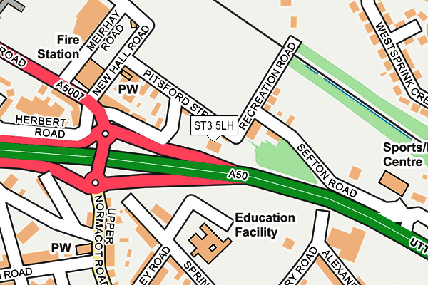
ST3 5LH is located in the Longton & Meir Hay South electoral ward, within the unitary authority of Stoke-on-Trent and the English Parliamentary constituency of Stoke-on-Trent South. The Sub Integrated Care Board (ICB) Location is NHS Staffordshire and Stoke-on-Trent ICB - 05W and the police force is Staffordshire. This postcode has been in use since June 2001.


GetTheData
Source: OS OpenMap – Local (Ordnance Survey)
Source: OS VectorMap District (Ordnance Survey)
Licence: Open Government Licence (requires attribution)
| Easting | 392130 |
| Northing | 342782 |
| Latitude | 52.982321 |
| Longitude | -2.118666 |
GetTheData
Source: Open Postcode Geo
Licence: Open Government Licence
| Country | England |
| Postcode District | ST3 |
➜ See where ST3 is on a map ➜ Where is Stoke-on-Trent? | |
GetTheData
Source: Land Registry Price Paid Data
Licence: Open Government Licence
Elevation or altitude of ST3 5LH as distance above sea level:
| Metres | Feet | |
|---|---|---|
| Elevation | 170m | 558ft |
Elevation is measured from the approximate centre of the postcode, to the nearest point on an OS contour line from OS Terrain 50, which has contour spacing of ten vertical metres.
➜ How high above sea level am I? Find the elevation of your current position using your device's GPS.
GetTheData
Source: Open Postcode Elevation
Licence: Open Government Licence
| Ward | Longton & Meir Hay South |
| Constituency | Stoke-on-trent South |
GetTheData
Source: ONS Postcode Database
Licence: Open Government Licence
| Longton Fire Station (Uttoxeter Road) | Normacot | 282m |
| Westsprink Crescent | Weston Coyney | 291m |
| Longton Fire Station (Uttoxeter Road) | Normacot | 331m |
| Upper Normacot Road (Meir Road) | Normacot | 351m |
| Tunnicliffe Close (Weston Coyney Road) | Meir Hay | 357m |
| Longton Station | 1.5km |
| Blythe Bridge Station | 3.8km |
| Wedgwood Station | 4.9km |
GetTheData
Source: NaPTAN
Licence: Open Government Licence
GetTheData
Source: ONS Postcode Database
Licence: Open Government Licence


➜ Get more ratings from the Food Standards Agency
GetTheData
Source: Food Standards Agency
Licence: FSA terms & conditions
| Last Collection | |||
|---|---|---|---|
| Location | Mon-Fri | Sat | Distance |
| Normacot Post Office | 17:00 | 12:00 | 461m |
| Lilleshall Street | 16:00 | 11:00 | 754m |
| Gladstone Pottery | 14:45 | 1,007m | |
GetTheData
Source: Dracos
Licence: Creative Commons Attribution-ShareAlike
The below table lists the International Territorial Level (ITL) codes (formerly Nomenclature of Territorial Units for Statistics (NUTS) codes) and Local Administrative Units (LAU) codes for ST3 5LH:
| ITL 1 Code | Name |
|---|---|
| TLG | West Midlands (England) |
| ITL 2 Code | Name |
| TLG2 | Shropshire and Staffordshire |
| ITL 3 Code | Name |
| TLG23 | Stoke-on-Trent |
| LAU 1 Code | Name |
| E06000021 | Stoke-on-Trent |
GetTheData
Source: ONS Postcode Directory
Licence: Open Government Licence
The below table lists the Census Output Area (OA), Lower Layer Super Output Area (LSOA), and Middle Layer Super Output Area (MSOA) for ST3 5LH:
| Code | Name | |
|---|---|---|
| OA | E00072218 | |
| LSOA | E01014302 | Stoke-on-Trent 022D |
| MSOA | E02002972 | Stoke-on-Trent 022 |
GetTheData
Source: ONS Postcode Directory
Licence: Open Government Licence
| ST3 5LN | Recreation Road | 70m |
| ST3 5LJ | Pitsford Street | 99m |
| ST3 5LW | Sefton Road | 111m |
| ST3 5LQ | Uttoxeter Road | 134m |
| ST3 4QB | Spring Road | 156m |
| ST3 4QE | Upper Normacot Road | 198m |
| ST3 4QF | Upper Normacot Road | 203m |
| ST3 4PY | Eversley Road | 219m |
| ST3 5QL | Uttoxeter Road | 225m |
| ST3 4PX | Spring Road | 236m |
GetTheData
Source: Open Postcode Geo; Land Registry Price Paid Data
Licence: Open Government Licence