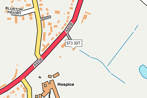
ST3 3DT lies on Meadow Drive in Stoke-on-trent. ST3 3DT is located in the Barlaston electoral ward, within the local authority district of Stafford and the English Parliamentary constituency of Stone. The Sub Integrated Care Board (ICB) Location is NHS Staffordshire and Stoke-on-Trent ICB - 05V and the police force is Staffordshire. This postcode has been in use since January 1980.


GetTheData
Source: OS OpenMap – Local (Ordnance Survey)
Source: OS VectorMap District (Ordnance Survey)
Licence: Open Government Licence (requires attribution)
| Easting | 390090 |
| Northing | 341650 |
| Latitude | 52.972128 |
| Longitude | -2.149015 |
GetTheData
Source: Open Postcode Geo
Licence: Open Government Licence
| Street | Meadow Drive |
| Town/City | Stoke-on-trent |
| Country | England |
| Postcode District | ST3 |
➜ See where ST3 is on a map ➜ Where is Stoke-on-Trent? | |
GetTheData
Source: Land Registry Price Paid Data
Licence: Open Government Licence
Elevation or altitude of ST3 3DT as distance above sea level:
| Metres | Feet | |
|---|---|---|
| Elevation | 140m | 459ft |
Elevation is measured from the approximate centre of the postcode, to the nearest point on an OS contour line from OS Terrain 50, which has contour spacing of ten vertical metres.
➜ How high above sea level am I? Find the elevation of your current position using your device's GPS.
GetTheData
Source: Open Postcode Elevation
Licence: Open Government Licence
| Ward | Barlaston |
| Constituency | Stone |
GetTheData
Source: ONS Postcode Database
Licence: Open Government Licence
MEADOWCROFT, MEADOW DRIVE, STOKE-ON-TRENT, ST3 3DT 2006 7 APR £350,000 |
GetTheData
Source: HM Land Registry Price Paid Data
Licence: Contains HM Land Registry data © Crown copyright and database right 2025. This data is licensed under the Open Government Licence v3.0.
| The Gables (Trentham Road) | Blurton | 62m |
| The Gables (Trentham Road) | Blurton | 93m |
| Douglas Macmillan Hospice (Barlaston Road) | Newstead | 266m |
| Douglas Macmillan Hospice (Barlaston Road) | Newstead | 273m |
| Maythorne Road (Trentham Road) | Blurton | 370m |
| Longton Station | 2.1km |
| Wedgwood Station | 2.8km |
| Barlaston Station | 3.5km |
GetTheData
Source: NaPTAN
Licence: Open Government Licence
GetTheData
Source: ONS Postcode Database
Licence: Open Government Licence


➜ Get more ratings from the Food Standards Agency
GetTheData
Source: Food Standards Agency
Licence: FSA terms & conditions
| Last Collection | |||
|---|---|---|---|
| Location | Mon-Fri | Sat | Distance |
| Blurton Church | 16:15 | 12:30 | 320m |
| Trentham Road | 16:30 | 12:30 | 423m |
| Maythorne Road | 16:30 | 12:00 | 509m |
GetTheData
Source: Dracos
Licence: Creative Commons Attribution-ShareAlike
The below table lists the International Territorial Level (ITL) codes (formerly Nomenclature of Territorial Units for Statistics (NUTS) codes) and Local Administrative Units (LAU) codes for ST3 3DT:
| ITL 1 Code | Name |
|---|---|
| TLG | West Midlands (England) |
| ITL 2 Code | Name |
| TLG2 | Shropshire and Staffordshire |
| ITL 3 Code | Name |
| TLG24 | Staffordshire CC |
| LAU 1 Code | Name |
| E07000197 | Stafford |
GetTheData
Source: ONS Postcode Directory
Licence: Open Government Licence
The below table lists the Census Output Area (OA), Lower Layer Super Output Area (LSOA), and Middle Layer Super Output Area (MSOA) for ST3 3DT:
| Code | Name | |
|---|---|---|
| OA | E00151238 | |
| LSOA | E01029681 | Stafford 002A |
| MSOA | E02006189 | Stafford 002 |
GetTheData
Source: ONS Postcode Directory
Licence: Open Government Licence
| ST3 3BH | Trentham Road | 112m |
| ST3 3BJ | Hinton Close | 115m |
| ST3 3DS | Trentham Road | 136m |
| ST3 3BQ | Church Road | 160m |
| ST3 3DU | School Lane | 257m |
| ST3 3PG | Blurton Priory | 275m |
| ST3 3DR | Barlaston Road | 314m |
| ST3 3LD | Barlaston Road | 340m |
| ST3 3PD | Ripon Road | 368m |
| ST3 3PB | Ripon Road | 383m |
GetTheData
Source: Open Postcode Geo; Land Registry Price Paid Data
Licence: Open Government Licence