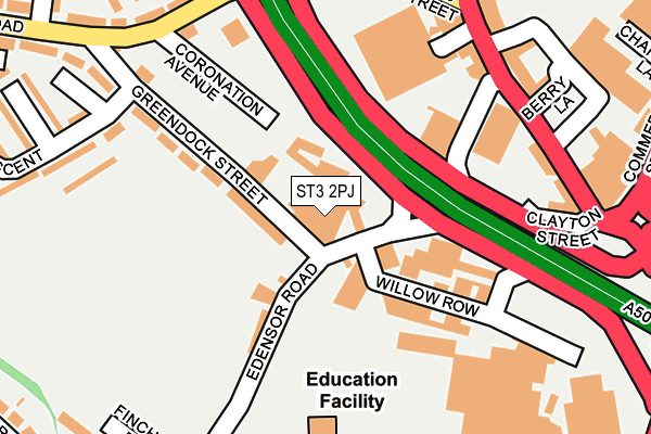
ST3 2PJ lies on Edensor Road in Stoke-on-trent. ST3 2PJ is located in the Longton & Meir Hay South electoral ward, within the unitary authority of Stoke-on-Trent and the English Parliamentary constituency of Stoke-on-Trent South. The Sub Integrated Care Board (ICB) Location is NHS Staffordshire and Stoke-on-Trent ICB - 05W and the police force is Staffordshire. This postcode has been in use since December 1994.


GetTheData
Source: OS OpenMap – Local (Ordnance Survey)
Source: OS VectorMap District (Ordnance Survey)
Licence: Open Government Licence (requires attribution)
| Easting | 390774 |
| Northing | 343177 |
| Latitude | 52.985867 |
| Longitude | -2.138874 |
GetTheData
Source: Open Postcode Geo
Licence: Open Government Licence
| Street | Edensor Road |
| Town/City | Stoke-on-trent |
| Country | England |
| Postcode District | ST3 |
➜ See where ST3 is on a map ➜ Where is Stoke-on-Trent? | |
GetTheData
Source: Land Registry Price Paid Data
Licence: Open Government Licence
Elevation or altitude of ST3 2PJ as distance above sea level:
| Metres | Feet | |
|---|---|---|
| Elevation | 140m | 459ft |
Elevation is measured from the approximate centre of the postcode, to the nearest point on an OS contour line from OS Terrain 50, which has contour spacing of ten vertical metres.
➜ How high above sea level am I? Find the elevation of your current position using your device's GPS.
GetTheData
Source: Open Postcode Elevation
Licence: Open Government Licence
| Ward | Longton & Meir Hay South |
| Constituency | Stoke-on-trent South |
GetTheData
Source: ONS Postcode Database
Licence: Open Government Licence
| Edensor Road | Goms Mill | 138m |
| Edensor Road | Goms Mill | 138m |
| Stop B (The Strand) | Longton | 206m |
| Heathcote Road | Longton | 231m |
| Stop C (The Strand) | Longton | 272m |
| Longton Station | 0.5km |
| Stoke-on-Trent Station | 3.7km |
| Wedgwood Station | 4.4km |
GetTheData
Source: NaPTAN
Licence: Open Government Licence
GetTheData
Source: ONS Postcode Database
Licence: Open Government Licence


➜ Get more ratings from the Food Standards Agency
GetTheData
Source: Food Standards Agency
Licence: FSA terms & conditions
| Last Collection | |||
|---|---|---|---|
| Location | Mon-Fri | Sat | Distance |
| The Strand | 17:30 | 11:00 | 208m |
| Gladstone Pottery | 14:45 | 497m | |
| Dresden Post Office | 16:30 | 12:00 | 772m |
GetTheData
Source: Dracos
Licence: Creative Commons Attribution-ShareAlike
The below table lists the International Territorial Level (ITL) codes (formerly Nomenclature of Territorial Units for Statistics (NUTS) codes) and Local Administrative Units (LAU) codes for ST3 2PJ:
| ITL 1 Code | Name |
|---|---|
| TLG | West Midlands (England) |
| ITL 2 Code | Name |
| TLG2 | Shropshire and Staffordshire |
| ITL 3 Code | Name |
| TLG23 | Stoke-on-Trent |
| LAU 1 Code | Name |
| E06000021 | Stoke-on-Trent |
GetTheData
Source: ONS Postcode Directory
Licence: Open Government Licence
The below table lists the Census Output Area (OA), Lower Layer Super Output Area (LSOA), and Middle Layer Super Output Area (MSOA) for ST3 2PJ:
| Code | Name | |
|---|---|---|
| OA | E00072258 | |
| LSOA | E01014313 | Stoke-on-Trent 027D |
| MSOA | E02002977 | Stoke-on-Trent 027 |
GetTheData
Source: ONS Postcode Directory
Licence: Open Government Licence
| ST3 2QE | Edensor Road | 57m |
| ST3 2NA | Greendock Street | 114m |
| ST3 2PP | Ayshford Street | 160m |
| ST3 2NU | Edensor Road | 191m |
| ST3 2NR | The Strand | 201m |
| ST3 2PD | The Strand | 210m |
| ST3 2LY | Heathcote Road | 213m |
| ST3 2JW | Gold Street | 225m |
| ST3 2LX | Heathcote Road | 247m |
| ST3 2JN | The Strand | 256m |
GetTheData
Source: Open Postcode Geo; Land Registry Price Paid Data
Licence: Open Government Licence