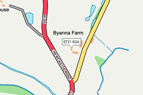
ST21 6GA lies on Newcastle Road in Eccleshall, Stafford. ST21 6GA is located in the Eccleshall electoral ward, within the local authority district of Stafford and the English Parliamentary constituency of Stone. The Sub Integrated Care Board (ICB) Location is NHS Staffordshire and Stoke-on-Trent ICB - 05V and the police force is Staffordshire. This postcode has been in use since June 2012.


GetTheData
Source: OS OpenMap – Local (Ordnance Survey)
Source: OS VectorMap District (Ordnance Survey)
Licence: Open Government Licence (requires attribution)
| Easting | 383101 |
| Northing | 329822 |
| Latitude | 52.865611 |
| Longitude | -2.252467 |
GetTheData
Source: Open Postcode Geo
Licence: Open Government Licence
| Street | Newcastle Road |
| Locality | Eccleshall |
| Town/City | Stafford |
| Country | England |
| Postcode District | ST21 |
➜ See where ST21 is on a map | |
GetTheData
Source: Land Registry Price Paid Data
Licence: Open Government Licence
Elevation or altitude of ST21 6GA as distance above sea level:
| Metres | Feet | |
|---|---|---|
| Elevation | 90m | 295ft |
Elevation is measured from the approximate centre of the postcode, to the nearest point on an OS contour line from OS Terrain 50, which has contour spacing of ten vertical metres.
➜ How high above sea level am I? Find the elevation of your current position using your device's GPS.
GetTheData
Source: Open Postcode Elevation
Licence: Open Government Licence
| Ward | Eccleshall |
| Constituency | Stone |
GetTheData
Source: ONS Postcode Database
Licence: Open Government Licence
| Newcastle Road (Castle St) | Eccleshall | 480m |
| Stone Road (Castle Street) | Eccleshall | 594m |
| Cherry Tree Close (Stone Road) | Eccleshall | 651m |
| Cherry Tree Close (Stone Rd) | Eccleshall | 661m |
| Post Office (Stafford Street) | Eccleshall | 695m |
| Norton Bridge Station | 4.2km |
GetTheData
Source: NaPTAN
Licence: Open Government Licence
GetTheData
Source: ONS Postcode Database
Licence: Open Government Licence


➜ Get more ratings from the Food Standards Agency
GetTheData
Source: Food Standards Agency
Licence: FSA terms & conditions
| Last Collection | |||
|---|---|---|---|
| Location | Mon-Fri | Sat | Distance |
| Eccleshall Post Office | 16:45 | 10:45 | 682m |
| Stone Road | 15:00 | 07:00 | 754m |
| High Street | 14:55 | 07:00 | 798m |
GetTheData
Source: Dracos
Licence: Creative Commons Attribution-ShareAlike
The below table lists the International Territorial Level (ITL) codes (formerly Nomenclature of Territorial Units for Statistics (NUTS) codes) and Local Administrative Units (LAU) codes for ST21 6GA:
| ITL 1 Code | Name |
|---|---|
| TLG | West Midlands (England) |
| ITL 2 Code | Name |
| TLG2 | Shropshire and Staffordshire |
| ITL 3 Code | Name |
| TLG24 | Staffordshire CC |
| LAU 1 Code | Name |
| E07000197 | Stafford |
GetTheData
Source: ONS Postcode Directory
Licence: Open Government Licence
The below table lists the Census Output Area (OA), Lower Layer Super Output Area (LSOA), and Middle Layer Super Output Area (MSOA) for ST21 6GA:
| Code | Name | |
|---|---|---|
| OA | E00151321 | |
| LSOA | E01029697 | Stafford 005C |
| MSOA | E02006192 | Stafford 005 |
GetTheData
Source: ONS Postcode Directory
Licence: Open Government Licence
| ST21 6LD | Swynnerton Road | 48m |
| ST21 6EZ | Castle Street | 521m |
| ST21 6DF | Castle Street | 572m |
| ST21 6DG | Castle Street | 586m |
| ST21 6DQ | Cherry Tree Close | 591m |
| ST21 6DU | Southlands Court | 612m |
| ST21 6BS | Yates Yard | 647m |
| ST21 6DJ | Stone Road | 652m |
| ST21 6DH | Meadow Close | 664m |
| ST21 6BZ | High Street | 666m |
GetTheData
Source: Open Postcode Geo; Land Registry Price Paid Data
Licence: Open Government Licence